I recently read the Wandering Canadian‘s hiking report where they came upon some drumlins in Ontario. As a huge ice sheet once covered all of Canada, it was interesting to know that these ancient remnants of glaciers are still visible.
Since then, I have found myself admiring our own local drumlins. When I showed them to a few hiking friends, I realized no one had heard of a drumlin, much less knew where to find them. I think I missed my calling as a geologist, because I find everything to do with our Rockies absolutely fascinating.
What is a Drumlin?
A drumlin is a remnant of our glaciated ice age history. It is a small, teardrop shaped hill made of glacial till. As glaciers move, grow and shrink, they churn up the rock beneath these massive sheets of ice, creating glacial till.
You might be thinking that a drumlin sounds a lot like a moraine. They are both made from the same material, but form in drastically different ways. A moraine is pushed into place by the edge of a glacier, while a drumlin is formed beneath an ice sheet.
When an ice sheet melts, it does so from above and below the ice. The below ice melting forms an under-ice river. Just like silt deposits in a regular river, the under-ice rivers would also deposit glacial till, made up of silt, sand and pulverized rock. As these deposits built up, the under-ice river would start to flow around the deposited glacial till. This is how the tear-drop shape is formed, with the blunt steep end being the start of the drumlin, and the tapered, gently sloping end being the tail end.
Where are Drumlins Found?
In Canada, drumlins were formed at two different times. The drumlins found in northern Saskatchewan heading east to Quebec were formed beneath the Laurentide Ice Sheet. The Alberta drumlins were formed during the most recent glacier period, called the Wisconsin Glaciation.
In Alberta, we see drumlins every time we drive from Calgary into the mountains. They are so close, you can reach out and touch them. Many people do touch them when they stop to make words using the stones jumbled up in the glacial till.

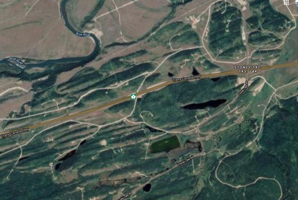
Drumlins are found in Morley flats, and around the Ghost Reservoir. They run in the same direction as the path of the glacier.
Here is an overhead view of the Morley flats drumlins.
This is a close up overhead view of one drumlin found alongside the Trans-Canada highway.

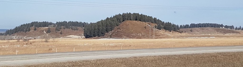
This is a sideview of a drumlin.

Here is a view of a small ‘swarm’ of drumlins.
Here is a close-up of the front of a drumlin.
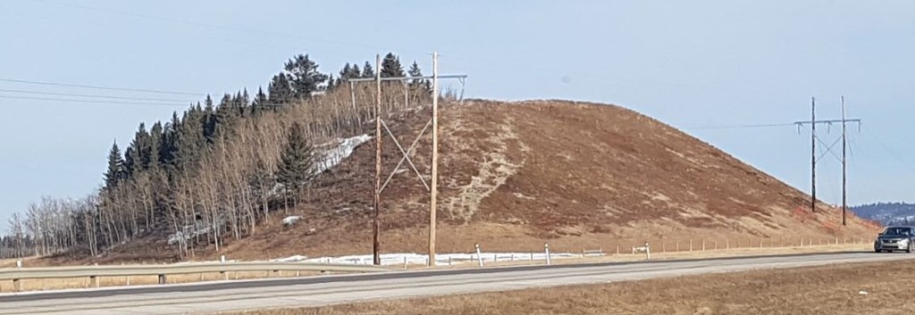
This is the tail end of the same drumlin.

Why is it called a Drumlin?
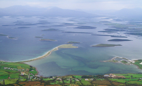
According to wikipedia, drumlin is an Irish word meaning littlest ridge. Ireland isn’t the first place I think of as covered in an ice sheet, but it must have because the drumlins of Clew Bay are somewhat famous. This is a great view of the Irish drumlins courtesy of The Geological Society.
I hope you enjoyed learning about drumlins, and discovering that they not only live among us, but that you have been driving right past them on your trek to the mountains.
If you enjoyed this information, please do me a huge favour and click the Star button to “Like” it. You can also follow my blog, follow me on Instagram, or join my FaceBook page Al’s Adventurers.
I love all things mountains! I live next door to the Canadian Rocky Mountains, however I travel the world to enjoy the many different mountain environments and cultures that I can. I hope you enjoy these trip reports, and that it inspires you to accomplish your own adventure goals.

Swarms of drumlins, who knew? How many hundreds/thousands of times that I’ve driven by those “hills” on Morley Flats without knowing that? Thanks for the geology lesson!
Drumlins, i like that word.
It’s a great word, isn’t it? Now say it with an Irish accent. Even better!
As I drove home from Lake Louise today, I pointed out the drumlins to a guy who had LANDED his King Air airplane ON TOP of a drumlin in northern Saskatchewan. Even he didn’t realize those hills were drumlins. 🙂
Fascinating! I always thought those were regular hills!
Yup! Pretty cool, eh? Now you too can point out the “swarms” of drumlins to your friends.
Haha I will!!!
I’m so glad you wrote this post that showcases some of the drumlins in Alberta. It’s fascinating how distinctly shaped they are. The drumlins we hiked along in Ontario aren’t nearly as obvious and just resemble small hills. If it weren’t for the little blurb at the trailhead at Ferris Provincial Park I wouldn’t have even known that there were drumlins in the area (or what a drumlin even is).
I’m so glad you liked it! I have been thinking about the drumlins ever since I read about YOUR hiking trip. I said I would get you some photos of ours, and I thought this would be the best way to do it. 🙂
Fascinating, indeed! Truly wow.❤️
Thank you Deborah! I’m so glad you liked it. I am fascinated by geology, and am always trying to figure out what happened in our mountains and why. It’s a never ending form of entertainment, especially when hiking for hours on end.
I love and enjoy reading posts like this. Informative and interesting. There is always something to learn. I also find it familiar since I have taught mountain formation in general science (for earth science)..but just the basics. 😊 And it is my first time to learn of drumlin. Worth sharing to my students.
Thanks.❤️
No way! I’m am so glad you learned something new. I could really pick your brain when out hiking. Whenever I get a geologist in the mountains, I think I wear them out a bit with all my questions.
I guess glaciers are part of the mountain de-construction, as opposed to the building up process.
Yes. Our subject is usually more focused on how mountains are formed since here in the Philippines we do not have glaciers. 😊 I am just so glad to learn something today. ❤️
Tell me – how are your mountains formed? Here in Alberta, it is slip fold when the neighbouring province of British Columbia unceremoniously slammed into Alberta way back when (no, I am not still holding a grudge 🙂 ).
We have limestone mountains, because this used to be ocean front property (again, no drudge held) 🙂
From what I could remember, we have many volcanic mountains. Since we lie in the pacific ring of fire. So we have, actually, many active volcanoes and inactive ones too.
Ah, I was wondering if they were volcanic. The shapes of those mountains are quite different, and made from different materials too. Very cool and interesting!
I enjoyed learning something new from your blog – drumlins!
Thank you! I appreciate the feedback. Depending on where you live, you too might have a drumlin hiding in plain sight.
I had never heard of a Drumlin, so I found this article very interesting. Thanks for posting.
Hi Geri, Thanks so much for the feedback – I do appreciate it! I didn’t realize how obscure this tidbit of geological information was. YOU might have drumlins and other glacier relics in your area too!
I remember seeing them when we traveled there, so interesting!
No way! That’s so cool. I am glad they made an impression on you. Now you have a cool tidbit for your back pocket 🙂
Yes 😂I love knowing about geography and geology but I really am a novice. 👍👍
Beautiful blog
Thank you so very much. I appreciate you coming to visit.
Like most of your other readers, I had never heard of a drumlin before. Fascinating! Now I need to find out if we have them here in northern New England.
Oooohhhh!!! I bet you do, if that area was covered in the massive ice sheet. If you do find some drumlins, please tell me.
Wow..!! A fascinating post on travel elucidating the concepts of Geology.. ☺️
I love geology and can spend hours observing the wonders of it practically. Your explanation of drumlins is extremely crisp and to the point, rightly complemented by very apt pictures of the same. I think I missed seeing drumlins in the Arctic, but again, there is so much to see everywhere in the Arctic.. ❄️❄️❄️❄️❄️❄️❄️❄️
Would love to explore Canada with you..!!
Thank you so much for your wonderful explanation.. ☺️☺️
Frankly, there are WAY more exciting things to look at in the arctic than drumlins 🙂 Glaciers, bears, salmon and the northern lights tend to steal the show 🙂
I am with you on geology. It is so fascinating. I add a little bit to my geology tool box every chance I get.
Yes – come to Canada when all this is over. You’ll LOVE it 🙂
oh yes, how can I forget the Northern Lights.. 🥰☺️ And the Fjords too..!! You are right Madam, Arctic is Amazing, and the cold and ice top the show.. 😀
I love exploring geology as well.. Seems our frequencies match on geology.. 😀 Apart from the orogeny of the Banff and the Canadian Rockies, do the Banff Parks hide any peculiar geological feature? I think they do.
Would love to explore Canada.. On priority now, thanks to you.. ☺️☺️
Hmmm… how about this: as it’s slip fold mountain creation with limestone mountains. The closser you get to the Rocky Mountain Trench, the more sea bed fossils you can find. Burgess Shale by Field in Yoho National Park is an ideal spot to find fossils. Fossils can be found just about anywhere though.
Wow.. I had only read in books that Young Fold Mountains like the Rockies or the Himalayas rose from the sea bed.
Never knew that there will actually be sea bed fossils. It will be amazing to pay a visit to the Burgess Shale Field. Amazing.. ☺️☺️
Thank you so much Madam.. You never fail to dazzle anyone with your amazing knowledge and adventures.. Simply amazing.. ☺️☺️
But Mountain Trench? Isn’t a trench supposed to be under water due to diverging plates? Rockies were created due to converging plates, right?
That is correct. Two plates did collide. The spot where they collided is called The Rocky Mountain Trench. If you google earth the Columbia River Valley (look for the town of Invermere, BC), that is the ‘trench’. On the west side are the granite mountains of British Columbia that slammed into Alberta. On the east side are the limestone slip-fold mountains that resulted from that slamming.
Years ago (like over 25 years!), I was in Greece. Mount Olympus has the giant rock slabs that make up the columns of Zeus’ temple. I remember seeing fossils in those slabs. I’d have to dig through old photos to double-check, but I’m pretty sure I saw some there.
I see. Feel great to have my theory supported by the expert herself.. ☺️
I shall look for the town of Invermere, though I am still not clear how on Earth did a trench appear atop a Fold Mountain when it should have been below the sea. Might have been an old trench which was uplifted during the orogeny of the Rockies. Not so sure about this theory.
Coming to granite mountains, that’s a peculiarity among the Rockies, especially in the US Rockies. The granite mountains rise far away from the plate boundaries, which could be explained by the presence of older and ancient granite beneath those states, which got uplifted when North American and Pacific Plates collided. Perhaps that can explain the presence of marine fossils on limestone mountains of the Canadian Rockies, but not the American Rockies.
I am now intrigued by your travel to Mt. Olympus. I believed it was a volcano, but again, marine fossils kind of disprove the theory or put the theory of volcanic origin of Mt. Olympus at a lower possibility level. Please do write a blog on that, or make it a subject of one of your travel challenges.. ☺️☺️
You are correct – Rockies are limestone. The granite is the Purcell’s, Monarchies, etc. to the west. They are part of that other land mass that collided with the rest of the continent to form the Rockies.
The trench is not what you’re thinking of. It’s not an uplifted form – it’s just the wide valley between the two land mass plates.
Sorry for the confusion.
Thank you so much for your superb explanation once again.. ☺️☺️
It’s always good to learn something from you.. ☺️☺️
The plate boundaries should be an interesting feature worth observing closely.. Thank you for explaining about it..!!
Good Evening Madam.
I am so happy to nominate you for the Travel Photography Challenge. Thank you so much for giving the permission to nominate you. So eager to see your photographs. You can check the post by following the given link:
Thank you so much for your nomination! Now I will spend some time finding interesting photos. I really enjoyed your travel photo challenge, and I encourage everyone to visit your site to see the unique and interesting photos. Definitely not your average photo challenge!
It’s my pleasure to nominate you.. ☺️☺️
Look forward to seeing your spectacular awe-inspiring photographs.. ☺️☺️
Thank you so much Madam once again for your glorious praise.!! 😊😊 You made my day as always.. 😊😊
Intriguing post, showcasing something else fascinating about Canada. Thanks for the information and for writing it in such a way that it was easy to absorb.
Thank you for those kind words. I suspect you’ve been to Canada already? If so, what area were you in?
I used to be terrified of drumlins. When I was a chilld, we holidayed in the UK’s Lake District in a beautiful valley called Ennerdale. The Lake District is a glaciated landscape and my parents told me there were drumlins at the bleak and remote head of the valley. For some reason, I believed they were monsters!
I didn’t know about the drumlins in Clew Bay. They are now on the list!
Oh my! That is too funny! My mother-in-law is British, and she would take every opportunity to try and scare my kids straight. She has this children’s book of nonsense where kids who sucked their thumbs had them cut off by massive scissors! So I can totally believe that being told about drumlins, you would assume they were monsters 🙂 I will have to look up the drumlins in the Lake District – yet another reason for me to go back to England. Thanks for your great story!
Glad you enjoyed it! I think our Mums might be related… I still remember her coming in to prod us all with a handful of carrots when we were watching the Day of the Triffids as kids.
I definitely recommend Ennerdale if you come to the UK. It is in the Western Lakes and a bit quieter than some of the better known valleys. There are lots of glacial formations around, including a meltwater channel in the village of Kirkland. The iconic mountains of Pillar, Haystacks and Great Gable are in the valley. Gable is the symbol of the Lake District and Haystacks is famous walker/writer Alfred Wainwright’s favourite mountain.
Ohhh! Thank you so much for that valuable information. Yes, it’s good to get away from the better known places and be able to explore a bit. I just searched Pillar Mountain – wow! YES! This is exactly where I’d like to go. How did you know 🙂
Thank you so much for your valuable info,
Alisen
Love this!!
So glad you liked it! It’s a fun bit of geological history.
It is!
thank you so much🎶🐧 I am really grateful for you🎵🐬
Quite informative and interesting post. I liked your posts. Too fascinating. Thanks.
Thank you so much. Glad you liked it. It’s a bit of geological history that not many people know about.
I had been a student of Geology. The post was of my interest. Thank you.
Oh, I did not know that. Well then, I am doubly glad that you liked the article.
You are welcome 🙏