August 21, 2025
This is Day Two of Five. Click HERE for the full overview, including distances and elevations for each day.
After a very chilly morning, it was hard to get up and get going. With 18 km ahead of us, and the temperature heating to the high 20s, I was eventually glad for the early start. Today was the least exciting day of the loop, with limited views of the mountains and the river. No big sweeping vistas, but it gets us to where to WILL see the good stuff. It is an easy day, and is great for gaining strength and stamina for the big days to come.

Gear
Full backpacking kit. See Overview page for detail.
Overview
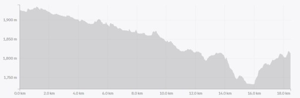
From the Four Points campground, we turned left and followed the trail. At 50 m, we kept right to stay on the Brazeau River valley trail. After 15 km of a mild but steady descent, we crossed the Brazeau River on a narrow bridge. Hiked another 3 km to the Brazeau Lake campground, regaining about 1/2 of the lost elevation for the day.
Totals – Downloadable Tracks on Gaia, Displayed on Strava
Date: August 21, 2025
Group: Two (Alisen & Erin)
Distance: 18.4 km
Elevation: 230 m (759) gained; 332 m (1,095′) lost
Time: 6 hours 08 minutes (includes lunch and breaks)

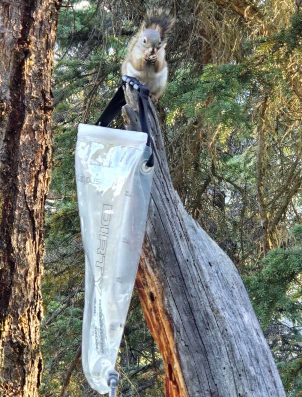
Four Points Campground
It rained on and off all night, with one particularly loud storm that woke me up. Erin and I agreed to a 6:00 am wake up call. Mistake! It was barely light, and absolutely freezing. While Erin was trying to send me subliminal messages to stay in my tent, I was secretly hoping I would not hear her rummaging about and getting up. In the end, peer pressure got us both out of our tents and packing up. Our hands were freezing, and we wore everything we owned. Good thing for a hot cup of tea to get us going, once we got the water filter unfrozen…
The tent fly and ground sheet were soaked, but there was no way to dry them before we left. I separated them out and had them on the outside of my bag to avoid dampening everything else.
At 8:20 am, Erin and I were the first of the three groups to head out that morning. Once we got moving, we were glad for the early wake up. It was going to be HOT and we didn’t relish 18 km in the baking sun.
Four Points to Brazeau River Crossing
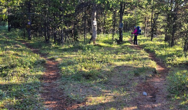
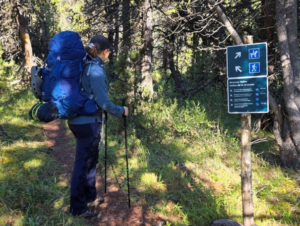
From the Four Points Campground, we turned left (east) on the wide, flat trail. After only 50 m, we passed the turn-off for the Great Divide Trail to Jonas Pass and Jonas Shoulder. We stayed right to keep on the river trail.
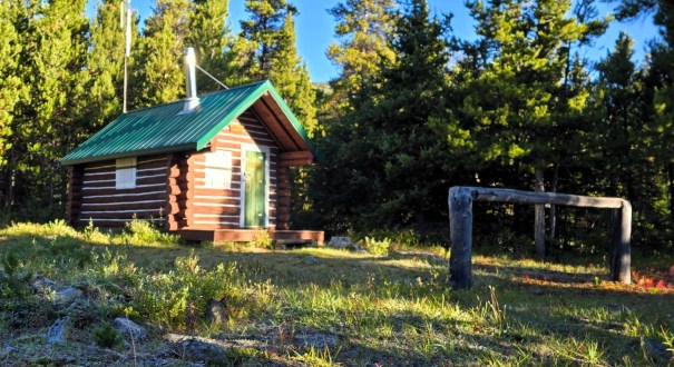
Shortly after that, we passed another Warden’s Cabin on our left. There was a campsite marked on our map, but no evidence of anything.
At 1 km, we crossed a bridge over a creek. It was pretty frosty, and I was glad for the bumpers on either side to keep from falling off.

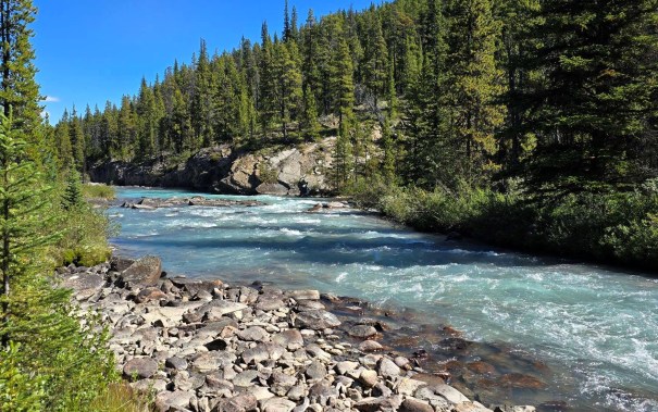
Just past 4 km, we hit a wide washout. We crossed the surprisingly deep stream in two places. I feel like the first crossing location was obvious. For the second crossing, we stomped up and down to find a good spot. Turns out, there is a big yellow diamond on a tree on the opposite bank. When in doubt, look up and across. If you are coming from the opposite direction, there is flagging tape to guide you across. My one boot got wet in the deeper than expected water, but not soaked.
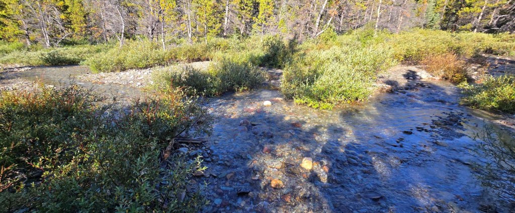

The trail through this section was annoyingly slow. The ground was rooty and lumpy. We were averaging about 3 km per hour, even on the flat terrain. It was impossible to just walk – every step had to be monitored.

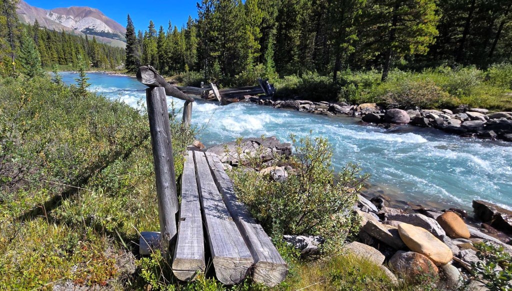
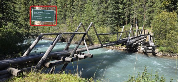
At 4.75 km, we came to a bridge across the Brazeau River. Me thinks we are on the horse trail, and the human trail crosses over. Unfortunately, the return bridge was out, so we had to stay on the rutted trail for a while longer.
Shortly after this point, the horse and human trails finally split. We took the higher road. This was blessedly flat and unrutted, and I finally hiked a bit faster.
Lunch Locations
By 12:10 pm, we had hiked 12.3 km. There was a spot on the map where the trail joined the river. We found a washed out bridge, and used that as our picnic spot. The day had really warmed up, but there was a cool breeze off the river. So nice.
There is another lunch spot just about 100 meters downstream. I am calling Brazeau Beach. It was soft sand on the river bank. This would be a great place to take off the boots and cool down the feet. Maybe splash some cold water if it’s really hot.

Brazeau River Campground and River Crossing
After we left the river’s edge, we hiked back up into the forest. This was glorious. The thick forest canopy kept us nice and cool. Prior to the campground, we went through a boulder field. The photos don’t do it justice, but it looked like the Trolls from The Hobbit had been caught out in the morning sun.

At 15.4 km, we hiked into the Brazeau River Campground. This and Boulder Creek campground are just 4 km shy of the main Four Points and Brazeau Lake campgrounds. If you want some privacy for a few days, these two spots are just as good. Smaller with only 4 spots, and less well maintained, but still an option.
Time to Brazeau River Campground was 5 hours even, and includes our lunch break. Distance was ~15 km with an overall elevation loss.
After a short stop, we continued on to the Brazeau River Bridge. This is a very narrow bridge, and the Brazeau River was raging! I made the mistake of looking down a few times. I think I may have actually squealed. I got instant vertigo from the rushing water seen against the static bridge. Lets just say I don’t get easily freaked. Insane.
Brazeau Lake Campground
After the Brazeau River crossing, it was now time to regain some elevation. Up we went the opposite bank. It felt like we were gaining elevation forever, and couldn’t understand how the lake could be so dang high 🙂

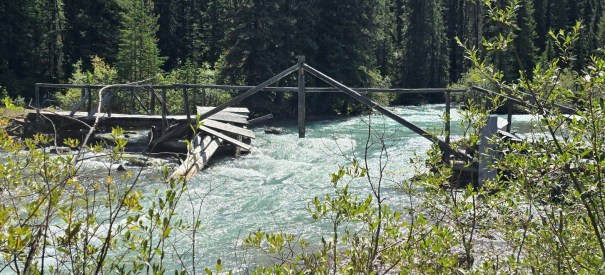
At 17.6 km, we saw the second Brazeau River bridge that was devastated. While both ends were intact, the middle was completely gone. This is the normal passage across the river for the next morning. No matter, we would continue on and see what awaited us at the campground.
Distance to Brazeau Lake Campground was 18.3 km. Total elevation gained was 230 m. Total time was 6 hours, 8 minutes
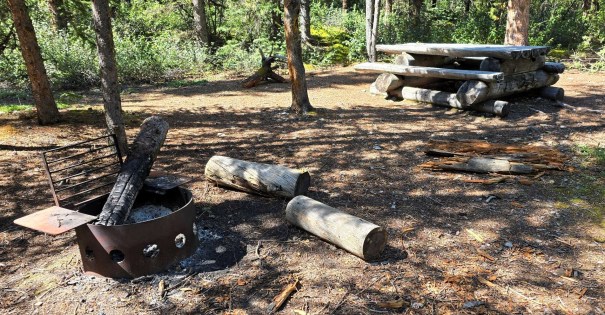
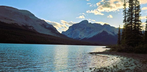
The Brazeau Lake campground is wonderful. There are 8 tent sites, all uphill from the lake. It’s hard to get away from your neighbours here, so just suck it up and pick a spot. There are three big picnic tables with bear bins next to the water.
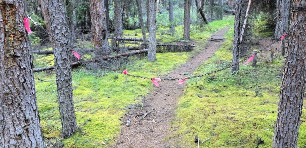
There is only one throne pit toilet that we found, BUT there is a chain to indicate when someone is in the loo. I could see the pink flagging from the picnic tables, and saved myself a long and awkward stand in the forest.
This campsite also features a horseshoe pit. Not sure who hauled in all these heavy things, but it sure was nice.
Brazeau Lake Shore and Lake Crossing
The evening chat was dominated by tomorrow’s river crossing. Our camp buddy Rea has obsessed over this, and watched every youtube video available. She confidently informed us that the crossing was much higher than in the videos. Great.
I studied the river, and came up with a route for the next day. There was one worrisome spot that looked deep, but the silty water prevented a good look.

After dinner, Erin and I walked the lake shore to the west. What a gorgeous lake. It’s way bigger than I thought. This gave us a great view to our trail the next day – the valley between Flattop and Le Grand Brazeau.
Erin and I kept debating our wake up time. We were not happy with 6:00 am because it was so cold and dark, but the crossing would be at its lowest first thing in the morning. Coupled with a predicted very hot day and the most elevation gain for the whole trip, we once again agreed that 6:00 am was the ideal time.

Wrap Up
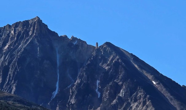
The hike to Brazeau Lake was straight-forward, with very little trail finding or excitement. While the trail was annoyingly slow and heavily rutted, we did get some awesome views of the mountains in the White Goat Area. Mount Marble kept us company on our left all day, and was a great way to track distance traveled.
The lack of a bridge the next morning was a cause for concern, but I was determined to get across.
Click HERE for Day Three on the Brazeau Loop (coming soon).
Thanks for reading! You can follow my blog, join my FaceBook page Al’s Adventurers, or follow me on Instagram
Alisen
I love all things mountains! I live next door to the Canadian Rocky Mountains, however I travel the world to enjoy the many different mountain environments and cultures that I can. I hope you enjoy these trip reports, and that it inspires you to accomplish your own adventure goals.

For the least scenic day of the trip, this is still pretty scenic! The toilet chain is brilliant. The bridge crossing looks very precarious, and the lack of bridge crossing that awaits looks even more so.
I’m not sure I’d have slept for the rest of the trip had something messed with my tent overnight. I’m glad nothing was damaged!
TBH, the bridge crossing was awful. I looked down a few times and the contrast between the rushing water and the skinny bridge…thought for sure I was going to fall off.
The downed bridges are a real concern. Several more were out on this section, which meant we were on the horse trail for a good portion.
I just saw there is a petition to get Parks to properly fund the Parks. Money from park fees goes into general revenue, and not directly back to the Parks. A real shame.
It’s always tough to start the day when it’s chilly. But at least it wasn’t raining (except overnight)! I’m sure the hot cup of tea was nice. Looks like you found a pleasant spot to eat your lunch. Love the concept of thunderbox chain to let people know if it’s occupied. Brazeau Lake looks lovely. Looking forward to reading about day 3 and the river crossing!
Alright – I had to look up Thunderbox!!!! Is this an eastern Canadian thing? I have never heard it called that. I am going to ask my fb peeps to see who knows that.
I love it, and am going to do my darndest to get this into the western Canadian lexicon. Awesome Linda!!!
My only wish for this trip was that it was a touch warmer. I would have gone for a quick dip if it qas hot enough to dry off quickly.
I wonder if the term thunderbox is more of an Ontario thing!
On one hand the cooler weather is better for sleeping and hiking. But, it makes getting up in the morning tougher. And swimming becomes way less appealing!