August 22, 2025
This is Day Three of Five. Click HERE for the full overview, including distances and elevations for each day.
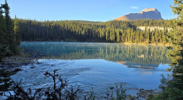
I froze all night, and didn’t get much sleep, but was up again at 6:00 am. It was bitterly cold this morning, and the tents were covered in iced condensation. I again wore everything. The lake was beautiful, with wisps of mist.
Today was a big day! First, I had to wade across the mouth of the river as the bridge was out. Second, this was the biggest elevation gain of the week, and it was going to be hot.
Gear
Full backpacking kit. See Overview page for detail.
Overview
Cross the take at the mouth of the river. Enter the forest and follow a faint but well flagged trail on the peninsula back to the main trail. IF bridge is repaired, then backtrack 400 m to the bridge, and get on the main trail. Hike parallel to the lake until the big washout. Cross the creek, and find the trail into the trees on the opposite bank. Continue up trail between the two mountains to John-John Camp. At the slump, turn uphill to start gaining elevation. Continue around the corner toward Poboktan Pass. Descend into the valley, crossing several bridges as the campsite nears. Take the bridge heading left for Jonas Cutoff campground.
Totals – Downloadable Tracks on Gaia, Displayed on Strava
Date: August 22, 2025
Group: Two (Alisen & Erin)
Distance: 16 km
Elevation: 653 m (2,155′)
Time: 6 hours 7 minutes (includes lunch and breaks)


Lake Crossing to Main Trail
The big debate was how to cross the lake. I scouted a line that was just right (upstream) of the ripples. I was leery of the flat water that would be deeper. How deep, I couldn’t tell from above.

Following the the wisdom of fellow backpacker Sheila – who swore she did this last time she crossed – we decided to strip down to our underwear, in case of deep water. This might have been a joke played on us, but if so, everyone kept a very straight face 🙂
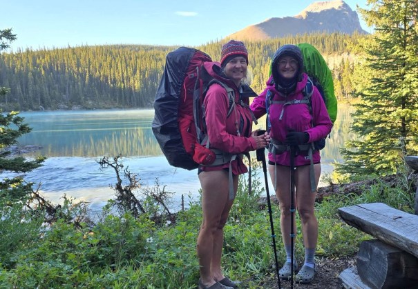
Once we were packed up, Erin and I steeled ourselves and stripped down. We looked ridiculous with our toques and down puffies, with bare legs and crocs. We took the short trail down to the lake. I immediately plunged into the water, and took my route across.
I was thankful for several things:
- the water was warmer than expected
- the water, while silty, was clear enough to see the lake bottom as I walked across
- the water was slow moving
Once I realized the crossing was doable, I enjoyed it immensely. I hustled across the lake in no time, grabbed my micro-fibre washcloth to dry off, got dressed, and booted up. Despite being dead-tired this morning, the dip woke me right up! The entire lake dickering took 20 minutes. If and when the bridge is repaired, it will be faster to backtrack the 400 m to cross.

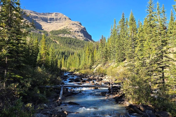
The next challenge was bushwhacking the peninsula to regain the mail trail. This trail was well flagged, and I easily followed previous footprints. I have to say, it was beautiful up here, with the river raging on our left, and the peaceful lake on our right.
We regained the main trail, which was marked with double-flagging. I imagine this is for the benefit of hikers coming from the opposite direction.


Main Trail
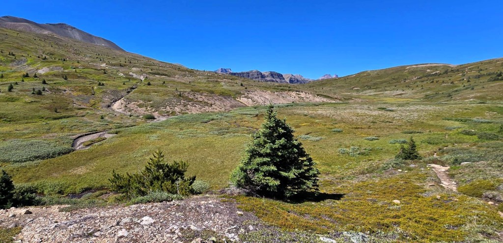
We now hiked parallel to Brazeau Lake, traversing across the base of Flattop. It was a tight forest infested with spider webs. Erin and took turns battling the surprisingly thick strands. Unfortunately, there is nary a view of the lake, so I was glad I took a few pics from the peninsula.
At ~3.5 km, we passed a wide creek washout. We crossed, and found the trail that was straight across. The sign made it look like going straight up the creek bed was the route.

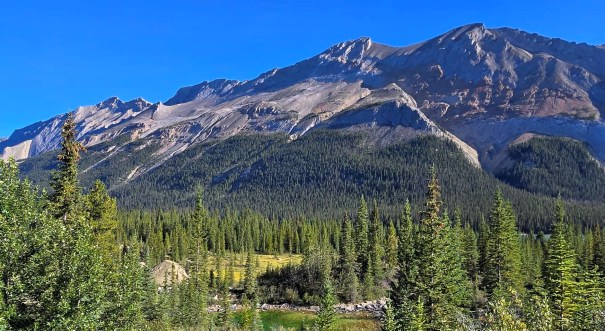
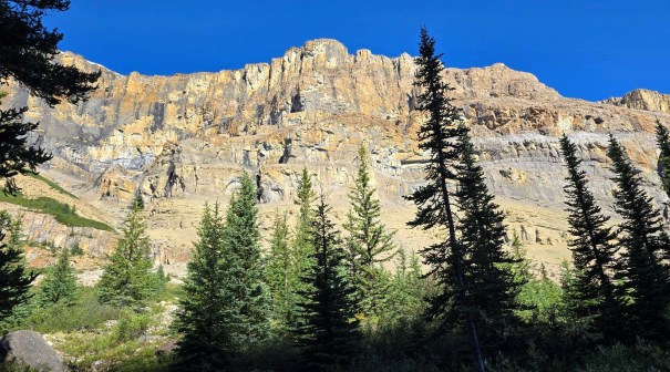
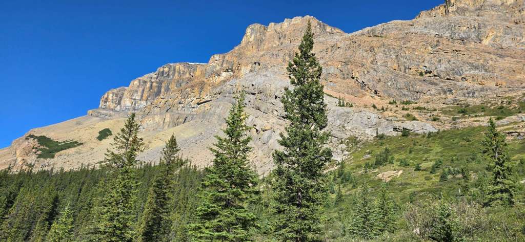
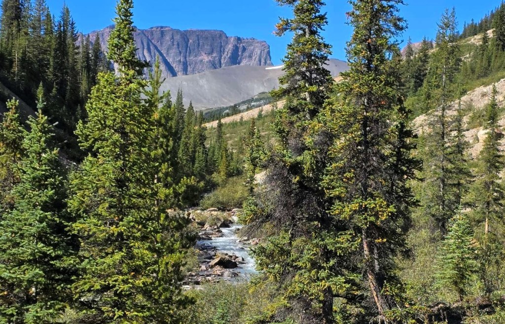
We hiked beside John-John Creek, gradually gaining elevation. We had glimpses of Flattop (L) and Le Grand Brazeau, but looking back gave amazing views. Click to see enlarged views.
At 8 km, we hit the small 4 site John-John Creek campsite. I didn’t want to carry a lot of water up to this point, knowing there’d be a creek here to refill. With the smoking hot day ahead of us, I was worried about dehydrating. We hiked down to the water, but decided we both didn’t need a top up, and continued on.

Poboktan Pass
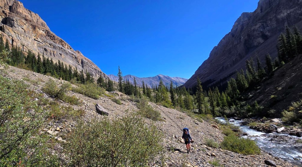
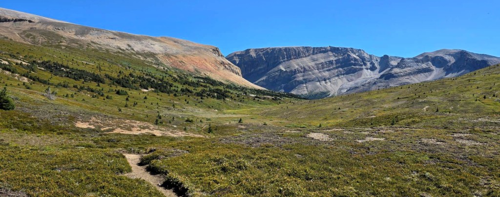
At the 9 km mark (1 km past campground), we hit a slump in the trail, and traversed uphill. This marks the beginning of the good stuff – both the steepest elevation gain and the best views.
As we turned the right corner of Le Grand Brazeau, the vista before us…no words! So much to see and admire. We nicknamed the long mountain in the back “Le Grand Chateau,” not realizing that we would hike along the backside of this mountain tomorrow.
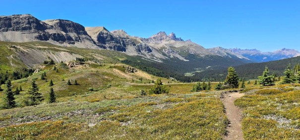
We stopped short of the Poboktan Pass to eat our lunch with this magnificent view.


At 12.5 km, we hit Poboktan Pass, and marveled at the vast high plateau. It was here that I heard a faint “Woo Hoo” from across the valley to the west. Unknown to me, I was looking right at the Jonas Shoulder notch, and was hearing another hiker who had just gained that ridge. We’d meet later in camp.

Jonas Cutoff Campground
After Poboktan Pass, we slowly lost elevation through the vast plateau. This enjoyable stroll was ruined by the meanest little black flies that relentlessly attacked us. Every bush we hiked through was an invitation to get bitten by these tiny buggers. We finally lost them as we got off the flat plateau and into the steeper forest.
As we descended to valley bottom, we followed the trail closely to stay on the correct side of the creek and catch all three bridges.

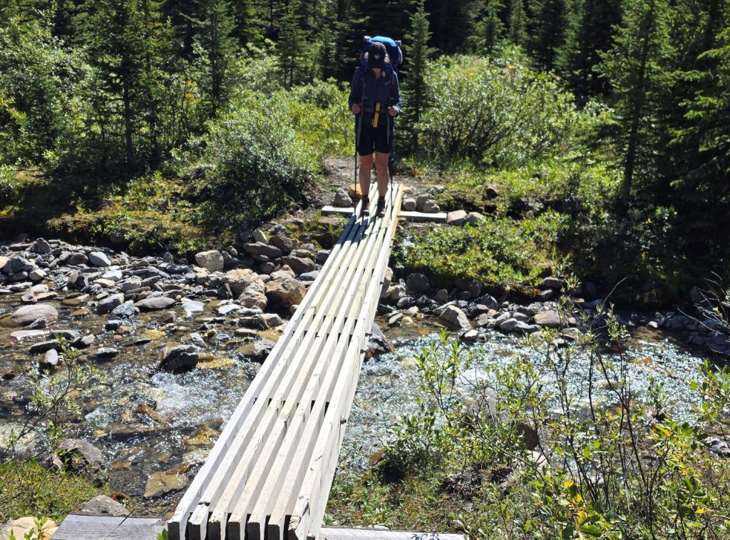
At ~15.5 km, we left the main trail and took the bridge on the left to access Jonas Cutoff Campground. It was a short uphill into camp.

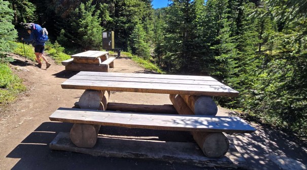
Four Points Campground
This is a long and skinny campground, running parallel to a gentle creek.
Distance was 16 km, elevation was 653 m, and time was 6 hours.
The campsite has the picnic tables and bear bins next to the water. Uphill and straight back (parallel to creek) are the tent sites. During the heat of the day, I put my tent next to the creek in an effort to cool off. By dusk, the air was freezing. Erin and lifted my tent and moved it to the other side.
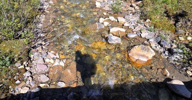
The BEST part of this campsite is the creek. It has a gentle flow, with a smooth rock bottom. There are several little pools to wade into. This was fantastic for soaking my tired and sore feet. Erin and I decided it was time for a wash. With our biodegradable soap, we cleaned ourselves, and gave our shirts and bras a much needed rinse. We were glad for the early start and quick hiking, as we had hours in camp to enjoy the sun and water.


The Jasper triple throne (sigh) outhouse is at the far back of the tent sites, on the left, and up a rather ridiculously steep hill.

Wrap Up
Today was such fun! A cool dip in the lake, followed by the most beautiful views of the trip so far. We were told tomorrow would be better, but we found that hard to believe. The Jonas Cutoff campsite is fantastic, especially in hot weather as we really enjoyed that creek. It would be another very cold night, but that’s the trade-off for clear blue skies during the day.
Click HERE for Day Four on the Brazeau Loop (coming soon).
Thanks for reading! You can follow my blog, join my FaceBook page Al’s Adventurers, or follow me on Instagram
Alisen
I love all things mountains! I live next door to the Canadian Rocky Mountains, however I travel the world to enjoy the many different mountain environments and cultures that I can. I hope you enjoy these trip reports, and that it inspires you to accomplish your own adventure goals.

⬻𓂀ღ☆∞♡ 🔺 𝒽𝒶𝓅𝓅𝓎 𝒻𝓇𝒾𝒹𝒶𝓎 🔺 ♡∞☆ღ𓂀⤖
💚
I couldn’t help but laugh at the picture of you guys without your pants on. I’m getting cold just looking at you! But glad to hear that the river crossing went well and that the water was actually warmer than expected. The triple throne thunderbox looks awful! And it also gave me a laugh. Like who thought that was a great idea!?
I know!!! I think I was more brave in posting that photo than actually crossing the cold and unknown water 🤣😜😂
Triple Thunderbox!!!! Love it!!!
My buddy just visited Jasper NP for the first time and was also – what the actual….??? It’s only found in Jasper. They are requesting feedback right now, so that’s #2 on my list. #1 is fixing the bridges.
Okay well first of all, brrrr. And then eww on the spider webs. And then lovely scenery. And then ugh on the toilet. I’ve never seen one like that, but no thank you. I’d rather go in the woods than go with friends or strangers. And now that I write that, I can’t decide whether friends or strangers would be worse hahaha…
LOL! I know! The consensus is no sharing. The reason there are three barrels is they cannot dig a pit toilet because the camp is too close to the creek. So they put in extra barrels so when one is full, you move on to the next.
Jasper is asking for feedback right now, and I have a few suggestions for the Triple Throne dilemma.