March 20, 2020
Mount McGillivary is a giant of a mountain that everyone sees, but no one notices. That’s because you curve around its massive base as you drive towards Banff from Calgary. On the east side is Lac des Arcs and a twisty road, which usually takes all your attention.
I considered climbing Mount McGillivary, but it is a technical and difficult scramble, with a low likelihood of success. So I was very pleased to discover that I could explore the canyon below!
We need to thank the local Bow Valley climbing community for putting in this trail and the infrastructure. Please do not abuse their equipment, ropes or ladders. If hikers abuse it, the climbers will remove them.
Gear
I did this hike in winter, which is the best time if you are not a climber. It can also be done in the summer, but be prepared for more challenging obstacles and the possibility of getting wet.
For clothing, remember that this is a canyon with little to no sunshine to keep you warm. Plus, there is some standing around while you wait your turn going up the canyon obstacles. I wore long underwear, and soft shell guide pants on my legs. Upper body was long underwear, wool sweater, vest, and gore-tex jacket. I also had a microdown in reserve. As it’s a short hike, I elected to not wear my heated socks, but my feet did get cold despite wearing my Boot Gloves over my boots. I wore microspikes for traction.
Overview
Access to the canyon is straightforward. From the parking lot, start at the trail head. Turn right at the Y junction to follow a cut line. Keep your eye out for the left turn into the forest. Follow this trail until you hit the water crossing, then turn left up the creek. Go as far as you want. Most people turn around at the chock stone. There is an alternate return route that avoids most of the canyon. This is helpful for getting back safely, and avoiding line-ups if people are coming up the trail towards you.
Trail Head
The parking for this trail is on the west side of the TransCanada Highway. If coming from Calgary, do not cross the highway. Instead, simply go the extra few kilometres and take the Dead Man’s Flats overpass to safely backtrack. The parking lot is unmarked, but it’s the only turn off prior to Lac des Arcs. This is an unofficial trail, so there are no facilities or signs.

The trail head is marked by a big boulder, no doubt placed there to discourage people driving up the trail.
The trail head is blessedly obvious even when unmarked. Simply walk straight towards the mountain and enter the forest. After about 100 metres, there is a Y junction. Go right.

The Y Junction is marked. Turn Right. Even if the sign is buried, it will still be obvious to go right here.
Main Trail
You are now on a cut line that parallels the highway. The traffic noise is very loud here, but don’t worry, it will soon disappear.
Thankfully this straight line trudge is very short.
After about 200 or 300 metres from the trail head, turn Left into the forest.

This Left turn into the forest was not marked, other than the beaten down trail. I imagine it’s as obvious in the summer as well. If you are the first one here, it’s the first and only left hand turn.
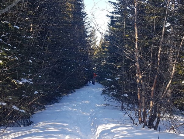
Follow the trail straight towards Mount McGillivary until you hit the creek crossing. There are several ways down the steep embankment, so pick your route.

Mike and Mackenzie when straight down, which did not appeal to the rest of us. We went 6 feet to the right, and found a lovely trail that gently went down to the creek bed.
Once across the creek bed, turn Left to head up the narrow canyon. This is where the fun begins!

Entering the canyon! We just had a massive dump of snow, which added to the beauty of the area. Even in March, you can see that we will lose our sun the deeper we get. Dress appropriately.
The views through the canyon are amazing. I absolutely love being down at the level of the water, instead of admiring it from above. Tracing the water lines, and playing in the cutouts made by ages of swirling water is fascinating.
Avalanche Danger
Before we get too far – a word about overhead environments in the winter. Canyons are terrain traps for avalanches. There is a giant mountain loaded with snow above every canyon in the mountains. If you do not know the terrain above you, be wary about entering a canyon in the winter. Just because someone else did it with no problems does not mean that it’s 100% safe. This is especially true after major snowfalls, or in the spring when the snow is melting (and avalanching!) off the mountain.
McGillivary Canyon
The start of the canyon is amazing. You are guided forward by towering limestone walls on either side.

Not sure where the summer trail is. Perhaps the water doesn’t fill the entire width.
Being at the base of the canyon allowed us to have fun exploring the cut outs made by centuries of swirling water.

This is just one spot. There is loads to explore. Above Mackenzie is the summer trail rope.
As this area is accessed mainly in the summer, there are several places where the trail heads up out of the water course. We played around climbing some of these, but otherwise just ignore and continue straight down the base of the canyon.

A side trip in the winter, it is essential in the summer.
Once you enter the narrowest part of the canyon, the obstacle course begins. Be prepared for ladders, ropes and chains. Again, be kind to the equipment. When using the ladders, do not ram your cleats into the rungs, as that will destroy the wood. It is possible to step on the ladder rungs and avoid making cleat marks.
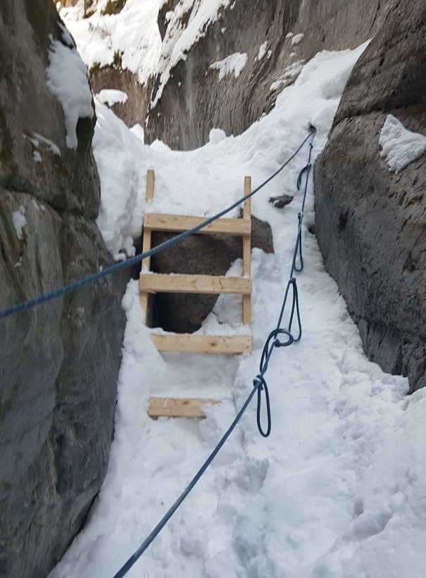
The first ladder is easy in the winter, but it looks like you have to traverse across to it in the summer.

The second ladder is easily accessed, especially with the fresh dump of snow, we could walk right up to it.

The third ladder only gets you so far, and then you have to haul up on the chain.
We all had small black gloves to use on the chains, or else used bare hands for grip. We also carried big fleecy mitts to warm up our hands after the climbing was done. I had emergency Hot Shot heat packs in my pack just in case.

Kayla gives her sister a little Bum-Boost to get over the hump. The new snow meant we could walk right up. On low snow days, you have to shimmy up the log.
The next few sections require some upper body strength, and a little bit of climbing experience to make it up.

Kayla is making her way up. First, you go up the log, then transition over to the rope. At the top, you need to reach for a good hold to bring yourself up.
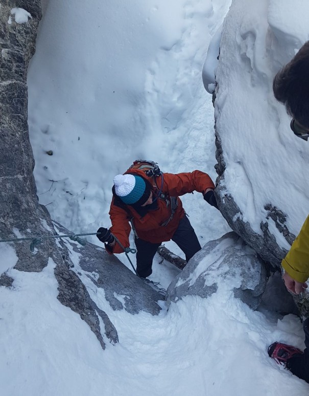
This is Annette coming up that same section. There are hand holds on climber’s left, but at the top you reach to the right.
These last two are the hardest.

Mike and Mackenzie went up the right, but Kayla, me and Annette went up the chains on the left. It’s a combo of getting a leg up to stand on, and hauling yourself up.

The final obstacle requires a lay back move that Kayla is demonstrating perfectly!
Once above this final section, you are back out onto the wider canyon and can enjoy the views.

It is once more an idyllic canyon walk.
The Reason the Trail is Here – A Geology Lesson
You may be wondering why climbers would want to come to this area. It’s because of a giant vertical limestone wall.
This is a bit of an anomaly in the Rocky Mountains, but not unheard of. The most famous wall is of course Mount Yamnuska.
This wall was made many billions of years ago, under the water. This whole area was ocean floor, and was built up as layers of sediment settled on the ground. Some layers were harder than others.
When British Columbia unceremoniously crashed into Alberta, it formed the Rocky Mountains. The impact caused the ocean floor to buckle up, and form the Rocky Mountains. This type of mountain formation is called slip fold. The type of sedimentary rock is limestone.
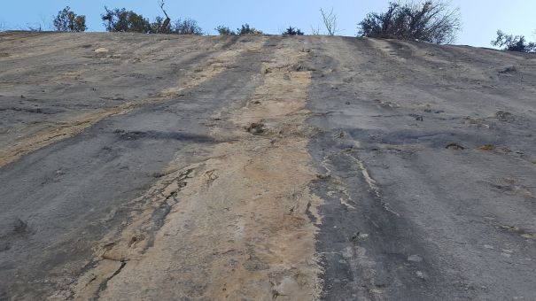
The wall is here because this once horizontal layer was stronger than the layers above it. Over time, the layers above crumbled away, exposing this now vertical layer.

This photo shows the hard layer of the wall on the right. The less strong layer on the left has not adhered to the stronger layer, and is crumbing away from the wall.
The vast majority of the limestone in the Rockies is crumbly like the layers on the left, which is why climbing here is so difficult.
The Chock Stone
From the climbing wall, continue on towards the end. You’ll know it’s the end because of the giant chock stone. This would have tumbled down from Mount McGillivary many years before, and just so happens to fit perfectly into the V of the canyon wall.

This chock stone is massive! It’s also visually appealing. I love how the shape matches the canyon opening.
This is the end of the hike. We did try and continue on for a ways, but there is no trail and Mike was post-holing up to his waist.
McGillivary Canyon Return
Turn around at the Chock Stone and make your way back to the start of the Obstacle Course. If people are coming up, then please consider taking the forest route back home. This allows for one way travel up through the canyon, and speeds everyone’s travel. This is especially important in the winter when standing around is not desirable.
At the top of the final obstacle (the one with the lay back move), go right and follow the trail that takes you up and out of the canyon. Follow the forest trail back to the main trail just above the creek embankment.
As we were the only ones out that day, we elected to go down the obstacle course. This means I do not have tracks to take the alternate back, but it’s easy to find. Please be aware that down-climbing can be harder for some people than going up.
If you found this post useful, please do me a huge favour and click the Star button to “Like” it. You can also follow my blog, or head on over to Facebook to join my page Al’s Adventurers.
Alisen
Totals – Tracked on Strava
Date: March 20, 2020
Group: Five (Alisen, Mike, Kayla, Mackenzie and Annette)
Distance: 6 km
Elevation: 226 m (746′)
Time: 2 hours 15 minutes

The TransCanada highway wraps around the foot of the Mount McGillivary. Lac des Arcs is on the east side. It’s only the first 300 or 400 metres when you are close to the road.

Don’t let this elevation profile freak you out. It’s very little elevation gain. It just shows poorly here because the trail is only 3 km one way, 6 km return.
I love all things mountains! I live next door to the Canadian Rocky Mountains, however I travel the world to enjoy the many different mountain environments and cultures that I can. I hope you enjoy these trip reports, and that it inspires you to accomplish your own adventure goals.

We’ve climbed on McGillivary several times, but have never done the canyon route. It looks like fun, thanks for posting.
Glad you liked it. Good for you on climbing McGillivary!
Lovely post Madam..!! The graphs and numbers though went above my head.. 😛
Well, the young fold Mountains of this World like the Himalayas, the Rockies, the Cordillera Andes or the Alps were once the very ocean floor only, comprising of sedimentary rocks. Thanks to Plate Tectonics, these rocks “folded” and gave rise to such mountains, which primarily comprise of sedimentary rocks only.
This particular trail of yours seems quite treacherous and risky, considering the narrow pathways and steep climbs. The presence of ice in some locations (sort of I-shaped valleys) make the trail even more unsafe as you don’t know what lies beneath the ice covering the I-valley (the base of the ice may even be hollow). I remember such a small valley (was a steep V) covered by ice on top, but had a mountain river flowing underneath the same, in the Himalayas. That was however visible, and I refused to venture to that location (it was damn beautiful though, and Ice is always beautiful ❄❄❄❄❄❄❄ ❤ <3)
Loved this post Madam.. Your articles seem to be pulling me to pay a visit to Canada and explore the vast stretches of Ice.. ❄❄❄❄❄❄ ❤
Yes, you are absolutely correct. There are indeed lots of dangers on this trail. I am thankful that you pointed them out. Generally, I leave it up to people to assess their own comfort and safety levels. I try and not do the whole “Well, I did it, but it’s probably too tough for you” thing. You were right to assess the deep canyon and water flowing in the Himalayas as dangerous, as there is no doubt way more water flowing there. Alberta is a pretty dry place, so our water levels are not as high. That being said, I have skied several canyons where water was flowing, and I did have to be extra cautious to not fall in. Thankfully, that was not here, at least not at that time of year. Thank you for sharing your Himalayas experiences. You have lived an exciting life, my friend.
By all means – come visit the frozen landscape that is Canada. This was a particularly good snow year. Some years we barely have any snow at all. If you want guaranteed snow, then you’ll have to go further north to the Yukon.
Thank you Madam for your warm welcome to your beautiful Canada.. 😊🤗
Noted your point about Yukon. Sounds pretty mysterious to me, but that’s what life’s purpose should be – to dig the answers out.. 😊😊
Well, I have lived only a fraction of excitement life has to offer.. The world is huge and there are lots of excitement and adventures up for grabs.. 😊🤗
You are most welcome to visit the abode of Ice in India – The Himalayas.. 😊🤗 And yes, we have tea as well.. 😉