November 2nd, 2023
On our first day in Nevada, we picked up our campervan and headed straight to the Red Rock Canyon campground. The next morning, we were up and ready to enter the park at our pre-booked Timed Entry. Unfortunately, I could not find the reservation email for anything. That’s okay – the kind guy at the admission booth looked up my email, found me, and let me in. So nice!
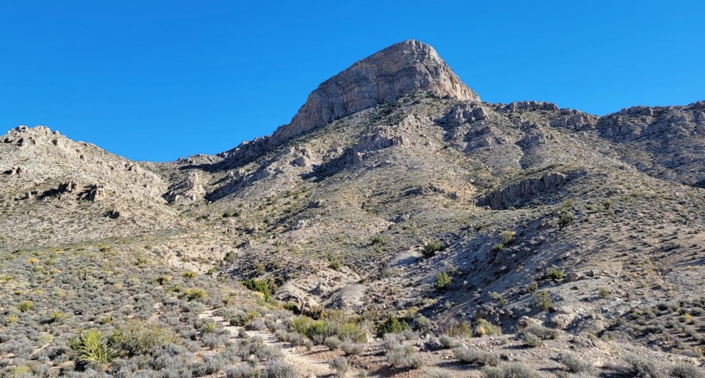
We headed straight for the Visitor’s Centre for some intel. I had about two days to book this trip, and had zero time for research. That’s okay – the Visitor Centre guy was great. I asked for the longest, hardest hikes they had. His advice did not dissapoint! He recommended we head immediately to Turtlehead Peak because there was no wind and it was doable today. We are no strangers to wind, but thought we’d heed the advice we asked for, and head on up.
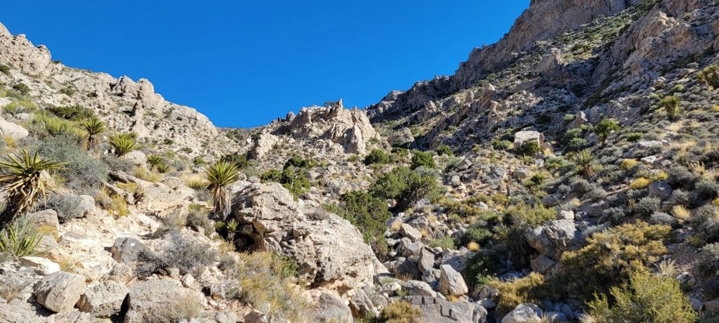
We saw lots of people on the official trail. Several people who started before us were coming back down, not liking the heat and the elevation gain. Most desert hikes are fairly flat canyon bottom walking, but this is a true hike.
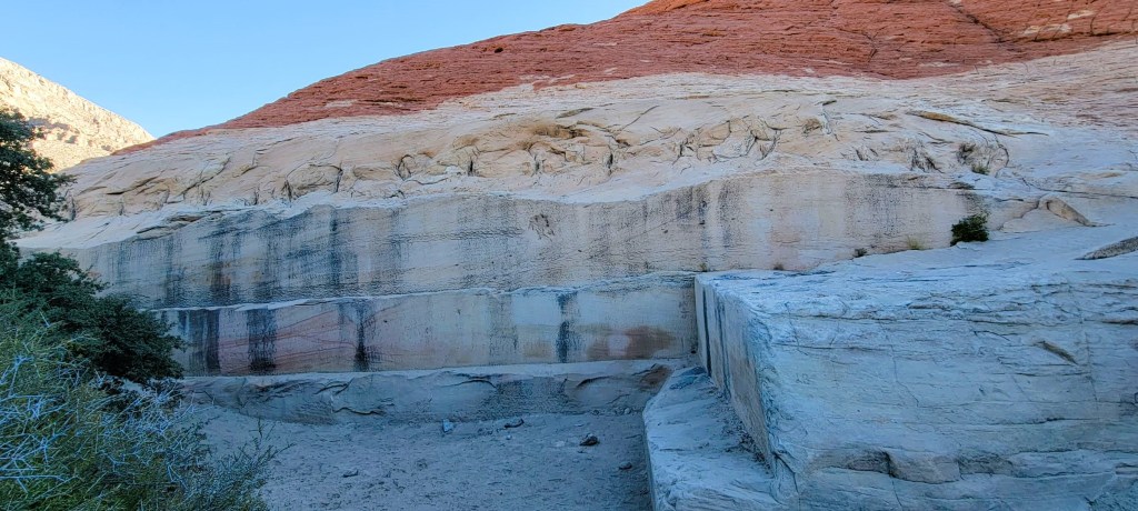
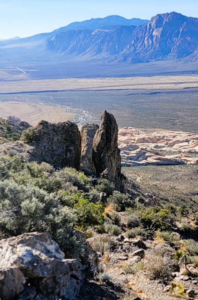
Geologically, this is a special feature called the Keystone Thrust. About 65 million years ago, an older and deeper limestone layer was pushed up and over the younger sand dunes.
Gear
Hiking boots, poles and regular day pack kit. Lots of water!
Overview
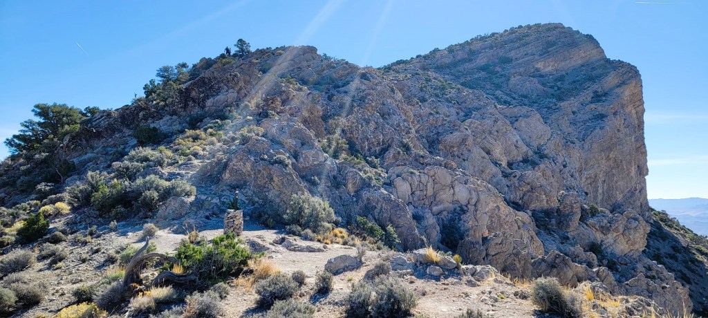
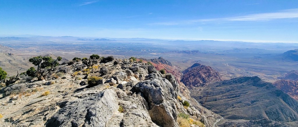
From the parking lot, follow the signs through the sandy desert floor to the base of Turtlehead Peak. Start hiking up, following the barrels of rocks used as trail markers. At the col, this is the end of the official trail. To continue to the summit, turn right and make your way up any old way you choose. There are a million paths at this point. From the summit, we enjoyed the view, then hiked down the way we came.
Totals – Downloadable Tracks on Gaia, and on Strava
Date: November 2, 2023
Group: Two (Alisen & Mike)
Distance: 7.4 km
Elevation: 600 m (1,980′)
Time: 3 hours 40 minutes (includes breaks)
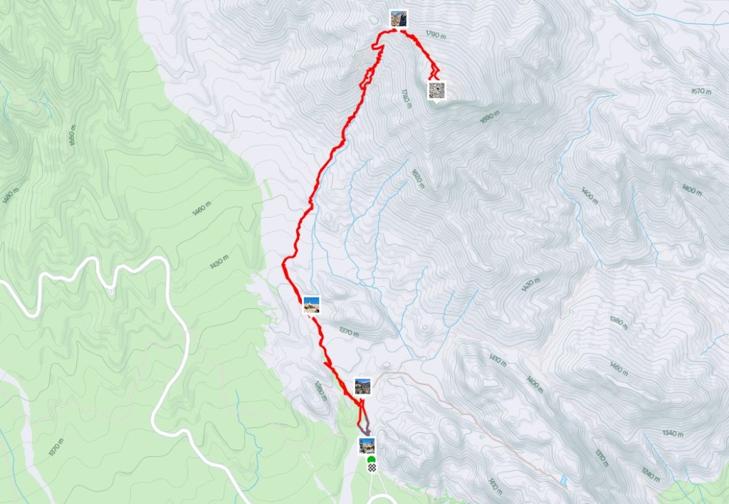

Parking and Trail Head
The parking lot for Turtlehead Peak is, I believe, the third parking lot on the scenic drive from the entrance. The trailhead is well signed.

Main Trail
We found the trail to the base of Turtlehead Peak a bit convoluted, especially for our first foray into the area. There are lots of other trails, many of which are dead-ends that lead to technical climbing routes. By keeping and eye on the Turtlehead Peak, it’s fairly easy to pick the right trail.
There are trail markers, and we also had GPS.


After a little more than 2 km, we were at the base of Turtlehead Peak. From here, we followed the trail and a series a cairns to the col. The cairns were barrels of rocks wrapped in chicken wire. While this used the available landscaping material, they were sometimes hard to see because they were the same colour as the landscape.
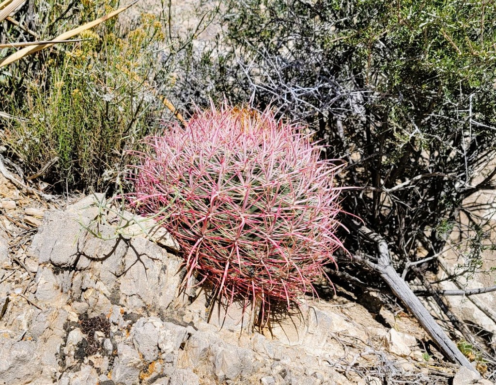
One of the best parts of this hike was the amazing desert flora. I’ve never seen anything like this.

We saw a few people on this trail, most of them were coming back down. They were not happy with the heat and the elevation. Once we got to the col, we saw one couple heading for the summit, but we never saw them on the trail.


Return
After enjoying the summit views and having a snack, it was time to head back down. We retraced our steps back to the col, where we met a father / son duo from the midwest. They immediately clocked our Canadian accents, which was pretty impressive considering we really only said hello at that point.
By the time we got back to the campervan, it was about 1:45 pm. I was SO hot! I crawled into the van, stripped off my clothes, and drank a gallong of water. I eventually cooled off enough to begin thinking of heading back out. So glad I did, because the Calico Tanks were pretty darn cool.
Thanks for reading. Have you hiked Turtlehead Peak? Or is is now going on your list? Do tell.
Alisen
I love all things mountains! I live next door to the Canadian Rocky Mountains, however I travel the world to enjoy the many different mountain environments and cultures that I can. I hope you enjoy these trip reports, and that it inspires you to accomplish your own adventure goals.

We hiked it back in 2001 – before they installed the wire basket cairns. Solid hike, stunning views! Great pictures on your part. 😊
Oh, interesting. I actually thought the wire basket cairns were difficult to see because they sit on the ground, and the background is more rocks of the same colour. A regular cairn would sit on the highest point, with sky behind. This makes them more visible from below.
I agree that it’s a solid hike, especially for that area. Any other favourites for you in Red Rock?
We did the White Rock Loop in 2019. Easy trail, little climbing, great scenery. One we haven’t done is Bridge Mountain – which is described as an obstacle course of a hike with real Class 3 sections. It’s probably the hardest “hiking” route at Red Rocks.
Oh? Good to know. I love a good obstacle course and some scrambling. My friend’s have climbed in Red Rock, and the rock looks amazing. I’ll have to bring gear next time I go. Thank you SO much for that recommendation.
Phew! Glad they were able to look up your reservation in the system! This looks like a scenic hike and the views from the col and summit are beautiful. I’m a huge fan of the desert plants as well. It’s so different compared to anything we have back home in Canada.
Everyone at Red Rock was SO nice and helpful. I find that to be the case in most US places, but they went above and beyond.
Glad to hear. We normally inquire about the trail conditions and ask for suggestions when travelling in the US (and Canada), even when we’ve done our own research. They have the most up to date information. But agreed, not all people or places are friendly. Reading about your hikes really makes me want to go back to Nevada. We had such a fabulous time when we were there in January 2023.
I think it’s time for me to go back too 🙂 The snow just hit, and while I love it, a quick hit of sunshine and warmth is also a good thing.