May 21, 2025
I took advantage of a rare 48 hour layover in Iceland to visit as many locations as possible. My husband and I spent the prior day touring the Golden Circle. Today, we ventured further afield.
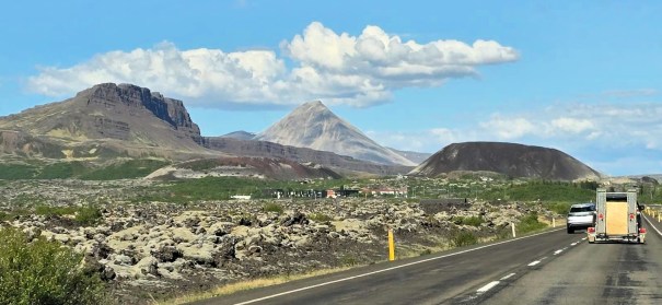
After we explored a massive Lava Tube Cave. we now wanted to see a volcano from the outside. We drove to the small town of Bifröst (no relation to Asgard’s Rainbow Bridge 🙂 ). Here we hunted up some ancient craters at Grábrók.

Roads – Tunnel, Bridge and Signs
Driving to this area from Reykjavík is pretty darn cool. We traveled north, and took the Hvalfjörður Tunnel. I saw the large water crossing on the map, but didn’t realize we’d be underwater for five minutes! I’ve been in several tunnels in Austria and Türkiye, but I think this was my longest. The walls of the tunnel swap between smooth concrete slabs, and what looks like rough-hewed stone. It’s an engineering marvel for sure.

We made a loop driving first to the Lava Cave, and then back down to the craters. This meant we got to drive over a sea bridge at the town of Borgarnes on our way home. We took the tunnel back to Reykjavík, which I have to say, was just as exciting as the first time.

One of the funniest things we saw were these maps on the road. The speed limit is 90 km, and they do not encourage you to slow down. I pulled over at one point to try and read this map. It looks big here in the photo, but trust me, it’s impossible to read (or understand!) at highway speeds.

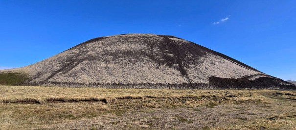
Grábrók Crater
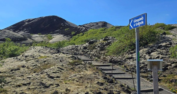
Grábrók Crater is three separate craters that formed over 3,000 years ago in a fissure eruption. Fissure volcanoes are common, and occur near fractures in the crust. This fissure is 600 m long. Unfortunately, the smallest of the trio no longer exists, as it was mined down several decades ago. The middle crater shows initial signs of being mined, but the government stepped in. It is now preserved as a national historic site.
Hiking is only allowed on the largest crater. They have a beautifully set trail, and ask people to please respect the environment and stay on the trail. There were a few cars in the car park, but only one other group on the crater. The hike up is a bit stiff, mainly due to the stairs instead of switchbacks. Once up top, the trail loops around the entire rim for a full 360 degree view.
We looked over to the second crater, and saw a trail heading up. We did explore the base of this crater, but saw several signs asking people to not hike up. I’m all for exploring, but I am more for respecting boundaries, especially in other people’s countries.


Old Brekka Sheep Corrals
From the top of the biggest crater, we saw two sets of low stone walls. Super curious, we walked over to the closest area. This turned out to be sheep corrals that were used in the 19th and 20th centuries.
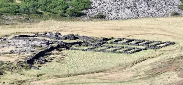
The sheep corrals were built by stacking the lava stones. The first was built in 1831, and was used for 40 years. At the end of the season, the sheep would be collected up, and held in the pens waiting for transport. Unfortunately, it was near the river, and sheep were lost during a very large flood.
The pens were then rebuilt further east in 1872. This site was also impractical, as the middle pens were down-sloping. The sheep in these pens were in danger of being trampled. The sheep farmers were not to be bested. They re-routed the river, and re-built the sheep corrals close to the original site. In 1964, this area was listed as an archaeological site.

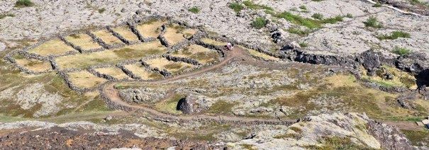
After exploring the first set of pens, we walked west around a small hill, scattering several sheep. We explored the original corral site. The ground here is very uneven, with ‘pot holes’ concealed by the long grass and mossy ground. I’m interested to know if this was caused by porous lava?


After visiting the pens, we hiked to the base of the medium sized crater. Around the back, signs of mining are clearly visible. They didn’t get very far, thankfully.
We then walked between the medium and largest craters, to where the smallest crater would have been. Several large boulders were left over from the mining, and were pushed together into a pile. We continued on, and ended up on a road. This lead us back to the main parking lot.
I loved our visit to the Grábrók Crater. It’s not every day you can walk on an ancient cinder cone. Plus, we had the added bonus of exploring the sheep pens. We were definitely not expecting that. A real two for one.
All the Icelandic Sights
Thanks so much for joining me on my whirlwind tour through Iceland. Phew! Who knew I could cram SO much into 48 hours.
Here’s all the places I visited. This is just scratching the surface. I will be back, Iceland!
- Reykjavik
- Golden Circle Route
- Þingvellir National Park
- Bruarfoss Waterfall
- Geysir – active geothermal geyser fields
- Bruarhlod Canyon – giants anyone?
- Víðgelmir Lava Cave – impressive lava tube
- Grábrók Crater – ancient craters and sheep corrals
Thanks for reading! You can follow my blog, join my FaceBook page Al’s Adventurers, or follow me on Instagram
Alisen
I love all things mountains! I live next door to the Canadian Rocky Mountains, however I travel the world to enjoy the many different mountain environments and cultures that I can. I hope you enjoy these trip reports, and that it inspires you to accomplish your own adventure goals.

What an incredible whirlwind adventure, Alisen! Loved how you blended history, geology, and humor—Grábrók sounds stunning, and the sheep corrals were such an unexpected bonus. You really captured Iceland’s magic in just 48 hours. Can’t wait to read more!
Thank you so much! That’s it for Iceland. Back to Canada and more climbing there 🙂
That sounds awesome — I bet Canada has some amazing stories waiting too! Looking forward to reading all about your next climbs. Safe travels and keep the adventures coming!
Wow, what a cool place! Thanks for this whirlwind tour of Iceland, I very much enjoyed tagging along for the virtual ride.
Thanks for coming along for the ride Diana. Can’t wait to read about your Icelandic Adventures soon.
I’m impressed at how much you were able to do in your 48 hour layover. Beautiful captures of the volcanic craters. I love how colourful the landscape looks.
Thank you kindly! We were both pretty swacked when we got home, However, this was not our first rodeo. We’ve done a few of these crazy 48 hour trips, so it’s a bit of a science. But yes, we did go harder in Iceland than anywhere else. So thank you for noticing. There, I finally got there 🙂 Sheesh. Hard to take a compliment or what!
So inspiring, I would love to visit one day.💖
It’s truly an amazing place. Stunningly beautiful and geologically interesting. It’s pretty close to you too 🙂
You are right it is pretty close to me…. I think it will happen one of these years. I love geology even though I am such an amateur😃
Yes! I also love geology. I am quite happy to admire it from afar though. There are SO many geologists in Calgary that if I ever have a question, I can ask.
I’ve often thought that I missed out on being a geologist because at the time I went to Uni (early 90s), the oil and gas industry was in a tailspin and no one in their right mind would be a geologist. Ha! Were they ever wrong.
That was fun! 😀
Glad you liked!