August 20, 2019
This is Day two of my three day backpack on the Skyline Trail. Click here to read about Day 1. You can find the final Day 3 here.
The second day on the Skyline Trail was our longest, with the most elevation gain. It was also the most difficult in terms of group dynamics. It’s always hard with such a large group, but even more trying with different fitness and experience levels. My family is very fit, we have done a lot of backpacking and mountaineering (my daughters did a 16 day backpack the year before), and we know what it takes to put a long day behind us. The one Couple was not very experienced, had not been to the mountains at all this year, and one of them was not in shape. The family of three were also in good shape, but the daughter had just come back from six weeks at sea level, which is always a challenge.
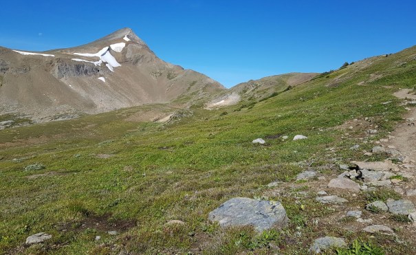
We woke to a brilliant blue sky on the morning of Day 2, packed up and started hiking at 9:00 am. Less than 500 m outside the Snowbowl campground showed us our first objective for the day – Big Shovel Pass. This is a lovely hike with 288 m (950′) of elevation gain over 6 km.
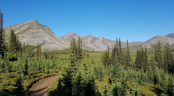
The view of Big Shovel Pass as we left Snowbowl campground. Curator Mountain is in the centre, the furthest away, with lingering snowpatches. The pass is the lowest point on the horizon leading down to the right from Curator.
The scenery along this section is just amazing, with several creek crossings and too many mountains to name. Enjoy this lush landscape because it changes quickly!
The second of two major (unnamed) creek crossings that come off Antler Mountain in the background. If you didn’t fill up with water at the campsite, this is an ideal spot for fresh sparkling spring water.
We were not alone on the trail though. We came across several families of marmots, many of which were not concerned about us in the least.
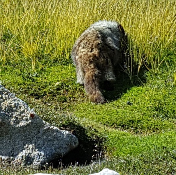
This fuzzy little marmot couldn’t care less as we walked by. They don’t even bother to send up the warning cry as we pass.
Heading up to Big Shovel Pass, we were passed by a few trail runners. I am always amazed by long distance runners, especially those who then decide to throw in several thousand feet of elevation gain, just for fun.
Then we discovered a new type of hiker – tennis shoes, no packs, and no gear. I was greatly perplexed to see people so unprepared, yet so happy about it. And then I remembered there is a lodge on the Skyline Trail – Shovel Pass Lodge!
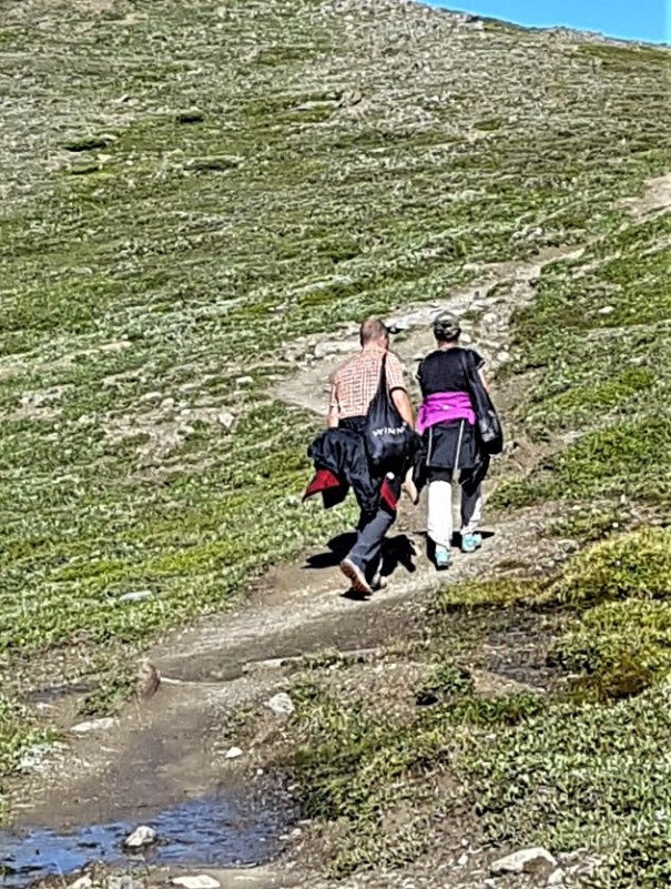
Do not be surprised if you see people on this trail with very little in the way of gear. They are going to the Shovel Pass Lodge. I personally think it’s great that this trail caters to such a diverse group of people. We need places for the casual tourist and the hard core, flea-bitten mountaineer, plus everyone in-between.
Unfortunately, the trail was taking a real beating from all the foot traffic during the heavy rains and snows of this summer. Despite the higher elevation, the ground was still very wet on this side of the pass. Perhaps in the future Parks Canada can put in raised walkways to protect this fragile environment. I know several trails that have this system and it allows the water to flow unimpeded and clear, and the vegetation grows back nicely.

The trail was in really bad shape. Maybe it’s this wet every year? We tried not to braid the trail, and wearing gators really protected our boots and pant legs so we could go through most of the muddy sections and leave the green edges alone.
As we approached Big Shovel Pass, I was definitely eyeing Curator Mountain. As we were only 5 km into a 20 km day, and with all the elevation gain ahead of us (the pass and the Notch), plus the entire open expanse of the Skyline, I thought it best to keep to the plan. If I were to do it again, I might stay the first night at Little Shovel Campground, then hike the two passes, climb Curator Mountain, and then descend to the Curator Campground. As a reward, I would perhaps wander over to the Lodge for a pint to celebrate my summit…
Curator Mountain is looking mighty fine! The moon is just setting to the left of the peak. The trail winds up to the right along the shoulder.
 From Snowbowl campground, it took us two hours to arrive at Big Shovel Pass (2,320 m). The signage says 5.3 km, but Strava clocked in at 5.6 km. Elevation gain was 226 m (745′).
Like Shovel Pass the day before, this felt very laid back, and was very doable for a beginner backpack. Mike and I had all three kids up front with us, but the other adults were showing signs of flagging. It was going to be a long one.
I like how this trail unfolds. You don’t see your next objective until you’ve finished the first one. Hence, we didn’t have to fret about The Notch until after we completed Big Shovel Pass. Forgive me this quick terminology lesson. A pass, a col and a notch are all the same thing – they are the low point between two mountains. A Pass is the most gentle. It is usually a wide saddle, and not overly steep. A Col is steeper and more narrow than a pass. A Notch is the steepest and tightest of the three. As the area was outright called “The Notch” we knew we were looking for a steep mountain ascent. Mike and I scanned the horizon until we found the most likely candidate, complete with cornice in place, and then confirmed it on our map.

The Notch is the snowpatch on left hand side of Amber Mountain. From here, the trail descends to the right, down to Curator Lake. The trail then ascends pretty much straight up from the lake, and pops out on the right hand side of the cornice. The trails to Watchtower (right) and Curator (left) are both ahead.
Continuing on from Big Shovel Pass, we entered what can best be described as a Mars landscape. The ground went immediately from lush, green and wet, to desert dry, red, and barren. The dramatic difference in precipitation from one side of the pass to the other was intense!

The landscape quickly changed to dry and barren. The red colour was surreal – it felt like we were in the middle of a volcano.

There are two trails leading off to the right. If you are unsure, just hike a bit further until you reach this sign. Check out the footprints behind the sign – the ground looks like sand.
A quick one kilometre past Big Shovel Pass takes you to the first junction, which is Watchtower Campground, and further on, to the trailhead. This is one possible ‘escape route’ if you are stuck in a snowstorm, or have just plain had enough. This way leads to the Maligne Lake road, which really only sees tourist traffic. If there is a snowstorm, there might not be many vehicles.
We continued for another 2.8 km of very enjoyable hiking along a slowly descending trail. We were accompanied by a herd of mountain sheep that managed to stay just slightly ahead of us, except for one brave soul who didn’t mind being close to the trail.

Mountain Sheep have come up from the valley below. You wouldn’t think there was much good eating up here, but they seemed to enjoy what they found.
It is only 1 km from the Skyline Trail to Curator campground and Shovel Pass Lodge. We were told by other hikers that the return trip up to the main Skyline Trail is a pretty steep climb, especially first thing in the morning. Make sure you have that celebratory pint to make the effort worth while…
 This is your final escape route off the Skyline Trail, and your best bet. If you are in a big snowstorm, there might be lodging available at the… well, the Lodge. If not, keep going until you reach the Icefields Parkway highway. This road is always well traveled, and you’ll have better success getting picked up and returned to Jasper than the Maligne Lake road. Not that people are not nice on this road, it’s just less busy.

Looking down the valley to both Curator Campground and Big Shovel Lodge. The Icefields Parkway is below and around the corner if you need to exit the Skyline Trail.
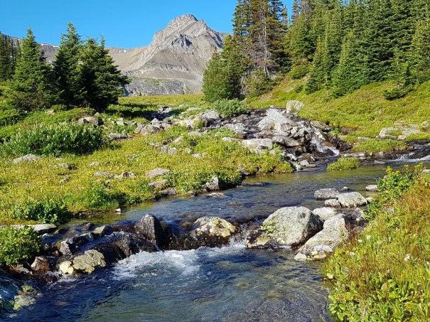
We decided to have lunch at Curator Lake, a gorgeous little tarn with large boulders to lean against. We arrived at 12:15 pm, after about 3 hours of hiking and 8.9 km distance.
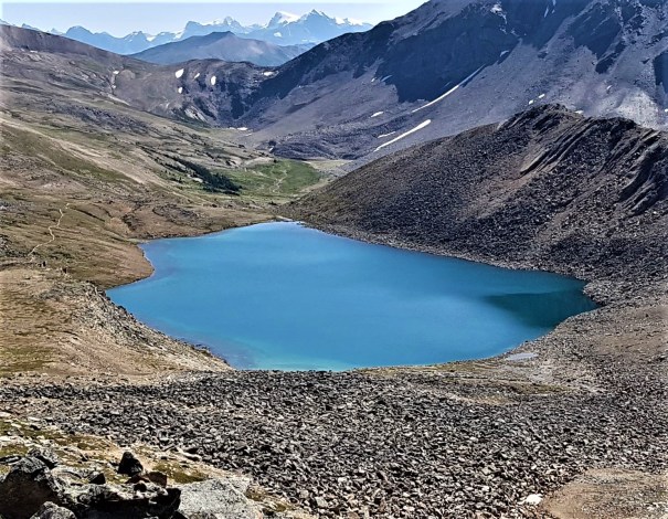
View of Curator Lake from about 1/2 way up The Notch. We ate lunch at the far end of the lake. You can see the trail snake backwards to Big Shovel Pass.
The hike up The Notch is steep but short. It took exactly one hour from the far end of the lake to the top, at a very slow and doable pace to keep the entire group together. The trail up through the scree was in excellent shape, lots of switchbacks to help with the elevation gain, and thoroughly enjoyable.

This is a great trail. I found it easy to navigate, and while the elevation gain was stiff, it was over fairly quickly. I really enjoyed the rock formations on the right, and seeing the terminal moraines from at least two glaciers.
The cornice at the top of The Notch was putting on a fine show for so late in the season. It is rare that you can hike right next to a very large cornice, especially one eroding away so clearly. It’s a sober reminder of why it’s so important to stay well back from snow ledges year round.

This really is a huge cornice. You can see how it extends way out beyond the ground, yet is completely unsupported from below. A reminder of why it’s important to stand well back of snow ledges in summer and winter.

I hope you are enjoying these brand new signs. This one was lying on the ground because the two young Parks employees were in the process of digging a deep hole to erect it. Kudos – they were doing a great job!
Congratulations!!!! The Notch is exactly half way on the Skyline Trail! It’s about 22 km either way to get back home. It is also the highest point at 2,510 m (8,283′). Elevation difference from Snowbowl Campground to The Notch is 416 m (1,372′), but this doesn’t include the elevation loss to the lake. I estimated total elevation gain to be about 496 m (1,637′). At this point, Strava clocked my distance at 11.2 km.

One of many summit shots. THIS is a great way to spend quality time with your kids. We’ve been lucky to hike with our daughters since they were three years old. You’ll see two of us are wearing our knee braces in anticipation of a long and grueling downhill section.
Our group spent some time here, admiring the views, taking pictures, and just enjoying life. We were incredibly blessed with bluebird skies and zero clouds. We met another couple who have hiked this trail four times and this was the ONLY time they had clear weather. So if you are blessed with clear skies, take lots of photos and do a little dance of gratitude.

A clear view of Mount Robson! Don’t take these views for granted. One couple had to do this trail four times to catch this sight.
Tekarra Campground was still another 9 KM away, so Mike and I roused the group to continue. This is the section where the ‘real’ Skyline views happen. It really is hard to imagine how big and epic this three km ridge is. It feels like it goes on forever. Every time you come to a little rise, another expanse opens up before you. It truly is breathtaking.

The Skyline Trail “ridge” seems to go on forever. It’s only about three kilometres, but SO worth the effort to get up here. Thankful for blue skies!
Every step was another incredible view competing for my attention. It was also incredibly windy! I’m glad we lounged in the wind shadow at The Notch, because there was no where to get out of the wind on the ridge.

This is just one of the many amazing views along the Skyline Ridge. The little tarns drain out to Excelsior Creek. On the left is Centre Mountain, and the right is The Watchtower.
Mike was now leading, and he’s an incredibly fast hiker. My kids were up front with him, I was lagging back a bit, but the rest of the group was getting further and further behind. This section seemed relatively flat while we were hiking, but when I look at the elevation profile (at bottom of page), I see that it actually has a lot of elevation loss and gain. This is a great place to make up some time after slow slogs up the two passes.

I didn’t get a picture of the Jasper townsite, but this is Marmot Basin, just around the corner.
What I find so amazing about this trial is how CLOSE it is to Jasper village. Most of the backpacks I’ve done are all very remote, so it was a big surprise when we popped over a ridge to see the town below. It then dawned on me that I was looking up at this very ridge two nights before while strolling through town. I wondered if anyone was looking up at me at that very moment.

Along the Skyline Ridge you will find some large cairns, seemingly at random on such a beautiful day. They are actually here to help you navigate in a whiteout. There were two Parks employees putting in poles along this section to help you get from Point A to B. To give you an idea of how bad the weather can get up here, I have seen photos of full snow whiteouts, and raging hail storms.
This Skyline Trail ridge was like walking on the moon. Zero vegetation, and the limestone was ground down into fine flakes. It truly is unlike any area I’ve been to, and is so worth the time and effort.

Walking on the moon, er, I mean, the Skyline Ridge.
The descent off the Skyline Ridge is a real treat. I realize that may sound snarky, but I mean it. Both my daughter and I have really bad knees, but we found this descent to be gradual enough to avoid any pain and be quite enjoyable.

Our first look at Mount Tekarra. To summit, it is a hike or a scramble, but after a full day I would have to forego this one as well. The Tekarra Campground is still a looong way away. It is nestled in the trees beyond the lake, at the far end of Mt. Tekarra.
Water can be an issue on this section of the trail. The day before I ‘managed’ the water refilling spots, but apparently some people in the group felt I was being a bit bossy. So today I left everyone to their own devices as to when and where to fill up. Each group had their own topo maps, and were busy yelling out names of mountains. If they could do that, I figured they could also tell where the water crossings were (and the lack of water for 80% of the trail!). Apparently not… Along the driest, most barren, and highest section of the Skyline Ridge, I was informed that the other two groups were running out of water. They wanted to know where they could refill. Mike just shook his head, and pointed to the very bottom of the valley, some 8 KM and hundreds of metres below us.
The last place to get water before The Notch is Curator Lake, where you can easily pump and filter water. Considering we lunched on the shore, I thought gathering water here might be obvious. There was also a small spring on The Notch scree slope. I DID mention this as a possible drinking source, but no one took me up on the offer. Even in a group situation, everyone is ultimately responsible for themselves. Lord knows I do not know everything about mountain travel, but you can’t have it both ways. You cannot get mad at someone for getting you to refill your bottle one day, and the next day get mad at them for NOT telling you to refill your bottle. Again, group dynamics were tricky on this trip.
This descent off the Skyline ridge is also very pretty. There are large boulder fields to pick your way through, all with interesting colours and shapes. I could have spent some more time just exploring these rocks.

I just loved picking our way through these colourful rocks and boulders. A bit of colour after the moonscape above was a real treat.
By this time, Mike and I decided that we couldn’t keep stopping and waiting for the others. We were moving at a moderate pace, but the others were getting slower and slower. With heavy packs, and a long day, sometimes you just need to get it done. I felt we had done our best to get everyone up and over the most difficult parts. From there on out, there was no more route finding to do, it was just a matter of slogging along until you hit the campsite. We made the decision to just keep going and snag some camp sites. The others had also made it clear the day before they knew where they were going, and didn’t particularly need us.
We still found time to play around though. There is a massive erratic on the trail, so we stopped to climb it.

Playing on the erratic, with Mt. Tekarra in the background.
We finally made it down to the creek crossing. The vegetation had magically returned, we refilled our bottles, chatted with some more marmots, and continued towards Tekarra campground.

Our first creek crossing since leave Snowbowl Campground this morning. This is an unnamed creek that springs from the side of Amber Mountain. You can see the Skyline Ridge trail far above the girls.
Again, with all the rain, the trail on this lower section was a bit muddy. We left our gators on from the morning mud sludge, and they came in handy again at the end of the day.

Almost at the Tekarra Campground. From here, you enter the trees for another kilometre or so. The campsites are on your right, and the food prep area is straight ahead on the same trail.

Lounging beside the unnamed creek, across from the Tekarra Campground.
Tekarra Campground is another very popular campsite on the Skyline Trail, and I can completely agree with anyone wanting to stay here. The tent sites are up above, while the food prep and storage area is right next to the unnamed creek. We spent several hours with our feet in the water, enjoying the incredible views that some of the other campsites lack. We had a great time relaxing while we waited for the others to arrive and set up their tents.
Again, the campground is located low enough to allow the mosquitoes to adequately gorge themselves on human blood. If you think your stench from two days of backpacking is enough to keep the bugs away, think again. Bug spray and covering up with rain gear was very effective.
After dinner, we crawled into our tent and listened to the wind whip through the trees. We thought it might be threatening to rain, but we needed have worried.
This is the end of Day Two on the Skyline Trail. If you missed Day One, click here. To read about Day Three, click here.
If you have any questions, please leave a comment so everyone can learn from the feedback.
Happy Trails!
Daily Totals – Tracked on Strava
Distance – 20.8 km. (Hiking guide says 18.7 km)
Elevation – 680 m (2,244′)
Total Time – 7 hrs 30 min (Moving time 5 hrs 36 min)

Our 20 km took us through the tightest mountains of the entire trip. I can see the appeal of staying at Curator Camp to enjoy this scenery longer.

Day 2 Elevation Profile. This really puts the day into perspective. You can see how steep The Notch is, but Big Shovel Pass is no slouch either. It truly is a long descent from the top of Amber Mountain, but again quite gradual and enjoyable over 6 or so kilometres.
I love all things mountains! I live next door to the Canadian Rocky Mountains, however I travel the world to enjoy the many different mountain environments and cultures that I can. I hope you enjoy these trip reports, and that it inspires you to accomplish your own adventure goals.

Leave a comment