September 16, 2016 – Forget Me Not Ridge – North
September 22, 2019 – Forget Me Not Ridge – South
It is not very often that I will do a hike twice, but Forget Me Not is one of them. The reason is the constantly changing scenery and landscape. In a few short hours we traversed creek beds, thick forest, churning scree, alpine meadows, rock steps, boulder fields, and Scottish highland-esque grass lands. We joked that if you didn’t like the terrain, just wait 10 minutes.
I first did the Ridge in 2016 with my amazing hiking partner Annette, who suggested this gem. We explored the ridge to it’s furthest point heading north for a great view of the Elbow Valley and all the surrounding peaks.
I did the second trip this past weekend as a guided hike for the Highwood Cycle Club. We gained the main ridge, then went south to the high point of the ridge. I normally don’t add so many photos, but the scenery just keeps changing on this hike.
 I like taking the Harold Chapman Bridge across the Little Elbow River. It’s nice to have a slow start to the day, which ensures the entire group finishes strong. From here, we continued through the forest next to the Little Elbow River until we reached what I thought was a creek crossing, but my map marks as Elbow River. The reason both hikes were done in September is to ensure the water levels are low enough. I tried this hike in early June, but the Elbow River was impassable.

After the 2013 floods, the Elbow river bed is now very wide. Keep an eye out for cairns to guide you to the other side.
Across the Elbow river, we re-entered the forest and followed the trail. At about 2.5 km, we hit the Y junction that signals the start of our ascent up some serious elevation – very quickly!

Sizzle the Dog points to the correct trail to ascend Forget Me Not Ridge. There is also a large cairn if you don’t have a Sizzle with you.

Going through the trees was cool in the morning, but we were glad for the shade in the heat of the afternoon for the return trip.
Don’t let the quick elevation gain turn you off though. The trail switches between trees and scree, and twists and turns so much that no one even really noticed how steep it was. I set a nice steady pace that was doable for the entire group, and we were above the worst of it in no time.

This is about as nice a scree trail as you’ll ever get. Well graded, not washed out, flat, and lots of switchbacks.
As well as the spectacular changing scenery, keep your eye out for some must-see photo ops along the way. I really don’t know how people found so many rocks with holes in them, but it makes for a fun sight.

Annette perfectly framed this old tree. Prairie Mountain is the bald ridge directly behind.

Hanging Rock Tree. This lovely piece of art in the mountains always feeds my soul. In the background you can see the confluence of the Little Elbow and Elbow rivers. Thanks Sonya.
After about one hour of hiking, 3 km, and 186 m (613′) elevation, is a nice lookout spot. This is above the steepest section, and I like to stop here for a quick break. It is the first real views on the hike, and if you get your fill here, then you don’t feel bad if you miss the North Ridge cairn (same view, but higher), and can instead head over to the South Ridge.

At the first real view point, looking east at Highway 66 and the Elbow river.
The section of trail beyond the lookout is just delightful. You still gain quite a bit of elevation, but you go through so many different landscapes that once again, your mind is elsewhere. You gain most of the elevation on some more scree trails, traverse through another forested area, and then pop out at the wide scree traverse that will eventually take you to the ridge.

This is looking back along the long and gentle scree traverse that takes you up to the ridge. The trail is flat and wide, and well marked. If you follow the ridge line all the way back, you can see where it comes out of the forested area. In the background, you can see Nihani Ridge on the far left, and the Powderface trails are on the right.
Forget Me Not Ridge – North
As you traverse across the sizable screen slope (shown above), there is a small cairn that marks an option to cut left and go straight up. This cuts off some distance, but it means a direct ascent to the ridge. For a more gentle approach, I’d recommend continuing straight. Once the trail turns to the left and begins to climb more directly, you will find a cairn. Turn left (north) at this point and follow the gently ascending ridge.
The preferred route. Stay on the scree slope and it will guide you to this cairn. From here, you can go left to the North summit of Forget Me Not Ridge, or head right for the south aspects. In the background you can see the Ridge South high point.
I chose to take the cut off (which is probably better used a fast descent route off the ridge), and it lead us almost directly to what I assume is an erratic – a giant turtle rock that is an ideal place to have your lunch.
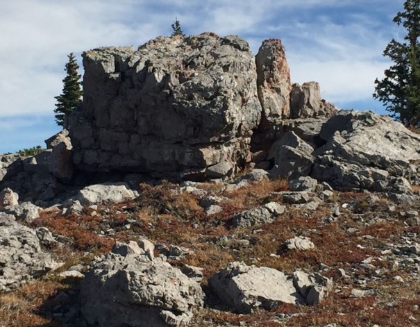
Turtle Rock! From here, turn left (north) towards the main summit cairn. We had lunch behind this rock as a wind block. From here, you can head straight down the scree slope and you will intersect with the main trail.

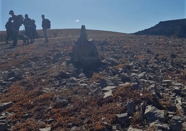
From Turtle Rock, we continued north along the wide ridge to the giant cairn that marks the end of the mountain. You can see this cairn from the parking lot, and I love pointing it out to people in advance. The ridge has been very windy both times I was up here, so after a few quick pictures, we turned around. For lunch, we hiked back to Turtle Rock, and down the east side of the ridge for as much wind protection as possible.
If you take the cut off, the trail is a very convenient 3 KM from the Y junction at the base of the climb, and about 600 m (1,987′) total elevation gain. It’s an additional 600 m or so if you take the more gentle approach.
Forget Me Not Ridge – South
For my second hike, I knew to keep straight on the scree slope and take the gentle approach up to the ridge. At the cairn near the top, we turned right (or more accurately, continued in a southerly direction). This was about 5.4 KM, and 576 m (1,900′) of elevation.
Hiking across the ridge is an amazing landscape that can best be described as the Scottish Highlands. I’ve never been, but Gillean Daffern describes it in her Guide Book as reminding her of home. For this stretch, we spread out and enjoyed each other’s company, as we made our way towards the high point of Forget Me Not Ridge.

We have already crossed the flat ridge, descended down a short slope, and are now making our way up towards the South Ridge high point. The long grass and wide open spaces are simply gorgeous, and not a common sight in the Rockies.
At about the 7 KM mark, we start back up another slope (shown above), which leads to a most enjoyable sight. For me, there is nothing more fun than going up rock steps. It makes quick work of elevation, it breaks up the monotony of a five hour hike, and it can be a real thrill for new hikers.

This is us coming back down the rock steps.
From above the rock steps, the terrain changes again. We were treated to what can best be described as ‘rivers’ of boulders. These streams of rocks trickled across our path of thick grass, and we jumped across them as we would narrow creeks.

Little rivers of rocks crossed our grassy landscape.
Further on, we came across fields of sizable boulders that we slowly picked our way through. These boulders were covered in grippy lichen, which made the crossings very enjoyable.

One of the very grippy boulder fields. This is looking back at Forget Me Not Ridge – North (straight ahead). You can see the path from the screen slope across the ridge to this point.
 We even found an outcrop of rocks that we could not resist playing on. This hike really does have it all if you just want to take the time to fool around and enjoy the offerings.

Very close to the South summit of Forget Me Not Ridge.
After passing above the weather station, we angled left to nab the high point of Forget Me Not Ridge at the South. We had a very enjoyable lunch, mostly out of the wind, and contemplated life. It took us 3 hours, 8.2 km, and 696 m (2,297′) of elevation.

The summit cairn for Forget Me Not Ridge South. Downtown Calgary is easily seen from here.
After lunch, we looked across to the summit of Forget Me Not Mountain. According to Bob Spirko, the height of the mountain is actually lower than the South Ridge high point. As we didn’t feel the extra 6 km (return) was worth the time, we decided to go home.
We returned the way we came, and got to enjoy the scenery from a different point of view. As we descended through the elevation below the wide scree slope, I kept hearing people say they didn’t remember how steep the trail was, or had completely forgotten about different parts of the trail. Maybe there is something to the name of this mountain after all???

In late September the Little Elbow is quite low. When I was here in June, we watched some horses crossing. They were in pretty deep, and their dog was having a hard time getting across.
After we crossed the Elbow River dry creek bed, we headed over to the ford that crosses the Little Elbow River. I love a good cold river foot soak at the end of a hike. I thought it was ideal that I could cross the river, take off a km of walking, and cool my aching feet all at once.
Thanks for reading this trip report. If you’ve done Forget Me Not, then please share your experiences in the comment section. If you have any questions, please leave a comment so everyone can learn together.
Happy Trails!
Daily Totals – Tracked on Strava
Forget Me Not Ridge – North:
Distance – 11.9 km
Elevation – 602 m (1,987′)
Total Time – 5 hrs (Moving time 4 hrs 45 min)
Forget Me Not Ridge – South:
Distance 16.3 km
Elevation – 797 m (2,630′)
Total Time – 6 hrs 12 min (Moving 5 hrs 30 min)
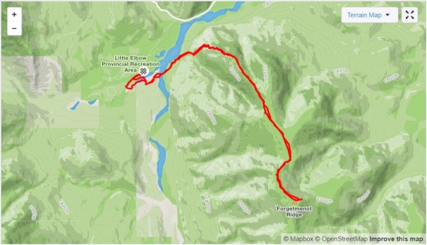
Our route to Forget Me Not Ridge South. By taking the river ford on the return, we cut off some distance.

As you can see, a lot of the elevation is gained as soon as you turn right at the Y junction. Due to the lovely trail and the changing scenery, it is very enjoyable.
I love all things mountains! I live next door to the Canadian Rocky Mountains, however I travel the world to enjoy the many different mountain environments and cultures that I can. I hope you enjoy these trip reports, and that it inspires you to accomplish your own adventure goals.

Leave a comment