August 23, 2017
July 21, 2019
Like Forget Me Not Ridge, there are very few hikes that I would do more than once, and Pocaterra Ridge is one of them. It is a great combination of gorgeous views, undulating terrain, a good distance, and a fun way to gain elevation. I first hiked Pocaterra on the recommendation of my hiking buddy Annette, who has a real nose for excellent ridge hikes. We brought along another couple, and my two 15 year old daughters (who stayed with us for a bit, before shooting ahead. I found them again at the parking lot.). I just recently redid this route as a guided hike for the Highwood Cycle Club, and this is my trip report.
The Pocaterra Ridge hike has three variations. One is to do a loop. You start at the north end, hike the ridge, and then descend into the valley to the right (west) of the the ridge. This is a very long day, and a return trip with zero views. Versions Two and Three are the same – but from different directions. Most people do the route starting in the south at Highwood Pass parking lot, and make their way north. I prefer to start at the north end at the Little Highwood parking lot, and make my way south.
Why north to south? It is not very busy this way. The parking lot is empty in comparison to Highwood. The trail is also less busy. The two times I’ve done this hike, I didn’t meet anyone on the trail until we were at least half way (first time) and then on the summit (second time).
It just might be quicker to go north to south. The first time I hiked Pocaterra, we meet a hiking group from Canmore at the 1/2 way mark. We ended up at the north parking lot at the same time, so we compared our numbers. Not that it was a competition, but we did our version a good 30 minutes faster. Of course, this depends upon group size and hiker fitness, but I feel that a hiking club from Canmore should put in a good show.
One last reason to go north to south is for transportation reasons. If you do not have two cars, ending at Highwood Pass means you have some options. You can leave a bike chained up here, and pedal back down to your car. It is a super fun, steep downhill ride back to your car. Speed demons only may apply. Or, you can hitch a ride north back to your car. By the time you finish, especially on a weekend, there will be about a million people leaving Highwood to go back to Calgary. Be nice, and someone will take you.
So, now that I’ve convinced you to start at the north end, let’s begin!
Trail Head
After you’ve stashed a car or bike at Highwood Pass Parking lot, make your way north on Highway 40 to the Little Highwood Pass parking lot. Cross the highway, and look for a small opening in the bush. Like all hikes, finding the trail head is always the hardest.
Go through the thick forest, following a meandering trail, until you come to the first of two water crossings. Depending on the time of year, the water is either low and can be easily walked across, or it’s higher and you’ll need to cross on a log, or take your shoes off.

Theo crossing the creek at the start of the hike. 2019 was a wet year, and it had rained pretty hard right before our hike. We had great weather, but the creeks were pretty high for late July.
Once past the second water crossing (might be dry) at around .7 km, look for the trail veering off to the left. You will begin to climb almost immediately. While the trail is pretty darn steep, it is also a gorgeous forest so enjoy the hike with no sun blazing down on you. You gain about 452 m (1,495′) in only 1.5 km.
Fairly quickly, the forest ends, and you emerge onto the first of many open ridges.

As you emerge from the trees, you are greeted with this beautiful sight, the first of four hummocks that make up Pocaterra Ridge.
From here, you can get a great view of Mt. Roberta to your right. This is on my hit list, but the bushwhack involved has kept me away. The photo below is looking back at the top of the first hummock, which is about 2.5 kms and around 2,357 m from the start.

Mount Roberta is the peak on the left (looking back the way we came), which is the final outcrop of Mount Pocaterra, which dominates your view to the west. Directly behind is Gap Mountain , I think!. If you know for sure, please leave a note in the Comments below.
The trail is now very straight-forward. Literally just walk straight across the top of the ridge until you hit the summit. What makes this hike so enjoyable though, are the undulations along the way. There are four major humps on the ridge, the final one being the highest and the summit. As you can see in the photo below, we are the only ones on the ridge on a busy Sunday in July.
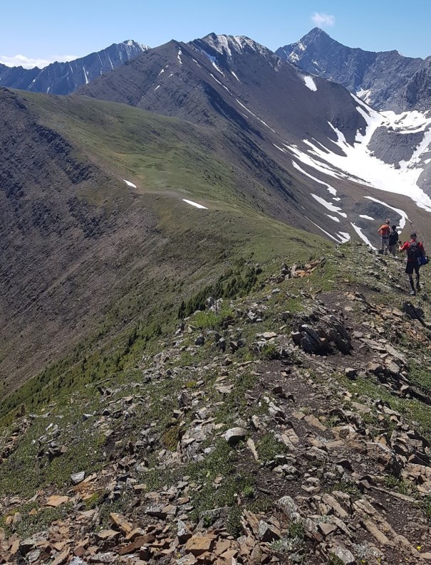
Looking towards the summit of Pocaterra Ridge. I love the four undulating humps.
Along the way, you will go in and out of forests on the west side of the ridge, while the east side is drier and has very little vegetation.
There is also no shortage of interesting rock outcroppings. Some of the lower ones can be avoided (but why?). Higher up, there are spots with giant rock steps to hike up. I love these, because it adds a new dimension to an otherwise straightforward hike, and it can be a real thrill for new hikers. It can also scare the pants off some people, like it did to David on my first trip up here.

Just one of many interesting rock outcrops to keep this hike interesting.
We hit the top of the second hump at about the 5 km mark, and around 2,557 m. Somewhere between the second and third hump are great spots to eat your lunch. If the wind is up, then just head down one side or the other a ways until you are in a wind shadow.
The first major view is of Elbow Lake, nestled between the massive peaks of Elpoca Mountain and Mount Rae.

Looking down at Elbow Lake. Most people have been there, so it’s a real treat to look down at.
The views on the trail are outstanding! You are sandwiched between two extensive ranges – Mount Pocaterra to the west, and the massive wall of Mount Rae to the east.
The first time I did Pocaterra Ridge, my twin daughters came with us. I had just scrambled Mt. Rae the week prior, and I was telling tales of my daring-do on the mountain. As my kids had already heard most of these stories, I had to endure sarcasm-dripping comments such as “No way! I didn’t know you climbed Mt Rae??!!??”I thought I was being entertaining, but I guess not.

Sizzle the Dog points to something squeaky, completely oblivious to the impressive spectacle of Mount Rae behind her.
We hit the top of the third hump at around 6 km, and an elevation of 2,535 m. This hump is lower than the second the fourth humps, so you lose some elevation here.
I saw that the third hump is being cut off by people coming from the south and heading north. When heading south, you can’t see the cut off until you are about to climb up the fourth hump. Don’t feel bad when you see this. For me, the reason I hike is to get the elevation and the distance. There is just no accounting for taste…
The final push up the forth and highest hump is the most fun. There are several large rock steps to climb up, and there is a bit of trail finding to do.
By this time, depending on when you started, you may see the flood of south-to-north people coming down towards you. The downhill hiker has the right of way, so be prepared to let them pass. Most people heading up don’t mind a bit of a break though. Please be aware of people directly above you, and watch for falling stones. It’s not likely on this trail, but possible.

Two members of the Highwood Cycle Club, Ross and Sonya (who leads the women’s group). The summit (4th hump) is behind them. If you zoom in, you can see hikers coming down. This is the first time we saw people other than our group.
The summit of Pocaterra Ridge really feels like you’ve done something. There is a great rocky outcrop, which is always a fun place for a group photo. The summit is around the 7 km mark, and at 2,633 m (8,689′) elevation. It’s nice that the last three humps are all exactly 1 km apart.

The HCC on the summit of Pocaterra. This was a first hike for many of them, but as they are all really athletic, I had zero worries.
The views here cannot be ignored. Looking south and west from the ridge, you get an excellent view of Mt. Tyrwhitt. The giant hole is easily seen, and there were lots of questions on how to get up there. Unlike my kids, the Highwood Cycle Club members were suitably impressed with my bagging this mountain.

Grizzly Ridge is to the left, and Mt. Tyrwhitt on the right. The pass between them is a lovely hike. From the Pocaterra summit, you can see the steep descent that leads directly to the moraine below.
Directly south is Grizzly Ridge, not to be confused with Grizzly Peak further down the road. You access Grizzly and Tyrwhitt from the same pass. The trail up to the pass is absolutely fabulous, as it winds through a moraine, and then gently climbs the scree slope. This is another popular hike for this area, but having done Trywhit first, I have yet to feel the need to go up Grizzly. If you go, please let me know how it was in the comments.
In the photo above, you can see the direct descent to the valley below. This is another reason to go north to south. Going from the south is just a long slog up a boring slope. I like to enjoy the route, even if it is slightly more elevation gain.
Depending on the day you go will determine how busy it is from here. The first time was mid-week, so it wasn’t too busy coming down. The second time was a Sunday, and it was BUSY! There were about a million people heading up the trail to the summit. Granted, most of these people were not doing the traverse, but it was still a bit of a shock after hours by ourselves.
The trip through the valley below is always a pleasure. I love coming down, and crossing the creeks with the stone steps. I love crossing the scree slope, and making my way through the changing landscape.

My daughter Kayla and hubby Mike well below the summit. This is below the moraine, and making our way across to the large screen slope in the cirque.
I love this trail right up UNTIL I hit the forest. There is a fork as you enter, and you need to take the upper (or right) fork. The forest trail gives you some unexpected elevation gain, which is a bit of a kick in the teeth if you’re tired. It is also incredibly muddy in parts. I seem to always hit this trail after a major rain event, and the muddy sections are just getting bigger and wider.
Finally, you emerge onto the final meadow that takes you back to the Highwood Pass parking lot.
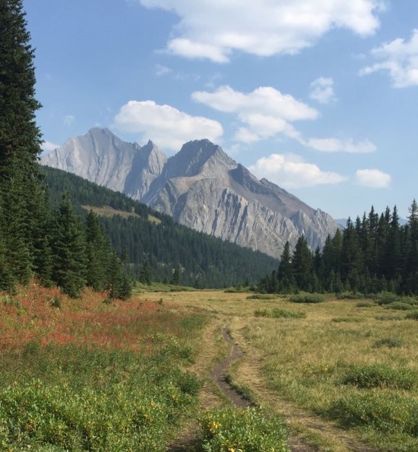
The final meadow before the parking lot. Mount Arethusa is putting on a fine show in the background.
Daily Totals – Tracked on Strava
Distance – 13 km
Elevation – 729 m (2,405′) from low to high.
Total Elevation Gain – 993 m (3,277′)
Total Time – 5 hrs 30 min

The map shows how Pocaterra Ridge is nestled in with all these massive ranges. Spectacular and close views on an easy hike.

The elevation profile shows all four humps, plus the little kick in the pants elevation in the forest when you are just about finished your hike.
I love all things mountains! I live next door to the Canadian Rocky Mountains, however I travel the world to enjoy the many different mountain environments and cultures that I can. I hope you enjoy these trip reports, and that it inspires you to accomplish your own adventure goals.

What an amazing hike this is!
Yes it is! Totally worthy to do several times to enjoy it over and over.
I am excited to try this out in a few weeks!
Yes, I hear the snow is finally retreating. There is a bear closure at Ptarmigan Cirque so that is pushing everyone over to Pocaterra. I’d recommend my route and starting very early to avoid the masses and having a better day.
Great info, It’s been on my list. Thanks
I’m glad you liked it. It’s a great hike. I don’t often repeat hikes, but that one I’ve gladly done multiple times. If you go, please let me know how you liked it.