July 11, 2019
I debated whether the south peak of Opal Ridge should be classified as a hike or a scramble. The majority of this trip is indeed a hike, but there is a mid-section of steep slabs with some cliffy bits that require route finding, plus a bit of hands-on-rock action. I never want to undersell a route (and have someone get into trouble) nor oversell it (and scare someone off). Two other Opal South trip reports were done by Bob Spirko and Explor8ion. As these two sites focus mainly on scrambles, I will say that Opal Ridge South is on the high upper end of hiking, and the lower end of scrambling. There. Done.
My hiking partner Annette and I really liked this route. It has a nice little warm up approach, and then gets right on it! After the initial vertical, you can tackle the exposed rock slabs. If you’re still game after that, then you are in for a real treat. It’s above the rock band that the trail get interesting and beautiful as you pass through The Gates on your way to the summit.
Trail Head
The trail starts at the far north end of the Fortress Junction Service station. There are no outhouses here, and the gas station had a large sign saying their washrooms were out of order. I imagine the owners are just tired of being the hikers’ dumping ground. If you need to use the facilities, stop at a trail head prior to Fortress Junction.
The trail starts straight up beside a little creek for about 200 m, and then goes left at the cut line. Follow this wide path for about 400 m, and then take the trail cutting right into the forest. It is marked by a cairn.
Lower Steep Stuff
The most common complaint about Opal Ridge South is how steep it is. Yes, it is steep, and immediately so, but not worse than other scrambles. Rather, it’s a big step up for someone only used to hiking trails.
On our day, Annette and I started out in miserable weather – cold, wet and windy. This was a wet summer, but as we had already committed to drive out, we thought we may as well make the effort. Going up this steep section we stopped a few times under the trees to avoid the worst of the showers. We discussed what our weather cut off would be. I was worried about a full-on electrical storm, or having the steep trail become treacherous with a downpour.
About half way up the steep forested section, our suffering was rewarded when the most beautiful rainbow appeared below us. I took this as a sign of good things to come, and we continued on in better spirits.

The end of the rainbow is on the Fortress Bridge. Maybe the Pot of Gold will include the ski hill reopening soon?
This steep section – while mainly a grunt – is still fun because there are little plateaus that hide the next big steep bit, which I think is great for keeping up the motivation.

The trail above the forest, and below the rock bands.
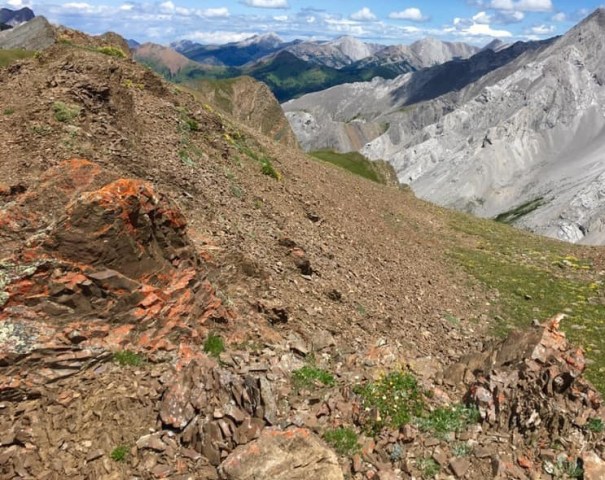
Scree and Rock Wall
This is the hardest part of the trail, and is a true scramble. After you emerge from the forest, the rock wall is above. There is quite a bit of scree to cross, but the trail is in good shape and easy to follow.
I read that Bob Spirko took one route up the slabs, only to take a completely different route down. I was trying to avoid this by taking mental and real photos of where I came up. There are some steep drop offs, and I didn’t want to get stuck on one during the descent. I too ended up taking a completely different route back down. I went up climbers left (following Spirko’s route), and came down skiers left.
At about 1.6 km and 1,952 m, we hit the first section of the slab rock. This was good fun, with a tall wall on our left for grip, and a pretty good trail.

Annette tackles the first section of the rock wall. A good trail takes you up the side of these slabs.
After this, things get trickier with multiple routes through the screen, none being any better than the next. We went up a nice crack that I was hoping to find again on the way down. Oh well. I will say that I stayed pretty much on route for the ascent when I compared my tracks to the map.

At the top of a narrow gully we just climbed up. There are multiple ways up, but some are better than others. Good route finding both ways is essential. One added benefit – we could keep an eye on Annette’s new car in the parking lot below almost the entire way.
There is no shortage of steep walls to scramble up, again with multiple choices of routes. Some of the cairns, like the one below, were more for decoration.

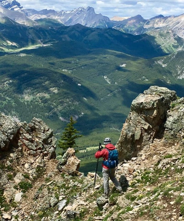
The rock wall, with the Opal Ridge South summit in the background.
The Gates
At about 2 km and 2,152 m, we got above the rock wall and could really start to enjoy this mountain. We were greeted by gorgeous meadows and an abundance of wildflowers. These meadows meandered nicely, and we found a little sheltered dip to have a snack before we climbed up towards The Gates.

Alisen in the meadow below The Gates. Just look at those gorgeous wild flowers! You know it’s cold when I’m wearing my gore-tex on the ascent.
I was a bit intimidated reading about going through the gates, but it was very straight-forward, and the scenery was stunning.

Annette moving through The Gates. It’s steep here, but the scenery is so impressive I didn’t really care.
The Gates themselves are stunning to look at, and there is an absolutely perfect photo stop along the way. This is about 2.4 km and at 2,232 m.
It is such a treat to hike with Annette. Not only is she an accomplished photographer, but she manages to capture brilliant photos without me noticing until we swap pics at the end of the day.
From The Gates, you cross the grass and scree slope heading towards the summit. There is a small scree bowl to go up. There are a few different trails here, depending on how steep you want to climb.
Once on top of the scree bowl, you are on the summit ridge. Now it is just a matter of hiking across the ridge to the base of the summit on the left. This area was incredibly windy, and I felt like I could be blown over. Toques and mitts were used.

The summit ridge is now very straight-forward. The terrain has changed again from below, which makes it interesting. You also start to get some new views.
Opal Ridge – South Summit
The hike up to the summit is very enjoyable. You are behind the mountain and out of the wind. The rocks are gorgeous with ever changing colours. The trail up through the rocks and scree is in fantastic shape.
The ever changing rocks makes this trip up the mountain very enjoyable.
All of a sudden, or so it seemed, we popped out on top and had views up and down the valley. The summit elevation was clocked at ~2,568, with a distance of 4 km, and 3 hours.

A look down towards Highway 40 and the Kananaskis Lakes. There is a little summit shelter made from the rocks. I just LOVE it when people take the time to do this. Thank you!

Looking just left of the photo above is Grizzly Col. Grizzly Peak is on the right, and Mount Evan Thomas is on the left.

Looking north from the summit. You can see our route up, across the ridge and down through The Gates. Beyond this is the summit of Opal Ridge North, which I did with my daughters on Mother’s Day a few years ago.
Return Trip
The way down is a reverse of the way up. Annette and I only met two other people on this cold and miserable weekday. We met a guy and his black lab making their way down the rock wall as we went up, and a female hiker who had just gained the summit ridge when we were coming down. Including the girl dog, it was kinda nice to know that 4 of the 5 beings on Opal South that day were female.
As I mentioned before, I somehow managed to go a different route on the descent through the rock slabs. I went way skiers left, but I was not disappointed. It was a bit gentler than what I took up, which made for easy down-climbing and saved my knees a bit. I did have to keep my eye out for the cairn that marked the proper descent after the rocks, but that was easily found.
As we trudged back to the parking lot, we realized an added benefit of Opal Ridge South. The trail ends at a lovely little stream, which we took advantage of. We quickly took off our boots, grabbed a snack, and soaked our feet in the cool water.
Thanks for joining me on this trip up to Opal Ridge South. If you have any questions, please leave a comment.
Happy Trails!
Route Totals – Tracked on Strava
Distance – 8 km
Elevation – 990 m (3,267′)
Time – 5 hrs, 20 min
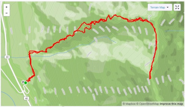
You can see my wayward track down through the rock wall.
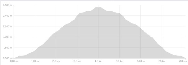
A nice elevation profile. An easy warm up, followed by steady elevation gain. The only relief is the summit ridge, which is so blustery it’s had to enjoy.
I love all things mountains! I live next door to the Canadian Rocky Mountains, however I travel the world to enjoy the many different mountain environments and cultures that I can. I hope you enjoy these trip reports, and that it inspires you to accomplish your own adventure goals.

Leave a comment