August 15, 2019
My hiking partner Annette and I were looking for a new hike. We are on a kick to hike or scramble as many new routes as possible, which means every week requires some research. To find something I haven’t done, I often troll satellite images and online maps to find the mountains that have escaped my notice.
Arethusa was one of those routes, but it had only escaped me in the summer. Arethusa Cirque is right next to Highwood Pass, which is a whopping 2,206 m (7,283′). Every year, we get hit with an early snowstorm and my family and I head up to Arethusa Cirque to get some ski turns in before Highway 40 is shut down for the season. Considering the amount of times I’ve skied here, it’s strange that I never thought to hike it in the summer.
Arethusa Cirque is only a few kilometres with mild elevation gain. To extend the trip, I’d need to add in a peak. I briefly considered Mount Arethusa, but it’s a full-on committed scramble for people with a lot of climbing experience. Instead, we decided on the completely doable Little Arethusa peak, which is an outcrop of the main mountain. It looks out over Highway 40, the Highwood Pass and Pocaterra.
This trip report covers both the Arethusa Cirque hiking route, and the additional trip up Little Arethusa peak.
Overview
Arethusa Cirque is a tight semi-circle surrounded by the impressive Arethusa (to the north) and Storm (to the south) mountains. You can do the cirque in either direction, but I prefer to go counter-clockwise as the uphill is more enjoyable with better views. You hike up to a wide plateau, traverse across to the other side, and come back down to the original trail.
Little Arethusa Peak is gained by continuing the traverse until you hit the base of the mountain. From here, you turn uphill and slog away until you reach the top.

Thanks to Google Maps, I was reminded of Arethusa Cirque. There are some nice peaks in this area, but only Little Arethusa was doable for our group.
Trail Head
Arethusa Cirque is located about a km south of the Highwood Pass Day Use area. It is on the east side of Highway 40, and is nothing more than a wide flat area. There are double track marks where cars have driven in, and I drove all the way up to the trail head. Ensure the ground is nice and dry before you attempt.
We easily found the trail head on the right, which is an opening in the forest. The trail starts climbing almost immediately.
Arethusa Cirque
As we got closer to the open cirque, the trail eased off a bit, but it also started to braid. I remembered the general trail from skiing here, but I followed the flagging to stay on the main trail. This is a fragile environment, and trail braiding is easily avoidable if everyone follows basic hiking etiquette.
Once we popped out of the trees, we got our first view of the Arethusa Cirque, and the impressive mountains towering above it. There is a lovely little stream down the middle, and it’s this spot where you chose which direction you want to take. We continued to the right to complete the cirque going counter-clockwise.

This is the beginning of the Arethusa Cirque, once you emerge from the trees. This is the creek where you decide to go left or right. We went to the right – counter-clockwise. On the way back, you have to cross this stream to regain the trail.
The trail followed the stream for some while, which provided lots of photography spots. We did have to cross the stream a few times, but there were little rock stepping stones to keep our feet dry.

We really enjoyed this stream on the way up. Lots of little crossings, and great spots for photos.
We continued to slowly gain elevation as we made our way to the right, contouring below Storm Mountain on our right. We were headed for the wide bench above us.
The terrain slowly changed from lush greenery to scree and boulders to hop across. At about 1.5 km from the trail head, we had to say good-bye to the stream as we turned left to continue gaining the ridge, which would give us even more views.
My daughters up ahead. The bench is the wide green area to the left. The uphill is very gradual with amazing scenery to gawk at.
Once we made our way up to the wide flat bench, we traversed across it heading north, taking in the views. Due to the high elevation, this is larch country. This place will be crawling with people come September, but it was nice and quiet on our August trip.

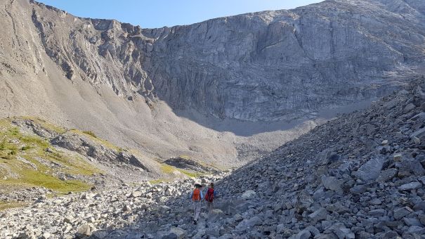
This is looking back down onto the bench. As you can see, there are a variety of gullies to follow downhill. Find the cairn to make life easy. Annette is crossing the scree field below Little Arethusa peak.
End of Arethusa Cirque to Trail Head
At about the 3 km mark, we found the cairn that marks the descent back down the ridge. I highly recommend finding this cairn, as the alternate routes might be climber’s short cuts, and could peter out into bushwhack. From the cairn, it is a very straight-forward descent, that basically goes straight down to the original trail below. It’s a bit of a slog in the trees with no views, which is why I like to go up the other way. This makes for a very quick descent through the boring bits.
A very straight-forward descent, mainly in trees, after finding the cairn.
At the bottom of the hill in the photo above, we met four older gentlemen in denim jeans, Tilly hats and massive cameras. They were debating continuing up the hill. Since they were three quarters of the way, we encouraged them on. Turns out, this foursome included two guys over 80! They were from Edmonton and had left at 5:00 am in order to do this hike. I said they absolutely must keep going, because who knows when they will ever get back here. This was not a concern – they had already planned a return trip in the fall to capture the larches in full colour.
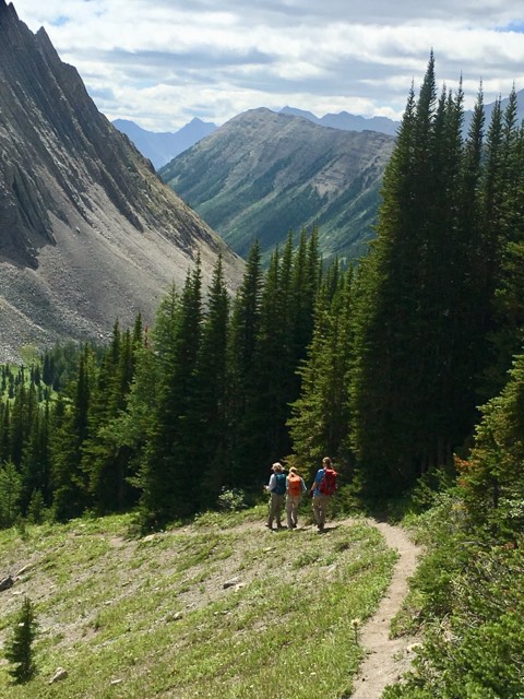
We continued on the trail through the forest, and magically arrived at the original spot where we decided to go counter-clockwise. Trying to find the right place to cross the creek took a bit of wandering up and down the trail, but I eventually found a low narrow point to jump across.
From here, we simply walked back down the trail to our car.
Little Arethusa Peak
To hike up Little Arethusa Peak, we continued past the cairn heading back to the trail head. We basically just continued the traverse across the wide bench under Mount Arethusa. As we crossed a large boulder field, my daughters went high, while Annette and I went low. It was a draw – it’s best to just keep the progress more or less level, as it’s a ways before the real uphill climbing begins.
The trail from the turn-off cairn to the summit of Little Arethusa is only about 1.5 km. What it lacks in distance, is made up for in sharp elevation gain. There was no trail leading to the base of Little Arethusa, so I didn’t expect to find one heading up. I looked up to what I thought was the summit, and started churning up the scree. We eventually found little rivers of trails through the scree that helped with the slog.

Annette slogging up the scree slope. The peak doesn’t look like much effort from the bottom, but this photo shows how much the mountain lays back, hiding the top from view.
Little Arethusa peak lays back, so it’s impossible to see the summit from below. When we hit what I thought was the top, it was instead just the first of a series of undulating ridge lines on the way to the summit. I was not disappointed though, as a nice trail lead from one ridgetop to the next, with bits of route finding and interesting rocks to look at. Very enjoyable!
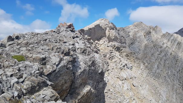
The ridge line to the summit of Little Arethusa peak. We worked our way along this, slowly gaining elevation and enjoying the views.
The views from up here are amazing. Storm Mountain to the south was particularly gorgeous.

This is heading back down, with Storm Mountain dominating the view. Access up this mountain is from the other side.
We finally hit the summit, and then backtracked to a nice protected area to have lunch. The wind was coming up and over the top of the mountain, and we got very cold, very quickly. It took us a very leisurely 2.5 hours and 4.4 km to reach the summit of Little Arethusa Peak from the highway, including the trip around the cirque.
For the way down, I followed the ridge trail, which lead us to a really excellent trail down the mountain. If you hike Little Arethusa, be sure to continue to traverse across the base of the mountain further until you hit this main trail. There were a couple of very large cairns so you can’t miss it, like I did.
From the base of the mountain, go back the way you came until you hit the cairn marking the descent, as described above. Do not try and go straight down from Little Arethusa.
I hope you enjoyed this trip report for both Arethusa Cirque and Little Arethusa Peak. If you do this route, please tell me about it in the comments. If you have a question, please also leave a comment so everyone can learn.
Happy trails!
Totals – Tracked on Strava
Arethusa Cirque Only:
Distance: ~4.2 km for the loop
Elevation: 266 m (877′)
Time: Approx 1.5 to 2.5 hours
Little Arethusa Summit & Cirque:
Distance: 7.3 km
Elevation: 590 m (1,947′)
Total Time: 4 hours
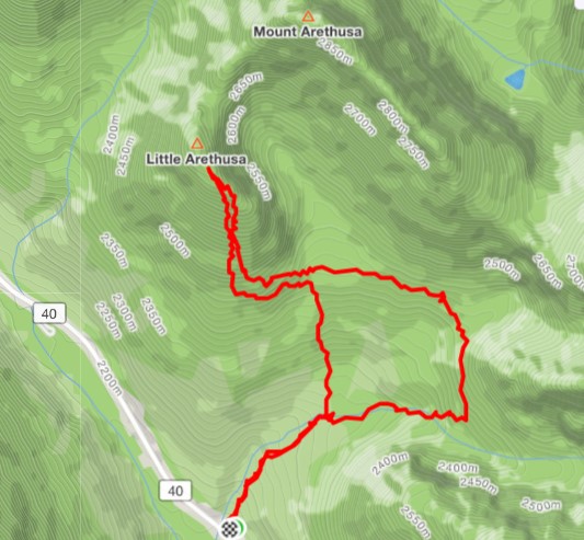
You can see my return route off Little Arethusa Peak is to the west of my ascent. This is a great trail, and is marked with a few giant cairns.

Other than the trip up to the peak, this is a very easy hike with minimal elevation. If Highwood Pass is packed, consider driving down the highway to Arethusa for great views and interesting terrain.
I love all things mountains! I live next door to the Canadian Rocky Mountains, however I travel the world to enjoy the many different mountain environments and cultures that I can. I hope you enjoy these trip reports, and that it inspires you to accomplish your own adventure goals.

Great post 😁
Thank you! It’s a great little adventure.
No problem 🙂 check out my blog when you get the chance 😄
The Canadian Rockies look awesome! Great posts! — YUR
Thank you! I am having a 25+ love affair with the Rockies. I am not sure I will ever get enough of them.