This is Day 3 of the Bonnington Traverse. Click if you missed Day One (Bombi Summit to Grassy Hut) and Day Two (Grassy Hut to Steed Hut).
March 7, 2020
After a great night’s sleep and a warm hut, we awoke at 6:00 am ready to take on the day. The snow had kept up all night, and would continue all day as well. We knew the avalanche conditions were Considerable at alpine, and tree line. The extra loading from this storm system just might be the trigger to release the slab layer that had formed. We needed to pick conservative routes up and down.
Overview
From the Steed Hut, we skied down the ridge to our left. From the low spot of crossing Rush Creek, we made our way up to the col. From here we turned right and skinned up a series of small peaks, marked by poles. At the last peak, we took off our skins and had a glorious ski down to the valley bottom. At Erie Creek, we turned left and made our way up the long ascent to Copper Hut.
There are precious few photos of this portion of the traverse for two reasons. One, the snow was really coming down. Great big flakes were making everything wet. Mike had his phone out several times for navigation and could barely make it work because the screen was so wet. Taking photos in these conditions is not ideal. Two, the photos would all look the same. Once we got off the ridge, we spent the rest of the day in the trees. With no views, one shot of trees would look like all the rest.

Our ‘views’ for the next two days. A storm has set in, and we have lost all visibility. We can see features immediately in front of us, but can’t do any long range visual planning. Good thing for GPS and an excellent set of tracks.
From Steed Hut to Copper Hut
We awoke early and managed to get right on the packing. We were out the door in record time, which is saying something when you are travelling with Callum. I’m used to being the slowest, but he makes me look amazing.
Below is a close up of the first part of today’s traverse. From the hut, we traverse left and down. After crossing Rush Creek, we skied up to the col. From the col, we traverse the right on the right.

Our trip from Steed Hut to the final peak on the ridge above the col.
From the hut, we turned left and skied down the right side of the ridge to the low point. With the fresh snow, excellent turns were found and enjoyed.

Looking back at one of the slopes we skied down from the hut.
From the low point, we continued to traverse across Siwash Mountain. We were headed towards the low point to cross Rush Creek. This would be the first of two creek crossings today.

This is our traverse over to Rush Creek, the first of two crossings on today’s traverse. Our destination is ahead, but sadly no views.
We kept high on the traverse and tried not to lose too much elevation because we had to ascend the slope across from Rush Creek.
There were a lot of snowmobile tracks here. We could see where they were high-pointing on the various slopes to our left. As it was now Saturday and the snow was coming down hard, I was positive we would start seeing sledders at any moment, but no. We had the Bonnington to ourselves for the fourth straight day.
After we crossed Rush Creek, we started up the slope to the col. With the snow loading and the two week layers forming a touchy slab, we were careful to use the trees on our right to ascend the slope. We could see some old ski tracks crisscrossing the fan of the slope. I can only imagine they were made during more stable conditions.

Callum nearing the top of the col. It narrows quite a bit at the very top. Sorry about the photo quality. I whipped out my phone and took a quick shot before it got too wet, and this was the result.
It was very windy at the col, so we went over to the other side for a short break. We had been skiing for just under 2 hours at this point, and a snack was in order.

At the col, but on the far side to get out of the wind.
From the col, we headed right to gain the ridge. Despite how narrow the col was, the ridge was suspiciously wide. It actually looked like a logging road that had been cleared by a snow plow. It was a surprisingly low grade switchback up to the ridge.

This photo doesn’t do the trail justice, but you get the idea. A wide, low angle road that hugged the side of the ridge and made for a really enjoyable ascent up to the ridge above.
Once we gained the ridge, there were a series of undulations as we made our way to the far end of the ridge.

Mike and Brian on the first of the small ‘peaks’ on the ridge. Each one is marked with a black post. Again, stay well back from the left edge as it is another cornice-infested drop-off.
Skiing the ridge with low visibility and no definition was tough. Mike went first, and was our Crash Test Dummy. He found all the unexpected dips and walls that were near invisible in this weather.

A great view of the undulating ridge line. Watch for cornices on the left. Mike is approaching the second small ‘peak’ on the ridge, marked by another black pole.
There was one tricky spot on the ridge. It’s a bit hard to tell from the photo, but the ridge got quite steep and narrow. There is a big cornice on the left, and the right side has a series of steep gullies. Callum stayed back up high and shouted to Mike how far left he could go. Mike tried to go further right (below the far trees on the ridge) but the snow on one of the gullies gave way and he slid down a ways.

Mike put up a tight line on the ridge as it got steeper. He hugged the trees on the right to avoid the left cornice.
The end of the ridge is marked by double black poles. From here, we skied down to the left, staying left of the ridge.

The double black poles mark the end of the ridge. From here, we skied down to the left.
Below is a close up of the map for the rest of the trip. From the far right side of the ridge, we skied down to the left and around the base of the ridge. Once we crossed Erie Creek, we started up the slope of Copper Mountain. You can see where we turned left to find Copper Hut.

A close-up map of the traverse from ridge to Copper Hut.
Once at the low point, we angled right around the base of the ridge, and headed for Erie Creek. This was our second of two creek crossings today. The trip down to the creek was pretty interesting. Again, Mike was our Crash Test Dummy as we followed the drainage. There were many dips and doodles as we poked our way down the sometimes narrow gully.
Luckily we were keeping a sharp eye on our GPS and elevation, because it was very easy to ski past the creek.
We stopped here and had lunch. We had been skiing for about four hours, and traveled about 8 km.
Once across the creek, we tackled the last slope of the day – the ascent of Copper Mountain! It was about a 500 m elevation gain, but the trail up was set by someone who loved a good switchback. I was thankful for that. There are no photos of this section because it is all trees with no views. Plus, the snow was really coming down, and we were starting to get soaked. It was best to just keep going and find the hut.
Copper Hut
The people who had come in prior to us MUST have been here before. When we got to the proper elevation that Copper Hut is marked at, there was no hut. We were actually quite a bit above the proper elevation, but again, no sign of the hut. Callum was out front and saw some tracks from the previous party. We followed them even further up Copper Mountain, until they made an abrupt left turn. This side slope then made a direct line for Copper Hut.

Our first view of Copper Hut as we traversed across the slope. Again, these huts take quite the snow load.

Check out how much snow is on Mike’s pack. We are all covered in a thick layer, and our gore-tex jackets are damp. The extra wood is stored underneath the deck. Please don’t be a dick – carry out your used propane bottles. We found someone’s old canister stuffed in with the wood.
I also loved Copper Hut, which was built by the KMC in 1985. It has it’s own special charm just from being out here in the middle of nowhere, plus it has some special features. The first is the Hobbit Door. Not only is the door really low, but there is a low wall to step over. This ensured that we all took turns bashing our heads as we went in and out.

The Hobbit Door. And no, Callum is not that tall.
Inside the hut was very cozy. It sleeps 6, but again we found four people were enough to fill the space AND all the pegs for hanging all our wet gear. This hut has a small table and a low bench in front of the fire.

Mike drying out in front of the fire. The bunks on the right are doubles, and the ones on the left are singles.
The kitchen came with two neat gadgets. The first was a stand to hold the propane bottle. The next was a flip out counter because the two-burner Coleman stove takes up the entire kitchen counter. Good thing we had a Civil Engineer along to figure out these helpful tools.

The propane canister holder, and flip-out counter. The left burner on the propane stove was broken.
Getting snow to melt for drinking water is a fun part of hut life. With the low Hobbit Door, we had to come up with a way to get in and out without causing a concussion. Always leave one foot outside!
The design of the hut meant that the roof was quite low on the sides. As Mike and I were sharing the top bunk, this meant I was tucked up against the wall. This was my view from bed. Those are my toes in my sleeping bag. If I woke up too fast, I would simply go ‘back to sleep’ in a hurry.

I had to remember to get up gently the next morning or else risk getting bonked in the head. I didn’t mind though – I had the warmest spot in the hut.
That evening the snow not only stopped, but we also had bright clear skies. We had amazing shots of Jupiter, and the moon was just about full. We had high hopes for clear skies the next morning, which would be essential for the knife-edge boot pack tomorrow morning.

We were very thankful to see clear skies in the early evening. We had quite a dump of snow today, and we are looking forward to good visibility tomorrow.
Thank you for joining me on the ski from Steed Hut over to Copper Hut on the Bonnington Traverse. To read the final day as we ski back to reality, click HERE.
If you found this post useful, please do me a huge favour and click the Star button to “Like” it. You can also follow my blog, or join my facebook page Al’s Adventurers.
Alisen
Totals – Downloadable Tracks on Gaia, Displayed on Strava
Date: March 7, 2020
Group: Four (Alisen, Mike, Brian and Callum)
Distance: 10.88 km
Elevation Gain: 790 m (2,607′)
Elevation Loss: 973 m (3,210′)
Time: 6 hours (includes lunch, snack and skin on / skin off transitions)
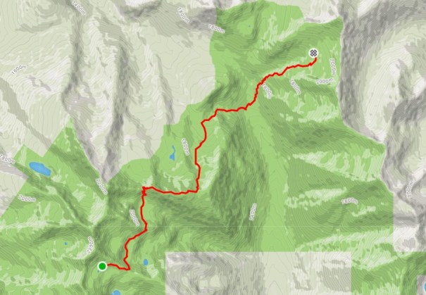
This is our route from the Steed Hut over to the Copper Hut. Again it was a day of ups and downs, but more sustained than yesterday. The two creek crossings made for a bit of a challenging trudge through the forest, but again, a very good day in the mountains.
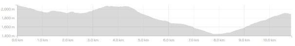
Our profile shows how much elevation we have to lose in order to gain it all back again on Copper Mountain.
I love all things mountains! I live next door to the Canadian Rocky Mountains, however I travel the world to enjoy the many different mountain environments and cultures that I can. I hope you enjoy these trip reports, and that it inspires you to accomplish your own adventure goals.

Leave a comment