March 8, 2020
We woke up Sunday morning to two major surprises.
We wanted to get an early start today because of the distance we had to travel, and the increasing avalanche danger. We needed to be off the touchy ridges and through a dangerous avalanche slope / trap before it warmed up too much. We were waking up at 6:00 am every morning with no problem, we thought we were good.
The first surprise was waking up at 7:00 am!!! At first I thought it was because Copper Hut only has two windows on either side, both of which are covered by overhanging snow. I thought we all slept in. Brian was texting with his girlfriend via InReach, and discovered that it was actually Daylight Savings Time. We had lost an hour.
The second major surprise was the snow started up again overnight. Callum was up for his usual midnight pee and fire stoke, and saw the snow coming down hard. He didn’t sleep much after that, worrying about the worsening avalanche conditions.
This meant we had to take a serious look at today’s route. It’s fun to bag your initial objective, but it’s better to all come home alive. Our initial route was to come out at the Porto Rico trail head, located between Nelson and Salmo. This is a long series of ridges, with one exposed boot pack section. It also has a dangerous avalanche slope near the end that the guide book says to avoid in high avalanche conditions or late in the day.
By 7:00 am at least another 10 cm of snow had fallen, with way more coming down. Add this to the conservative estimate of 20 cm the day before. We knew from the MIN reports in the area that ridges were avalanching from skier triggered events. There were two weak layers in the snow pack. The extra loading from the new snow, plus skier activation, made a high likelihood that this slab would start moving.

When we arrived at Copper Hut the night before, Callum didn’t immediately pick up his skis. About an hour later, they were all but buried in the fresh snow. The tail of his ski is in the lower left corner, and the binding is in the top middle of the photo.
The alternate route out is the Bonnington Dam, which is located on the other side between Castlegar and Nelson. This route requires a bit of back-tracking and a good 20+ km day, but the route was safer with more manageable avalanche terrain.
We spent the morning planning our new route on the maps. The Plan B route to Bonnington Dam is marked on the GPS tracks, but it starts from the Steed Hut. We would need to eventually pick up that trail, but we also wanted to maintain our elevation for as long as possible to avoid a long hike up later. Mike and Brian loaded the route into their GPS.
The last thing we needed to do was tell our shuttle driver Michelle that we were now exiting at Bonnington Dam. Michelle also has an InReach, and before we started Brian connected our devices. We sent Michelle a text with our new location and approximate time of arrival.
Overview
From Copper Hut, ski down the slope, and traverse skiers right keep elevation. Cross Erie Creek, and head for the flat area between Siwash Mountain and Mt. Connor. Traverse until you come to the main logging road that takes you to the SnowWater staff parking lot. From here, follow the road all the way down to Bonninton Dam.
From Copper Hut to Bonnington Dam
We skied back out from Copper Hut on the trail we took in. Once we were in a bit of a clearing, the fun began. We had an absolutely glorious fresh powder ski down this slope. If we didn’t have such a big day ahead of us, another lap would have been in order.

Brian and Mike near the bottom of the slope, making plans to turn right and start the traverse across to Erie Creek.
Now for the trudge. Mike set a line to skiers right to intersect with Erie Creek quite a bit higher than where we crossed the day before. During this section, there were some benches for more or less level travel, however, there were also lots of small gullies and sharp dips that slowed our progress.

This was one of the easier spots on the traverse. Lots of breaking trail in deep snow, but nicely spaced trees.

Trying to find a good way across Erie Creek was a bit of a challenge. From this spot, Mike (ahead and out of the photo) couldn’t find a good way ahead, so ended up turning around and going up the slope behind Brian.
We were not the only skiers to take this route. We could see faint tracks of skiers who had gone before us.
Once we got into the main clearing along the base of Mt. Connor, we tried to find Saddle Cabin, a snowmobile warming hut. From there, we thought we could pick up the snowmobile road down to the main SnowWater road.
Unfortunately, finding the hut without exact coordinates was not easy. We were in the general area, but there were snowmobile tracks heading every which way. With deep snow for breaking trail, we decided to instead head in the general direction of the road.

Mike and Callum discussing directions. As it turns out, at this point we were very close to Saddle Cabin. I would recommend punching in the exact coordinates of Saddle Cabin just in case you have to exit via Plan B. Check out how deep the snow is. Great fun for runs, but slow work when breaking trail.
I have to admit, that the tree spacing in the Bonnington’s is absolutely ideal for punching in a trail where ever we needed. As long as we stayed away from the gullies and creek beds, it was pretty nice traversing this low down.
After about 2 to 2.5 hours of skiing, we came to a clear cut area. From here, we picked up a logging road heading in the correct direction.

Leaving the forest and entering the clear cut area. From here, we continued over a little rise, and then turned left to pick up a logging road heading in the correct direction.
We were not on the logging trail long before we started to hear some motorized sounds. We thought there must be sledders around, but we couldn’t see anyone.
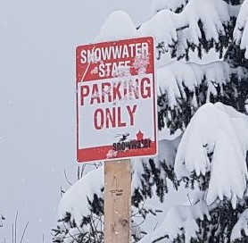
It came as a bit of surprise when we came around the corner to see trucks parked. This is the Snowwater Staff Parking lot. This meant we were on the right track.

Callum in the Snowwater parking lot. The cat track for the operations is directly behind him.
Our location suspicions were confirmed.
After following the road down about a km or so, we met the Snowwater cat picking up their guide and guests. We chatted for a bit, and made sure this road made it all the way back to Bonnington Dam. It does, so we set off for a long slow descent back to reality.

The Snowwater cat loading up their guide and guests for another run.
For the vast majority, skiing down this road was pretty enjoyable. Thankfully it had just been packed down by the cat, and had enough grade to keep us going downhill. There were also some fun spots where we could pick up speed. Some of Brian’s skin glue transferred onto the base of his skis, so he was gummed up pretty bad. This meant a very slow descent / shuffle for him. Mike scraped the bottom of his ski, using the edges of the other one, and that helped a bit.
I absolutely froze on this section. The trail is mainly in the shade. As we descended, we also entered a layer of low cloud / fog. About half way I had to stop and put on every piece of clothing I brought, including my down jacket. I even popped some Hot Shot warmers into my mitts.
We stopped for lunch at the 4 KM mark. This was just after a giant U-Turn as the road crossed a creek. The road to this point was in great shape. As we ate, we started to see people from town. We chatted with a sledder on his way up, and two trucks that used this as a turn-around point.

From here, we are only 4 km away from the main road. There are road KM markers in the trees.
After this, the road really deteriorated as the snow melted. We were losing elevation quickly and the day was heating up. The vehicles made a muddy mess.

I had my skis tuned prior to this trip. I am still not brave enough to look at the bases after this section. All I really know for sure is that Ray, our ski tuner, will give me a major lecture on how to care for my skis next time I drop them off…
When we got our first views of the canal, we knew we were very close.

Very close to the end now.
From here, the logging road makes a big U-Turn to the left to join the main paved road. Ski down the side of the road and cross the canal.

It’s time to take off our skis for the last time. We walked across the canal. On the far side of the bridge on the right is a parking lot. This is where we waited for our ride.
While waiting for Michelle to pick us up, Mike got a little bored. Breaking trail and navigating for 5 days wasn’t enough to tire him out.

At 50 years young, Mike is still a big kid. He was incredibly strong on this trip, as always. Not only did he break trail almost the entire way, but he also has the patience of a saint.
As always, we did a post-trip photo. It’s good to see we are all still smiling!

Mike, Brian, Alisen and Callum. We are stinky and filthy, but very happy. What an amazing trip!
Thank you for joining me on the four day adventure of the Bonnington Traverse. If you missed the prior days, you can click here for Day 1 (Bombi Summit to Grassy Hut), Day 2 (Grassy to Steed Hut) and Day 3 (Steed to Copper Hut).
If you found this post useful, please do me a huge favour and click the Star button to “Like” it. You can also follow my blog, or head on over to Facebook to join my page Al’s Adventurers.
Alisen
Totals – Downloadable Tracks on Gaia, Displayed on Strava
For Tracks from Copper Hut to Porto Rico exit, download Here.
Date: March 8, 2020
Group: Four (Alisen, Mike, Brian and Callum)
Distance: 22.4 km
Elevation Gain: 183 m (604′)
Elevation Loss: 1,618 m (5,330′)
Time: 6 hours 15 minutes (includes lunch)

Once we found the main road, our trip back was easy. Finding the road took a bit of work, but it was the safe thing to do with the increased avalanche danger.

So while it was over 20 km, the vast majority was downhill. There were some annoying uphill sections on the road, but we were able to get up those without skins.
I love all things mountains! I live next door to the Canadian Rocky Mountains, however I travel the world to enjoy the many different mountain environments and cultures that I can. I hope you enjoy these trip reports, and that it inspires you to accomplish your own adventure goals.

Great post 😁
Thanks. I hope you are inspired to get out into nature.
My Goodness..!! What a beauty.. 😍😍❄❄❄❄❄❄
With so much Ice all around you, what else is left to ask for?
I Love ICE and SNOW with Freezing temperatures – the colder, the better..
The Bonnington trail is so beautiful. You have perfectly described the details with mathematics, which is quite interesting (though I am not very good in solving maths problems in an instant)
I can see that you have had a wonderful skiing trip..!! Wish we had the winter season full of ice and snow for 365 or 366 days a year on every town or city of the world..!!
Thank you Madam for sharing.. ❄
You make me laugh! Yes, if you live in a country with a solid winter, it’s best to learn how to love snow and cold.
Aren’t Ice and Snow beautiful? We live in a country with minuscule amount of ice, snow or winters..
Thank you for sharing Madam..!! Your posts are so beautiful.. 😊