May 25, 2018
White Buddha Traverse is an ideal early season and beginning hike. It’s also great for young kids who don’t want to trek forever, yet still have some fun. What it lacks in distance or elevation, White Buddha more than makes up for it with spectacular limestone walls that accompany the hiker for a good portion of the trail.
With these tantalizing walls, it’s no surprise that this is a very popular sport climbing area. If you see climbers, please be respectful. Do not walk on their ropes, go underneath a climber, or between a climber and their belayer. Say hi, and ask them where they want you to walk.
Gear
As this is probably the lowest elevations you will find, the snow disappears fairly early. You can push the season a bit, but why? Regular hiking shoes and poles should suffice. If you do go in snow conditions, then dress accordingly.
Overview
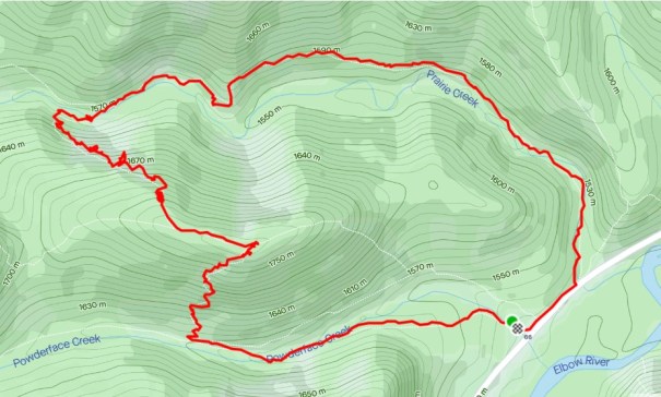
From the Powerderface Parking lot, head down the Powderface Creek trail. After about 1 km, turn right to ascend the White Buddha ridge. At the top, either return, or continue across the ridge and make your way back down to Prairie Creek. This will connect you with the Prairie Mountain traverse trail, which leads back to the highway.
Trail Head
From Highway 66, pull into the Powerderface Parking Lot, which is the last parking lot on the right before the winter gates. Note: If you are hiking Powerderface mountain, continue to the winter gates and park there.
From the parking lot, head west to start hiking alongside the Powerderface Creek. Stay on this trail for about 1.2 km.
Main Trail
After crossing a small bridge, keep your eyes peeled for the trail that heads north (right) and heads straight up White Buddha Ridge. This is pretty much the only elevation gain (there is a bit on the other side) for the entire hike, so enjoy it. The path is well beaten in, with just the right amount of switchbacks. It is a short 1 km from the turn off to the top.
While ascending, make sure you look back to see the summit of Powerderface North.

Hiking up the fairly steep trail. Looking back, the ridge across the valley is Powderface. In the distance, you can see the north summit with its telltale lingering snow.
After a short while (less than 1 km) you arrive at the white limestone walls of White Buddha Ridge.

White Buddha is the name of the sport climbing area. Young kids will love to explore the lower sections of the rocks.
Once you reach the rock face, turn right (south) and make your way along the base.

There is a very well worn trail along the base of the White Buddha wall.
There are often sport climbers here, so again, be mindful of their ropes and give them a wide berth.

My daughter Kayla is making her way up one of the sport climbing routes.
After traversing along the base of the wall, there is one more small bit of elevation through some well-packed scree.

I quite enjoyed this little path through the scree. The trail is in fantastic shape as it winds its way up.
Once at the top, you are rewarded with lovely views of the Elbow Valley below. Plus, a large flat boulder is conveniently placed to enjoy a snack.

The summit boulder. From here, you can return the way you came (on the right), or turn around, and go down the other side of the ridge heading north west (on the left).
Optional Traverse
If this is all your young hiker wants to do, then simply turn around and return to the trail head.
To do the loop, head west from the summit boulder along the right (north) side of the ridge, picking your way through the forest.
Take a moment to look around. Directly across the valley to the north is Prairie Mountain. If you look down, you can see the Prairie Creek trail as it makes its distinctive left hand turn. From this view, you can see the sheer cliff that requires this detour.
You will connect with the Prairie Creek trail to get back to the parking lot.

A unique view of the Prairie Creek trail that connects with the Prairie Mountain traverse trail.
As the trail descends, you will soon find yourself at another limestone wall. This is another very popular (and busy) sport climbing area.

Another wall of limestone. Keep this on your left as you descend. Stay with the wall until it ends to avoid cliffing out below.
Hike along the base of this limestone wall for a ways, enjoying how the rock changes as you go. It really is a unique rock outcrop. Stay with the rock wall until it ends.

This is just one of many photos I took. The wall keeps changing as you hike along. So gorgeous, and a unique feature.
Do not be tempted to head straight down to the creek below, as there is a major cliff band, not to mention an obscene amount of bushwhacking.

Looking back at the line of limestone walls along the summit ridge. Below is another sheer cliff that drops off into Prairie Creek. Do not be tempted to head straight down to the creek as you will cliff out on this lower wall.
Once the wall of limestone peters out, the trail leads directly down to Prairie Creek.

Viewing Prairie Creek from above on the White Buddha Traverse trail. Across the creek is the Prairie Creek trail. Go right after the creek crossing.
To cross, you can either ford the rocks if the water isn’t too high, or you can go downstream a little ways to cross on the suspended logs.
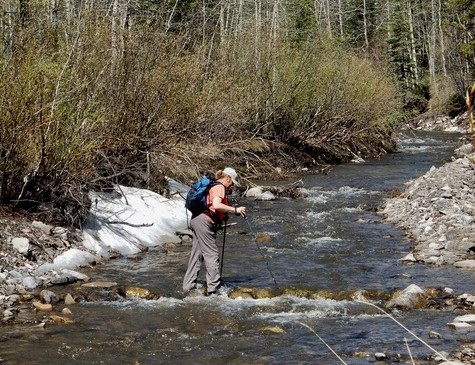
Sue fording the river using the rocks placed there. Photo credit: Annette Caesar.
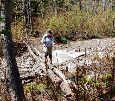
I’m crossing on the double logs placed a little ways downstream. Photo credit: Annette Caesar (although I told her not to take my photo, I’m now glad she did).
Once you cross Prairie Creek, hike up the short embankment. You will immediately find the well worn Prairie Creek Trail. Be sure to go RIGHT (south) here, or else you will find yourself climbing Prairie Mountain.
From here, follow the trail (and the many hikers) back to Highway 66. Once at the highway, turn right (west) to return the short distance to the Powderface parking lot.
If you found this post useful, please do me a huge favour and click the Star button to “Like” it. You can also follow my blog, or head on over to Facebook to join my page Al’s Adventurers.
Alisen
Totals – Tracked on Strava
Date: May 25, 2018
Group: Three (Alisen, Annette & Susan)
Distance: 6.68 km
Elevation: 311 m (1,026′)
Time: 3 hours 25 minutes (includes lunch and snack breaks)
The summit of White Buddha is very close, and only makes about 1/3 of the total distance.
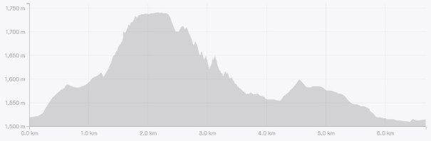
The vast majority of the elevation is gained just getting to the top of White Buddha, however, there are some descent elevation gains on the Prairie Creek trail heading back to the highway.
I love all things mountains! I live next door to the Canadian Rocky Mountains, however I travel the world to enjoy the many different mountain environments and cultures that I can. I hope you enjoy these trip reports, and that it inspires you to accomplish your own adventure goals.

Hello, Ma’am Alisen ( I’m giving to respect so I call Ma’am).
As you are giving the information about hiking. this’s useful for hiker.
Yes, I definitely hope it is useful for the hikers, both local and international tourists when we are all allowed to travel again.
[…] you follow the path to the west it will take you to the Prairie Creek Loop below Prairie Mountain ( read this blog) that takes you back to HWY […]
Thanks for linking to my blog. I’m glad you enjoyed this hike. It’s one of my favourites.