May 30, 2020
Heart Mountain is a classic Bow Valley scramble. It is also ridiculously easy to access, which means everyone and their dog go up it. However, as a guide friend of mine once said, “a lot of people underestimate Heart Mountain.” This is a scramble, not a hike. True, it’s on the easy end of things, but for pure hikers, this will be a step up.
The first time we took our kids up here, they were about 10 years old. It was pouring rain in the parking lot, which turned to snow the higher we got. By the time we arrived at the first scramble, we were soaked through. We had to make a hasty retreat, which wasn’t as easy as going up. Heart has an abundance of slick, flat rocks that are treacherous when wet or snow covered. As this was one of the few mountains my kids didn’t successfully finish, they asked to go back.
Gear
Quality hiking boots with proper grips. It’s best to not attempt this mountain in the winter or when it’s snowing. Heart is full of slab rocks that are deadly slick when wet or covered in snow. Also, you are on the edge of the ridge for most of the way. A young man died in 2019 when he got too close to the edge and fell off.
Overview
From the parking lot, head east on the trail. Once you cross the creek, head straight up Heart Mountain’s west ridge to the summit. To continue the traverse, stay on the undulating ridge until you hit Grant MacEwan Peak. From here, stay on the ridge as it curves back around, gaining two more mini-summits marked by large cairns. The trail quickly descends through scree, and then heads into the forest for the remainder of the elevation loss. Once off the mountain, head back to the parking lot.
Trail Head
From the Heart Mountain parking lot, start at the main trail and hike for about 1 km. Some people to prefer to park on the highway and cut out this section, however I find that a flat bit of warm up and cool down is great for the muscles. Your choice.

The start of the trail at the Heart Creek parking lot.
We started hiking at 7:30 am, which was a very respectable start considering we had two teenagers with us. As it was the weekend, we were expecting crowds and we ended up leap-frogging with a group that would rush ahead, and then stop. Repeatedly.
Main Trail
At almost the 1 km mark, the Heart Creek washout area starts. What was once a cute little stream is now a major boulder field from the massive 2013 floods. The reconstruction has included two new bridges further upstream that will hopefully survive any future flooding.

This is the first bridge. Continue upstream to access the second bridge.

This is the second bridge. Still lots of flood debris.
Once across the second bridge, there is a rather cryptic sign. To the right is the Heart climbing areas. Go left to reach the base of Heart Mountain.

Once across the second bridge, go left to access Heart Mountain. To the right is the sport climbing area.
A new trail has been graded out of the flood gravel.

The new trail. Further down, a deep channel was cut, perhaps to funnel water in case of a future flood.
Follow the new trail until you hit the start of the climb, marked by the Scrambling sign.

With its close access to the road, this sign is necessary due to the amazing number of people who find themselves here.
From here, head straight up the ridge for a good 2 km until you hit the summit.
Unfortunately, with the vast increase in the number of people heading up mountains, the Heart Mountain trail is pretty much destroyed, especially on the lower sections. It used to be a fairly obvious trail right from the bottom, but it is now one big mess of braided trails and trampled bushes. I think this mountain is ripe for the same kind of volunteer attention that Ha Ling receives.
As you near the summit, the scrambling fun begins. Kananaskis Search & Rescue has bolted blue arrows to direct scramblers to the appropriate spots to climb up. When we arrived at the first scramble, there was a group sitting and waiting for someone to show them how to get up the ‘crux’ point.

Kayla making her way up. Mackenzie waiting at the bottom.
A short bit later, there are some more bolted blue arrows showing the way up a wide chimney.

This is a fun area. It looks intimidating, but its staircase-like holds make it enjoyable.
Finally, there is one more scrambly bit.

Ascend the weak point in the rock, ending at the lone spruce in the middle of the photo.
After this, the trail finally lays back and you are magically on top. A few more steps takes you to the Heart Mountain summit cairn. It took us 2 hours of travel time, 3.2 km, and 736 m (2’428) elevation gain.

The Heart Mountain summit cairn. Mount McGillivary is looking very impressive in the background.
Heart Mountain Traverse
There is no shame in turning around here, as I’ve done many times before. This is ideal if you only have a few hours and want to get done quickly. To do the traverse, continue to follow the ridge line. This is the first view of the traverse and its three ‘peaks’. There are four major cairns on this route. The first is Heart Mountain, the second is Grant MacEwan Peak, and then two more high points before you descend back to the highway.

This is the view of the undulating ridge line. The high point in the middle is Grant MacEwan Peak, and the second of four large cairns. To the left of that is the third major ‘peak’.
To get to the second Grant MacEwan Peak, follow the ridge as it undulates up and down. Despite the temperature being about 25 Celsius and it being the end of May, we still found a lot of snow on the north facing slopes.

Thankfully our early start ensured the snow was still pretty solid from the previous night’s freeze.
Make sure to look back, as the views of the undulation ridge are gorgeous.

Looking back at Heart Mountain. This is the second of two major undulations on the way to Grant MacEwan peak.
We arrived at the second Grant MacEwan Peak after 3 of travel time, 4.87 km, and an elevation gain of 833 m (2,748′) from the start.

Grant MacEwan Peak. There is a summit register tube here, but it’s packed with bits of paper in a ziplock bag. Directly behind us is Skogan Peak.
The Grant MacEwan Peak is a panoramic feast for the eyes. First, someone brought up a Canada flag, which is always a nice touch. Thank you to whoever did that! On your right is the imposing Mount McGillivary and Skogan Peak. Straight ahead is Twin Peaks. Down to the left is a unique view of Barrier Lake, and across from that is Mount Baldy.

You can continue straight and nab the Twin Peaks behind Grant MacEwan peak.
We had a bite to eat here, and then prepared to lose some elevation. We tightened our boots, and my daughter Kayla and I put on our knee braces.

Starting back along the ridge to continue the horseshoe shaped loop. The third and fourth peak are on the sky line. You can see the sharp descent after the final peak.
To get over to the third summit cairn, we had to lose some more elevation. Luckily for us, there was still quite a bit of snow, so we slid down it.

Kayla sliding down the slope. Despite the early time, it was a smoking hot day and we were so thankful for the many snow opportunities to cool off.
The ascent to the third peak cairn included the ubiquitous scree slog, which turned out to be both short and enjoyable with a quality trail that switch-backed nicely.
We arrived after 3.5 hours of travel time and 5.58 km. The elevation here is 2,132 m, or 29 m lower than Grant MacEwan peak.

Mike at the third ‘peak’ cairn.
The third peak actually has the best view of Mount Baldy.

This is such a cool view of Barrier Lake and Mount Baldy.As we were just up there two weeks prior, it makes the view even more special.
Directly beside us, I spied the now decommissioned Barrier Fire Lookout. Your UCP dollars at work – not!

The Barrier Fire Lookout is a very popular and early season hiking trail. Below to the left is the YMCA Camp Chief Hector ponds.
There was still some lingering snow, even on this more exposed area, as we hiked over to the fourth and final ‘peak’ cairn.
The fourth and final cairn has great views across the valley to Loder and Door Jam. Further back is Mount Yamnuska.

The final ‘peak’ cairn with great views across the valley of Door Jam Mountain and Loder Peak. To the right is the flat wall of Mount Yamnuska.
This marks the start of the descent. The first section is a straight down, knee jarring, skittering scree. I envy those without knee issues! This eventually backed-off to a regular steep grade.

Looking down at the ridge line descent. There is no easy way if you have bad knees.
Thankfully and unexpectedly, the trail entered the forest. This was way easier on the knees and it was blessedly cooler in the forest.

On this smoking hot day, we were thankful for the cooler air in the forest. The grade also leveled out a bit, allowing for faster travel.
We followed this trail straight down until we were fully off the mountain. At the cut line, we headed left to go back to the parking lot.

You know you are close when you get to the pond. If you are parked on the highway, it’s possible to head straight across to your vehicle from here.

If you parked in the parking lot, you have this long and boring slog to look forward to. However, it is a nice cool off after being on the mountain a few hours.
When we arrived back at the car around 1:00 pm, the parking lot was jam packed. Plus, people had parked all the way along the road to the highway. Dozens more were parked on the side of the road at the base of the scramble. So much for social distancing in the time of Covid-19!

This is crazy. People are parking not only along the road to the parking lot (far left), but also on the highway access roads. This photo was taken about 1:00 pm. I’m glad we got up so early to avoid the crowds.
If you found this post useful, please do me a huge favour and click the Star button to “Like” it. You can also follow my blog, or head on over to Facebook to join my page Al’s Adventurers.
Alisen
Totals – Tracked on Strava
Date: May 30, 2020
Group: Four (Alisen, Mike, Kayla & Mackenzie)
Distance: 12.28 km
Elevation: 996 m (3,286′)
Time: 5 hours 30 minutes (1/2 hour lunch)
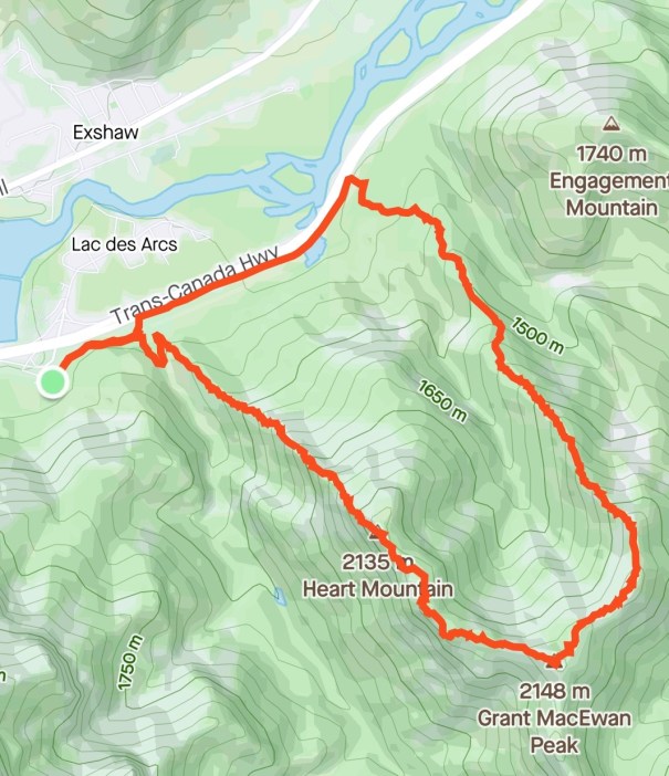
The Heart Mountain traverse is a horseshoe shaped loop with incredible views the entire way.Well worth the effort to go the extra distance.
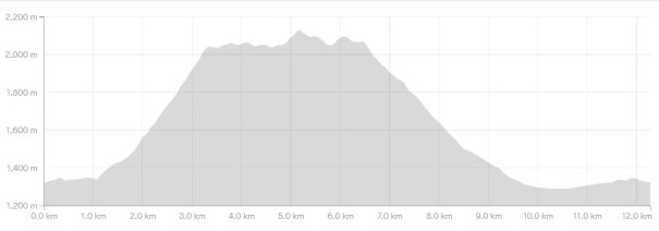
All the elevation is gained and lost in one extended push at the beginning and end of the scramble. The middle part on the traverse is very enjoyable with lots of undulations.
I love all things mountains! I live next door to the Canadian Rocky Mountains, however I travel the world to enjoy the many different mountain environments and cultures that I can. I hope you enjoy these trip reports, and that it inspires you to accomplish your own adventure goals.

We used to do this circuit a few times every spring and fall, but now we’re mostly at our place in Golden. I miss our old hikes like Heart.
It’s an oldie but a goodie. I bet you are finding all kinds of new gems in the Golden area. I do Swansea by Inveremere almost every year too. Close, a straight grind up, and done in a few hours.
I’ll have to look for it! There’s more biking than hiking or climbing near Golden so we’ve returned to biking for now, which is great.
I didn’t know that about Golden. I’m assuming mountain biking? I’m more of a road cyclist.
Oh ya mountain bike. We used to bike in Bragg Creek but had 10 years of dedicated climbing so we’re a little rusty.
Truly amazing experience my friend 🙏💙🙏
Thank you. It’s a blessing to live in this corner of the world, and being able to explore it.
The natural world is a version of natural magic at it’s best.. superb my friend 😉🙏💙