July 22, 2020
Apart from Swansea, Pedley Pass is the most accessible hike in the Invermere area on the limestone side of the Rocky Mountain Trench. If you want granite, then it’s the other side of the valley for you.
Time flies and things change! The last time I was at Pedley was about 10 years ago. My kids were eight, the road was near impassible without a 4×4 truck, and there was only one trail. Now the road is in pretty darn good shape, and there is a whole new route to explore!
Before, it was a There and Back route to Pedley Pass overlook, with a side trip to the little tarn. Now, there is a whole new section that takes you up and around a gorgeous ridge, which then connects to Pedley Pass and back to the parking lot. A big thank you to my friend Nancy for suggesting the route. I’m sure glad we hiked it!
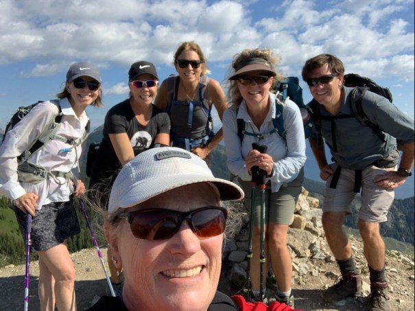
Today I met a whole group of women who love to hike in the Invermere area. In front is Barb 1, and in the back from L-R is Dani, Barb 2, Nancy, Alisen and Mike.
Gear
All your regular hiking gear – boots, pack and poles. There are no scree slopes, so no need for gators unless you go when there is still snow.
I might suggest a bathing suit and towel. My hubby Mike went for a swim, and I dipped in up to my knees. On a smoking hot day in summer, you’ll thank me for the idea.
Overview
From the parking lot, take the Pedley Ridge Trail. Climb the switchbacks until you gain the ridge. Follow ridge up and around to Pedley Pass. At the junction, either do the side trip to the Tarn, or continue on the trail to loop back to the parking lot.
Trail Head
As with just about any hike in British Columbia, getting there is half the fun (read: stress). As Pedley is located on an active mine and forestry road, I will not include driving instructions. Instead, I am linking to the local experts as they will have the latest updates on road conditions or changes.
We drove an all wheel drive Hyundai Santa Fe and it did great. If you are not comfortable doing the last 2 -3 km in your vehicle, there is no shame in parking lower down and walking up. Indeed, last time I was here I drove a Dodge Caravan. We had to walk the final distance to the parking lot. If two 8 year old girls can do it, so can you.

The trail head has a great trail description sign. It shows the whole loop route, and the side trip to the tarn.
Once at the trail head, there are two trail options. The trail marker at the NORTH end of the parking lot is the scenic and longer Pedley Ridge to Pedley Pass route.

To access the Pedley Ridge trail, go to the north side of the parking lot. While there are two paths, the sign clearly points to the one on the left.
The trail marker for the traditional direct route to Pedley Pass is on the SOUTH end of the parking lot.

This is the route I took 10 years ago. It is still the most popular route, as evidenced by the traffic. I highly recommend starting at the other end and doing the ridge.
Theoretically, you can do the loop in any direction, but I highly recommend starting at the north end at the Pedley Ridge trail and going clockwise. There are some quality switchbacks of which you can take advantage. The Pedley Pass route is straight up with no switchbacks. If you are short on time, then start at the south Pedley Pass trail head for a quick there and back trip.
Main Trail
Take the north Pedley Ridge trail head. Once on the trail, trek through luscious thick BC forest.

The start of the trail is a lovely walk through a thick forest.
After about 600 m, the switchbacks begin.

Despite the continual and extensive elevation gain, the switchback trail is delightful. It never felt too steep, and would be easy on the knees if you chose to come back this way.
We gained an obscene amount of elevation over the next 1.6 km or so of switchbacks, but it never felt too bad of an incline. You know you are nearing the end of the switchbacks when you finally get a break in the trees for a sneak peak at the view.

This is looking across to the Pedley Pass Junction. At the base of the ‘prow’ mountain is the entrance to the tarn.
Once the switchbacks ended, we traversed across the side of the mountain, passing a rock garden along the way.

This is above the switchbacks, as we traversed across the side of the mountain. The ridge starts above this.
After about 2.7 km, we made an abrupt right hand turn, and were now on the start of the ridge.

The final turn and we are on the ridge.

The ridge!!!
The ridge undulates down, and then back up a steep slope to gain the high point of Pedley Ridge.

This is the view of Pedley Ridge. It does undulate a fair bit, which of course means loss / gain of elevation. The high point ‘summit’ is on the far left with the large cairn just poking up.
This section is gorgeous. Remember look behind you to get a view of Mount Assiniboine on a clear day.

Looking back at our route on the ridge. Mount Assiniboine is in the far distance, in the upper right corner of the photo.

The summit of Pedley Ridge is the furthest left point. Pedley Pass Overlook is the round hump in the middle of the photo.
The ridge itself is rocky and interesting. The scenery generally takes your mind off the ascent.

This is probably the most scenic and enjoyable part of the trail. The rock formations change often, and the view never disappoints. We were very lucky with warm weather and just a very light breeze.
We arrived at the summit cairn of Pedley Ridge after 1 hr and 40 m of hiking. The elevation is 2,451 m with a gain of 465 m and 3.8 km of distance.

A worthy summit cairn mimics the shape of Mt. Assiniboine in the distance (far left).
From the Pedley Ridge high point, we continued along the undulating ridge to Pedley Pass Overlook.

The Pedley Pass Overlook is the large round bald spot. From there, we head down the ridge on the right, enter the trees, and beeline it for Pedley Pass Junction.
Pedley Pass Overlook is a wide open slope, and was the high point of the trail all those years ago. This is a very popular spot, as you can tell by the beaten down vegetation.

The Pedley Pass Overlook was once the end of the trail. If you are short on time, then start at the South end of the parking lot at the Pedley Pass trail head and make your way here. Then turn around to make it a There and Back hike.
It took us 2 hours and 8 minutes (about 25 minutes from Pedley Ridge) to hike here. The total distance is 5 km. Elevation is 2,280 m. We had a small bite to eat here, but decided to save our lunch for the side trip to the tarn.

The view from Pedley Pass Overlook down to Pedley Pass Junction. The Tarn is visible from here. It is the low point of the bowl across the way, just above tree line.
Pedley Pass Overlook to Pedley Pass Junction
From Pedley Pass Overlook, head straight down the ridge to the Pedley Pass Junction. This is about 1 km of distance.

Pedley Pass Junction from the Overlook. The trail to the right goes back to the parking lot. The trail on the left takes you to the tarn.
The Pedley Pass Junction is now extremely well signed. Blessings to the trail maintenance volunteers for bestowing their trail markers on weary travelers. Ten years ago, it was NOT clear which route took you to the tarn, and we added a few KM and a lot of unnecessary elevation loss/gain by going down the wrong valley. No need for that mistake now!
If you want to skip the tarn, then turn right at the Junction and head straight back to the parking lot.
Pedley Tarn
To go to the tarn, turn left (south) at the junction.

You literally cannot go wrong with these great signs. The Left arrow is pointing to the ridge we just descended. The straight arrow takes you to the tarn.
Then take your next immediate right (south west). If you continue straight south, that draws you down the wrong valley, as I found out the hard way years ago.

I could have used this sign 10 years ago. The trail guide book was none too clear, and we headed straight down the other valley for a good km or so before realizing our mistake.
Hike up to the high point, and then enjoy the long slope down to the base of the tarn. Hike through a small bumpy meadow at the base of the towering mountain.

You know you are very close when you reach the base of this gorgeous prow shaped mountain. The trail heads off to the right, and starts climbing through boulders and rock steps.
From here, we climbed up boulders and small rock steps to gain the outer rim of the tarn’s little head wall.

Yeah! We arrived at Pedley Tarn. My hiking partners are sitting on the little head wall that was gouged out by the glacier, and prevents the tarn from draining away.
From the Junction, it is about 1.3 km to the tarn. Total distance is 7.1 km, and about 2 hours and 55 minutes of total travelling time (including stops for photos and snacks).

Even if you don’t want to go for a full swim like my hubby Mike, you can still take off your boots and dip in your feet. After a long hike, there is nothing better than a cold foot soak.
Pedley Pass Return
From the tarn, return the way you came. I thought it was going to be a bit of a slog to get back up the hill from the base of the tarn, but the grade was actually quite nice. I think refreshing at the lake with food and a small dip made all the difference.
At Pedley Junction, we turned left (west) and made our way back the final 2 km to the parking lot.

This is the view from Pedley Pass junction. On the right is the ridge we came down. Behind us is the route to the tarn. Ahead to the left is the return route to the parking lot.
As it was now later in the day, and we were on the main trail, it started to get busy. Lots of people were coming up the trail. I was glad to be going down, because it was more or less straight up the ridge, with nary a switchback to be found.

By the shape of this trail, you can see it gets a LOT of hikers. The photo doesn’t do it justice, but the whole thing is just straight down. I was glad for the switchbacks on the other side.
We got back to the parking lot at 1:00 pm. It took us one hour from the tarn to return to the parking lot. Total hiking time was 4 hours and 20 minutes, including leisure time. Total distance was 10.8 km.
If you found this post useful, please do me a huge favour and click the Star button to “Like” it. You can also follow my blog, follow me on Instagram, or join my FaceBook page Al’s Adventurers.
Alisen
Totals – Tracked on Strava
Date: July 22, 2020
Group: Six (Alisen, Mike, Two Ski Friends Nancy & Dani, and The Two Barbs)
Distance: 10.88 km
Elevation: 680 m (2,244′) Includes all gains / losses.
Time: 4 hours 20 minutes (includes lunch and breaks)

Pedley Ridge connects up with Pedley Pass for a very enjoyable loop. Add in the side trip to the cute tarn to get the most out of your hiking day.

Once you gain the ridge, it undulates up and down quite a bit. The last high point on the right is Pedley Junction, The low point to the left is Pedley Tarn. There is some elevation loss / gain to get to the lake, but I think it’s worth it, especially because it’s all downhill from the junction.
I love all things mountains! I live next door to the Canadian Rocky Mountains, however I travel the world to enjoy the many different mountain environments and cultures that I can. I hope you enjoy these trip reports, and that it inspires you to accomplish your own adventure goals.

Looks beautiful!
It’s a beautiful part of the world. We are so lucky to be able to explore our own backyard.
Yes. The scenery here in Western Canada is spectacular. Today we hiked Grizzly Creek in k-country. The information on your previous post for this hike was very helpful. Perfect weather and amazing views!
Wow!!! Way to go! I absolutely love it when people try the hikes and summits. Grizzly is a great one. Excellent views. Thank you for the feedback. If there is something you want to try, please let me know. I’ve done more than is what is on my site. Cheers!
What a scenario!I wish if this picture can turn into alive in front of my eyes
Wouldn’t that be something! Remember when travelling was so easy? I’m sure you have any beautiful wonders in your own backyard. Now is a great time to explore. Enjoy!!!
As usual your photographs drive me crazy.Thanks a lot for sharing.Take care.🌹👍🙏
Thank you. You are very kind. The mountains bring peace to my soul.