June 30, 2017
July 6, 2020
Midnight Peak is a fun and accessible peak that doesn’t get a lot of attention due to it’s more famous neighbours, like Mount Baldy and Wasootch Ridge. I only found it because I was trolling satellite images along Highway 40, looking for a likely mountain to climb. Lo and behold – Midnight Peak was not only hiding in plain sight, but it was also included in Gillian Daffern’s Kananaskis guide book. I own the complete set of Daffern guide books, and so should you. When planning a hike, scramble or ski, I always go to the expert guide books first, and then follow that up with my online research.
The first time I hiked Midnight Peak, I don’t think I saw anyone else on the trail. This time, with everyone off from Covid-19, there were several groups on this trail. The majority were going to Baldy Pass, which is a lovely destination in itself. Only one other couple was on Midnight Peak.
Midnight Peak can be done as a There and Back hike, or you can continue down the long ridge line to make a loop of it. Fair warning: if you don’t like to bushwhack, or if you are not familiar with route finding, then the traverse may not be for you.
Gear
While there is scree, it’s consolidated so no gators are necessary in dry conditions. The usual boots, poles and backpack kit.
Skills required are good route finding, map & GPS reading, plus the ability to withstand a quality bushwhack.
Overview
From the trail head, hike straight up to Baldy Pass located between Mount Baldy and Midnight Peak. Turn South (right) and begin climbing up the back side of Midnight Peak. From the summit, return the way you came. To do the loop, follow the ridge line down. At the point of no return, turn north to follow a side ridge. This will eventually connect with the main Baldy Pass trail, which leads back to the trail head.
Trail Head
Park at the Baldy Pass parking lot. This is NOT the parking spot for the Mount Baldy scramble, which is further north. Cross Highway 40 at the cross walk. Do watch for traffic, as it’s a busy stretch of highway and frankly, no one is expecting a cross walk while doing 100 km / hr.

The Baldy pass parking lot is behind me. The trail starts directly across from the cross walk. Midnight Peak is poking up above the trees on the horizon.
The Trail Head is directly across the highway.
Main Trail
Hike up the trail from the highway. After about 800 m, there is a T junction. Turn left (up hill, easterly). There is a sign, but it’s on your left after you turn uphill. If you went right (and more or less straight – doesn’t show well in the photo), the trail continues to Wasootch Trail Head.

This is the junction. Turn left (East). The trail sign is on your left.

The one and only trail sign.

My hiking partner Annette is checking the sign against her GPS. A good hiking partner will always keep their own situational awareness!
The lovely soil trail is soon replaced by rubble, another casualty of the 2013 floods. This trail has seen some love though, and has been very well marked with cairns.

While the old trail is completely washed out and widened by the 2013 floods, there has been concerted effort to channel a trail. Look for the cairns (shown above) and flattened rock that will guide you through this area.

This is the original bridge across what must have been a cute little creek. Be aware here – you actually climb UP (to the right) at this point to remain on the trail. Look for the cairn slightly above the bridge.
If you are considering the traverse but are not sure about the bushwhack, then this is for you. At about the 1.9 km mark, check out the point where the traverse trail re-joins the main Baldy Pass trail. This spot is well marked by a log on the trail that prevents you from accidentally continuing down the creek bed.

At the point where you regain the old trail is where the traverse trail meets the main Baldy Pass trail. The log helps prevent you from continuing down the creek bed. Look directly across to the other side of the rubble bed. You will see the EXIT from the traverse.
Walk directly across the creek bed, and up the other side. There will be a very faint trail (which is more than you will get for the majority of this section). Look above this, and do your own assessment of the forest. If you are not completely turned off, then consider the traverse. If you don’t like what you see, the There and Back route is also delightful. Do NOT ascend here. This is the descent route from the traverse. Go back to the main Baldy Pass trail and continue hiking up.

If you are considering the traverse, I would recommend taking a look at return trail. As you can see, there is a little trail at this point. Trust me – it will NOT be like this the whole way. Also, this is the down track. Do not ascend this way, unless you are a mean mountain man like Bob Spirko, who goes up this way.
Once we were back on the main Baldy Pass trail after the log, we stayed on lovely soft soil for the rest of the way to Baldy Pass.
The trail follows the creek drainage for the first three KM or so from the parking lot. After that, the trail veers slightly to the right and starts to gain elevation in earnest, all the way to Baldy Pass.

Once the trail leaves the main creek valley, it heads right, up the side of Midnight Peak. It’s here that you start to gain steeper elevation all the way to Baldy Pass.
Baldy Pass is approximately 4.2 KM and 1 hr 25 m from the parking lot. I believe the elevation gain is 409 m (1,350′), but don’t quote me. Mount Baldy is to the North (on your left) . Turn South (right) to head towards Midnight Peak.

From the trail, looking up at the Baldy Pass giant cairn. At the top, turn right (south) to continue to Midnight Peak. The majority of hikers out today were making Baldy Pass their final destination for good reason. There are lovely views, and it’s a fairly quick drive from Calgary.
From Baldy Pass, there is a great view of Midnight Peak.

The route up Midnight Peak follows the ridge line on the left. It is a mix of trees and scree.
After just a few metres from the cairn at the pass, start looking for a faint trail that splits away from the main trail on the right (up hill). The main trail heads slightly left and down. Don’t feel bad if you miss it – I missed it both times! If you stay on the main trail, it will start to descend down the backside of the pass. Losing elevation when I needed to gain it was my first clue I had gone terrible wrong.
The reason I missed the trail is because it is hidden behind this giant rock. Simply skirt it to the left or right.

This giant rock kinda looks like a frowning troll’s head. Maybe an intrepid hobbit lived here years ago and outwitted the giant? The Troll Rock is hiding the trail – go behind and you will see the faint trail.
Once on this uphill trail, watch for a series of small rock cairns that will guide you up and around the grassy slope to the trees. These cairns are a huge improvement. Last time I had to hunt around, trying to find where the trail started at the edge of the forest.

This is directly behind the Troll’s Head. Follow the cairns up and around to the right.

The cairns take you directly to the trail entrance in the forest.
Once we entered the trees, we were now climbing up the spine of Midnight Peak. Do not expect any switchbacks or for the grade to ease off.

Annette making her way up the backside of Midnight peak. The trees were providing some blessed shade on this hot day.
Where the trees meet the scree, you have a choice. You can move out onto the rocks and follow that trail (which is indeed the main trail). As it was a very hot day in July, we elected to stay in the trees for as long as possible. We even found a pile of snow, which we used to cool off before exposing ourselves to the beating sun on the scree.

While Annette did a full body cool down, I filled my hat with snow and let it slowly melt. Heaven! I have also put snow down my shirt above my pack, and allowed it to slowly melt. I do not do well in very hot temperatures, so anything I can do to cool off, I will!
When we ran out of trees, we joined the weak trail that meandered through the scree. Stay left as much as possible, and avoid the temptation to be drawn to the right. The summit ridge is further left than you may think.

Once we left the trees, we had this amazing view to keep us motivated up the scree slope. While there is no definite trail lower down, the scree is fairly consolidated and doesn’t move very much. This is probably why there isn’t one main trail.
As we neared the summit, the trail magically consolidated into one definite trail. At this point, the scree trail was actually bordering on enjoyable.

Getting very close to the summit. There are now some plants growing, and the trail is consolidated straight to the summit. Fun Fact: Midnight Peak is higher than Mt. Baldy! This is the view of West Baldy, with the main summit to the north.
The big hint that we were almost at the top was the start of vegetation growing. A few meters up from this greenness, and we suddenly popped out on the ridge just below the summit. I say “suddenly” because both times I was surprised. Usually you can see the end coming, and while I knew I was close to the top, having the mountain abruptly end was unexpected.
From this point, turn right and hike up the final few metres to the summit of Midnight Peak.

From the summit, looking back at Annette. When hiking up, you just pop out on this narrow ridge.
It took us 3 hours to reach the summit at a very leisurely pace. Distance was about 5.9 km. Elevation at the summit is 2.319 m, with a gain of 911 m (3,006′).
Midnight Peak has the cutest summit register box ever! I love it that someone took the time to not only haul this metal box up there, but decorated it too! If you have little girls that like to hike, please take them up here!

The summit register box is an old army box painted bright pink and covered with rainbow and unicorn stickers. This is just the cutest thing I’ve ever seen on a mountain. If you bring your daughters up here, please put a photo in the comments section!!!

The views from the summit are amazing. Baldy is beside you (see photo above). To the left is Midday Peak, and beyond that is Wasootch Ridge. Across the valley is Nakiska Ski Resort.
Midnight Peak Return
Once you’ve enjoyed the view, take a moment to wander up and down the ridge for a bit. It’s nice and wide, and fun to stroll along. To return, go back the way you came and descend the scree.
Midnight Peak Traverse
From this point, Bob Spirko describes this as a scrambling route. While it is easy to avoid any hands on rocks action, it does require good route finding and GPS skills.
From the summit, head west down the ridge. You are now more or less paralleling the hiking trail to Baldy Pass.

The summit is behind me. We will continue all the way down the ridge line for a good 2 km.
The ridge undulates up and down over a span of about 2 km. Some of the down sections are steep slabs with ball bearing rocks. Be mindful to stay on the spine of the ridge, and avoid meandering down either side.

Looking back at the descent from the summit ridge.
At around 6.5 km, there is a large formation blocking your way. You can scramble up it, or simply go around it to the left. Your choice. I’ve done it both ways, and it’s just what you are comfortable doing.

Annette approaching the small scrambly bit. As you can see, the trail skirts it to the left.

Annette snapped this shot of me approaching the scrambly bit. Lots of steps to clamber up.
This ridge has a lovely selection of endangered White Bark Pine trees. These are very slow growing, late maturing trees. They are “planted” by the Clark’s Nut Cracker bird who stashes the seeds, but then forgets to eat them later. These trees are usually the first to grow on wind-swept steep faces, and provide the necessary snow cover to allow junipers and spruce trees to grow.

The White Bark Pine is right in the middle. A spruce is to the left of it. This is not an upright spreading tree, but actually several trees together. The Clark’s Nut Cracker always deposits several seeds. The multiple trunks is one way to tell it’s a White Bark Pine. Also, it’s needles grow upright, encouraging birds to land on it.
At around the 7.7 km mark, it is now time to leave the ridge, and head north. You can recognize this spot, because the ridge makes a Y junction. If you continue straight (and slightly left) this will draw you away from the parking lot, and deposit you in bushwhack purgatory.

This gorgeous outcrop marks the end of the ridge trail. It’s now time to turn north, and pick up the ridge that Ys to the right.
When we turned north, we were still on a ridge, albeit a wider one.

Looking down onto the next ridge, this one heading generally north. This ridge eventually connects with the Baldy Pass trail.
The trail here was still pretty darn good, following the undulations of the ridge. We went up a few steep rock outcrops, which were absolutely gorgeous! I love it when a trail throws up little bits of beautiful micro-scenery to marvel at. I love to bag a summit, but for me, I love a good rock formation strategically placed for optimal viewing enjoyment.

This is one of a couple of gorgeous rock formations we found along the way. It is so important to take joy in the little things, to help remove any memory of the heinous bushwhack yet to come.
The bushwhack section starts in earnest after crossing a small meadow. Why the fairly strong trail decides to disappear at this point, I don’t know. My strategy to deal with it is two fold: one, I reminded myself that the actual full-on bushwhack section is only about 1 km. Two, I always maintained the crest of the ridge. The trees were a bit lighter up there, and it prevented me from going too far left or right, which would drag me away from the promise of the hiking trail below.

The end of any discernible trail, and the start of the very steep bushwhack section.
The bushwhack section is very steep and uncomfortable. Please pick your hiking partner carefully. My long term hiking partner Annette is amazing. She never complains about anything, and handled the bushwhack like an old pro. She had the GPS, and would continually check that we were more or less on track. This is not always the case. The first time I did Midnight Peak, my partner complained the whole way down. Yes, bushwhacking bites, but it’s not the end of the world. Suck it up, sunshine.

The bushwhack. After doing some real quality bushwhacks in the interior of BC, this is really not that bad. However, it is steep. Strava recorded grades between 25 and 48% for this one km section!
At around the 9 km mark, start looking for the creek gully, which will be dry later in the season. It “should” be on your left. It’s now fairly easy to maintain the ‘trail’ as the gully is on your left. Sometimes the trail will take you down into the gully, but be sure to come back out to the right.
The creek gully will lead you directly to the main creek bed, and the Baldy Pass hiking trail. Here, Annette and I took a small break to celebrate being out in the open again. Then we turned left (west) and made our way back to the parking lot.

The end is near! The dry creek gully spat us out right onto the Baldy Pass hiking trail. From here, turn left (west) and return the final 1.5 km to the parking lot.
I like to classify routes into two categories: Yeah, I’d Do That Again, and Never Again. Midnight Peak is firmly in the Yeah, I’d Do That Again camp.
If you found this post useful, please do me a huge favour and click the Star button to “Like” it. You can also follow my blog, follow me on Instagram, or join my FaceBook page Al’s Adventurers. If you hiked this route, PLEASE leave me a comment and tell me how you did. If I need to update anything, also please let me know.
Alisen
Totals – Tracked on Strava
Date: July 6, 2020
Group: Two (Alisen & Annette)
Distance: 11.2 km
Elevation: 883 m (2,914′)
Time: 4 hours (includes lunch and breaks)
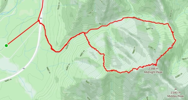
Park in the Baldy Pass lot, then cross the highway to start the route. A quick hike up to Baldy Pass is also very enjoyable with fantastic views, if you don’t want to climb the whole mountain. Return the way you came, or consider doing the traverse IF you have good route finding skills and don’t mind a quality bushwhack. Please ignore the Strava straight lines at the parking lot. They are not included in any of the totals or distances.

As you can see, it is a fairly reasonable elevation gain up to Baldy Pass, but then it’s pretty intense once you start up the back side of Midnight peak. On the return, the final bushwhack section is by far the steepest, just to add insult to injury 🙂 The low angle for the last 1.5 km is the regular hiking trail back to the parking lot. Ignore the distance past the 11 km mark.
I love all things mountains! I live next door to the Canadian Rocky Mountains, however I travel the world to enjoy the many different mountain environments and cultures that I can. I hope you enjoy these trip reports, and that it inspires you to accomplish your own adventure goals.

Neat 🙂 oh I wish my knees still worked right 🚶
Oh, I know how you feel. I have to work so hard to keep my knees in shape. Lots of cycling and using poles are the two things that have helped me.
Do you need a knee replacement?
I’m not going threw replacement at my age. I just cut back on hockey playing and downhill ski racing 😉
Racing – yeah, that would be hard on your knees.
That’s a fun hike. We’ve done it in reverse. We’ve also seen people get to or near the summit from Baldy Pass and then freak out on the descent, having lost the trail.
I believe it. I was trying not to over sell the traverse for that reason. Scramblers will have no trouble, but pure hikers might be caught out. It’s a balance.
Yes exactly, you added enough sensibility.
Thank you. I appreciate the feedback. I never want to discourage someone from going, but also don’t want to give a false sense of security. As you’ve done it, AND seen the disastrous results of unprepared hikers, I appreciate your honesty.
Your photos looks awesome!
Thank you. The scenery does the hard work 😁
Hiking is always so fun!!
Absolutely! The mountains are my peaceful and happy place. You too, right???
Great work 👍