May 12, 2019
I absolutely love being in my Rocky Mountains, and I’m even happier when I get to hike or scramble something. However, I have to say that Anklebiter Ridge was not my favourite, which saddens me. I’m sure a big part of it was because it was Mother’s Day, and for the first time ever since I became a mom, my daughters were not with me. They were both working and buried in homework as they headed towards the home stretch and finals. My hubby Mike took me out to do this scramble, which I would normally love, but not today.
The other thing that got to me was the incessant banging from the operations below. Now, I am NOT complaining about it. It is a business that provides employment and a needed product. If I don’t like the noise, I can hike elsewhere. Maybe on any other day, I wouldn’t notice it, but today, well, it got to me. Just saying.
What I DID like about Ankelbiter was it’s close location – it’s in the front ranges, so it’s quick and easy to get to. There is a nice little warm-up approach, which I think is needed considering the rest of it is literally straight up. There is also lots of interesting scrambling and route finding to keep everyone entertained. On the whole, this route has a lot going for it.
Overview
I believe the reason it’s called Anklebiter is because it literally takes a bite out of your ankles. The grade is mostly over 40% and sometimes up to 50%. For 1.5 km, I had gained over 500 m. Boy, my achilles were aching! You start at the Grotto Mountain Pond, and take the short connector trail to the start of the scramble. Then you turn right, and head straight up until you hit the summit.
Trail Head
Take Highway #1A to the Grotto Mountain Pond parking lot on the north side of the road. From here, find the trail heading straight west out of the parking lot. Stay on this trail for 200 or 300 m.

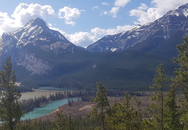
A view of Anklebiter Ridge from the Grotto Pond parking lot. I believe this is just the false summit, and the real one is set further back and out of view.
Next, turn right onto a well marked trail. Please note that there are a LOT of trails through here, all of them well worn from use, and all going to different places. Stay on this connector trail for about 150 m.
There will then be another right turn – this is now the start of the trail leading up Anklebiter ridge.
Scrambling Up
The scramble up Anklebiter is quite enjoyable. There are also quite a few slabby rock sections. These can be intimidating, and make travel a bit dicey.

Alisen coming up one of the fun scrambly bits. You can see the Bow River and the 1A highway directly below. Despite being quite high elevation, I haven’t really gone anywhere in terms of distance from the parking lot.
There are a lot of small rock bands to go up and over, and the views across the valley are just amazing. If you ever need a breather, just stop and look around.
A great view of Mount McGillivray (left) and the hard side of Pigeon Mountain (right).
While Mike and I enjoyed this challenge, not so the other two groups we encountered. The first was a group of 20 something guys that weren’t able to make it past the first rock slab. They were turning around, and made it pretty clear that an “old woman” like me could never do it. Pffft. Whatever.
Also on the lower section, we found two young guys without shirts, badly off route. We think they were after rad instagram shots, but they had somehow gone too far west, and were trying to cliff themselves out above the canyon below. We called to them so they could come back up onto the route, and were very happy to find it again.
At the 2.5 km mark, we hit the first flat area since heading up. This was an absolutely delightful but short-lived stroll through an open forest with interesting trees trying to survive in this windy and harsh environment.

The trees have a hard time trying to survive up here. The wind was incredible all day, and several trees had been hit by lightening, like this one.
After about 150-200 m, we began the final push to the summit of Anklebiter Ridge. We reached the summit in 2 hours and 30 minutes, gaining 810 m (2,673′) in just over 3 km.
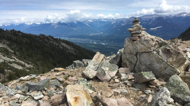
The summit of Anklebiter Ridge. Mike and I ate lunch down below this marker to get out of the wind. The ridge in the background is the optional loop.
Return Trip
There is a loop you can do, but I had forgotten to put my shoe liners into my boots (they were in my backcountry ski boots), so I wasn’t relishing the extra KMs with no foot protection. So, maybe this was another factor why I didn’t love this route. Anyhoo, we retraced our steps back to the car.

Looking down at the false summit, Mike is pointing to the one little bit of flat on this whole route. The mountain panorama in the background is just outstanding.
But it’s not that straight-forward. While the way up up pretty steep, so was the way down. What made the descent pretty nasty were those rock slabs. Now, on mountains like Heart, these rock slabs have been more or less ‘cleaned’ by thousands of hikers. Not so here. The slabs have millions of little rocks that act as slippery ball-bearings. Mike actually took a bit of a fall, which is very rare for someone like him who is half-mountain goat.

Mike’s cut doesn’t look too bad, but it was deep and he still has the scar.
By this time, the incessant pounding at the works below was wearing down my mental capacity. I felt more tired that I should have, for such a short day out. What’s interesting though, is that as soon as we got into the valley and out of hearing range, I immediately perked up and felt 100% again.
Anklebiter Ridge is a short scramble, very conveniently located, and easy to access. However, it is still a scramble and should not be underestimated.
Totals – Tracked on Strava
Date: May 12, 2019
Group: Alisen & Mike
Distance: 6.36 km
Elevation: 810 m (2,673′)
Time: 5 hours

As you can see from the tight contour lines, this route is all about the vertical in short span of distance.

And this tells the story of the unrelenting elevation gain. The little flat spot near the summit is only a few hundred meters long, but was still very welcomed by my aching calves and achilles tendons.
I love all things mountains! I live next door to the Canadian Rocky Mountains, however I travel the world to enjoy the many different mountain environments and cultures that I can. I hope you enjoy these trip reports, and that it inspires you to accomplish your own adventure goals.

Leave a comment