June 10, 2019
June 24, 2019
I am always looking for fun and easy hikes to take new hiking friends on. The route needs to have an easily attained elevation gain, in the front ranges, and with some pay off at the end, like a summit view or gorgeous lake. Gunnery Peak checks all these boxes. However, both times I visited this peak, I managed to make this trail way harder than it needed to be.
On my first trip, we could not find the cut off to get away from Gunnery Creek and start heading back up the mountain. We ended up WAY too high, and our cute little hike turned into a full on route-finding adventure with lots of scary drop-offs.
On the second trip, I knew the route, but I messed up with hiking partners. I allowed ‘a friend of a friend’ to come along. This was a big mistake because the friend could not (or would not???) go downhill. Even the easy grade along the creek was too much. What should have been a quick half-day hike turned into an epic as this woman crawled her way down the mountain, moaning about her one million ailments the entire way. I must give kudos to my friend Sue who took the brunt of the moaning. This was my bad, as I should have spoken to the ‘friend of a friend’ in person before allowing her to come.
Overview
The trail up Gunnery Mountain is much like Pigeon Mountain, in that it is super simple navigation. From the trail head, you follow the creek to its end, then turn left. Then go straight up until you hit the south lookout over highway 40. From the lookout to the summit is a bit trickier as you need to pick your way up through the trees, with no real trail. The summit has a nice cairn and lookout, and you get inspired looking across at Holy Cross beside you.
Trail Head
From the north, take Highway 40 to the area formerly known as Eerie Gap Day Use area. I know this sounds like “turn left where the old barn burned down 20 years ago” but the gate is still there. Go past the gate, and look for the first creek on your left (north side of highway). Turn around, and park on the flat area just past the creek. If you hit the Sentinel Day Use area, turn around.
From the south, go past the new Sentinel Day Use area that was created after the 2013 floods. Look for the first creek on your right (north side of highway). Park in the open area on the right, just past the creek.
The Trail Head is to the right (east) side of the creek, marked by a nice sized cairn.

Cairn at the trail head, above and to the right (east) of Gunnery Creek.
Main Gunnery Creek Trail
From the trail head, follow the well established trail to the right of Gunnery Creek for about 3 km.

Gunnery Creek on the lower sections of the trail is just gorgeous. Further up, it will be just a trickle, so enjoy these views.
You will gain some steep elevation almost immediately, but then the trail lays back and it is a most enjoyable trip. The trail is interesting, the views are lovely, and the hiking is easy.

Looking down on the main Gunnery Creek trail. The trail is a mix of trees, open meadows, and various creek crossings.

From the Gunnery Creek trail, looking up at the Gunnery Mountain trail. The trail is in the band of trees half way up. On our first attempt, we were really high, and went along the base of the sheer wall above the trees.
The connection with the Gunnery Mountain Trail is a bit tricky. The main Creek trail continues north to the pass, and a lot of people make this their day trip destination. It’s easy to walk right on past your turn-off.
At about the 3.0 km mark, the creek turns left as it drains down from the mountains to the west. This is the cue to leave the main trail, and start working your way up the creek bed.
On my first attempt, I didn’t know to head up the creek bed, and kept on the main Creek trail too far. When I did turn west, it was a full-on bushwhack through the trees. I tried to intersect with the summit trail, it is very faint at this point.
Knowing we missed the connection with the summit trail, we decided to keep climbing up until we hit the cliff band. From here, we traversed across under the rock band until we connected with the main trail at the saddle. I believe this is actually a trail, or at least a LOT of other people have found their way up here before me. So that was some consolation for my bruised navigation skills.

I am really proud of the group on our first attempt up Gunnery. This was either their first or second hike, and despite the bushwhacking, heights and lack of a trail, they had a great attitude and were all smiles. Rob here is going for it!
On my second attempt, I did turn left (west) at the creek bed. Yeah! The easiest navigation is to stay with the creek bed until it intersects with the summit trail. There should be some flagging or other markers to indicate the intersection.
At the intersection, turn left again (south). On my way up, I elected to take an earlier cut off from the creek, which was fine, but it did mean a bit of bushwhacking to get back onto the summit trail.
Once you gain the summit trail, it is a straight shot heading south until you arrive at the lookout saddle. This trail is in great shape, and for the most part the elevation gain is at a very nice grade. There are a couple of steep spots, but that’s it.
The lookout saddle is about the 4 km mark. Gunnery peak is to the east (view blocked by trees), and the giant mound of rock to the west is Holy Cross Mountain.

The view of Holy Cross Mountain is stunning and inspiring.
From Saddle to Summit
From the saddle, we made our way east uphill. We found a lovely mound of flat boulders. This marks the spot to continue east, across a small meadow and enter the forest. There is a cairn that marks the entrance into the forest with a faint trail heading up the side of Gunnery Mountain.

This is the meadow above the saddle. Rob is sitting on the big flat boulders. The entrance to the forest with the cairn is directly behind me.
After working our way up through an open forest, we came to another flat spot, with a little lookout to the east.
From here, we continued south and went uphill until we hit the summit of Gunnery Mountain. There is no real trail here, it was just a matter of heading south and up until we hit the top.

This is the east view lookout and Gunnery summit is directly right (south). This was Linda’s very first hike and she nailed it! Big smiles and amazing attitude despite the tricky trail. She will probably kill me, but Linda was just shy of the big 7-0 here. You are never too hold to hike!
The summit has a lovely cairn, that was made with much love and care. Thank you! There are great views to the east, south and west. In addition to the views, there are enough trees up here that we could enjoy our lunch in comfort.

Gunnery Mountain summit cairn. This is the view to the south west, with the Highwood River below.
The distance to the summit is about 5 km, with an elevation gain of 582 m (1,920′). Time to summit was about 3 hours, at a very relaxed pace for the new hikers.

This is looking to the north from the summit with Deb, Annette, and Sue. The forth person would soon try the patience of a saint as she crept down the trail. Lesson learned: I will never bring an unknown hiker unless I speak to them in advance. My bad.
Gunnery Mountain Return
From the summit, I found a bit of a trail heading down. I followed this as much as I could, and then found some flagging in the trees. I followed these for a more direct route back to the meadow above the big flat boulders. The exit was to the left (south) of the entrance cairn.
From there, we simply retraced our steps back down the trail. We kept straight until we hit the creek intersection. We turned right and picked our way down the creek bed until we hit the main trail. From here, we turned right (south) again and made our way back to the vehicle.
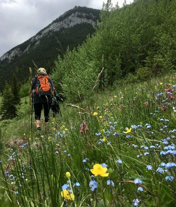
Annette framed the abundant wildflowers and hikers beautifully.
Gunnery Creek is conveniently located at the end of the trail, so I was able to take off my boots, soak my feet, and splash the lovely cold water on my face. That is the best way to end a hike!
Gunnery a super little mountain, and would be a great thrill for a new hiker or young children to ‘bag a summit’ especially one you can see from the highway.
Happy Trails!
Alisen
Totals – Tracked on Strava
Date: June 10, 2019
Group: 5 (Alisen, Mike, Rob, Linda, Willy & Zoe)
Distance: 10.93 km
Elevation: 641 m (2,115′)
Time: 5 hours
Date: June 24, 2019
Group: 5 (Alisen, Annette, Sue, Deb and Friend of a friend)
Distance: 10 km
Elevation: 582 m (1,920′)
Time: 6 hours 45 minutes (3 hours up, so longer down than up)
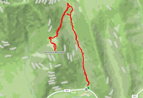
This is the map for the second trip with the ‘correct’ navigation. We turned west at the creek, and took the lovely trail up to the saddle.
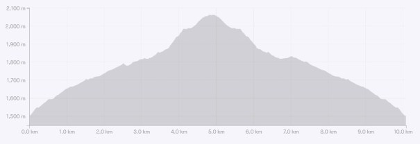
The elevation gain for Gunnery Peak is very mellow, with just over 580 m (1,920′) of elevation gained over 5 km. This is an incredibly do-able mountain for all ages, abilities and fitness levels.
I love all things mountains! I live next door to the Canadian Rocky Mountains, however I travel the world to enjoy the many different mountain environments and cultures that I can. I hope you enjoy these trip reports, and that it inspires you to accomplish your own adventure goals.

Great post 😊
Thank you! Much appreciated.