July 15, 2018
As my daughters get older, I realize that they are not going to be with me forever. They are strong, capable young ladies who want to strike out on their own adventures. I encourage their free spirits, so whenever I can get a day with them in the mountains is incredibly special to me.
This summer, my kids will be going on a month-long Leadership camp at the YMCA Camp Chief Hector. They will be backpacking for 18 days straight. If that’s not amazing enough, the kids will plan their own route, select, make and pack their own food, and choose their gear. They will carry everything themselves, and have nothing but a map and compass to navigate through the mountains.
Our trip up Pigeon Mountain will be easy for them, but one full of interesting natural history.
Overview
Route finding on Pigeon Mountain has got to be one of the easiest in the Rockies as you literally only make two turns. Once you’re on the mountain proper, the scenery is interesting and you can see back into our ancient geologic history. I also highly recommend this route for trail runners, and I think it would be much better than Prairie Mountain.
Trail Head
From the #1 Highway, take the Dead Man’s Flats overpass and go South on the George Biggy Sr. Road, heading towards the condos at the base of the old ski hill. On the right hand side is a parking lot and day use area with outhouses.
Main Trail
At the far end of the parking lot, continue past the roundabout, and head south on the main trail.
In about 200 m, turn left (south easterly) at the major junction. This is a wide cut line called the Skogan Pass Track that parallels Pigeon Creek. This is the power line between Canmore and the facilities in Kananaskis Country, including the Nakiska Ski Area.
I think this is a good route for trail runners because it’s very wide, has a double-track for talking, a nice, even elevation grade, and is so boring I just want to race through it!
At about the 4 km mark, the trail will FINALLY stray away from the cut line, enter the forest on your left, and start some easy switchbacks at the base of the ridge.
At the 4.9 km mark, there is a cairn on the left. This is your cue to leave the main trail, and start climbing. This trail will now take you all the way to the top of Pigeon Mountain.
Sound super easy? It totally is. Almost too easy. There were two women in front of us, and they chit-chatted right on past this cairn. We didn’t see them again until we were well off the summit and heading home. I asked if they made it all the way to Skogan Pass, and I believe they darn near did! We are all out here to get some exercise and enjoy the scenery, so good on them for getting in the extra KMs!
Pigeon Mountain Trail
Once we gained the actual Pigeon Mountain trail, life instantly improved. If I could magically transport myself to the base of this mountain, I would do it again and again.
First off, we climbed this beautiful steep meadow ridge. It’s a wide double-track, and it reminded me of the tractor tracks in fields, if fields were vertical.

Mackenzie motoring up the initial incline on Pigeon Mountain. This trail is badly braided, but the wild flowers and wide open meadow was simply gorgeous.
Above this, we were treated to a most interesting sight. Below the rock wall are some very, very old moraines! Normally, the moraines we see are from the last ice age, and are grey rock that has “recently” been tumbled. These moraines were from an even earlier time frame, because they had lots of time to completely grass over. They now look like little hummocks.

At first I could not figure out what these hummocks were. After trudging through, up and over, I finally realized they are ancient moraines, now grass covered. This is a glimpse into the future of our Rocky Mountains.
Have you sat at the base of a terminal moraine with a little tarn at the bottom, and wondered how deep the water was? Well, come on up to Pigeon Mountain to find out.

On the way back, we got some perspective on the old moraines, and the depressions that would have held ancient tarns.
If there was one thing we didn’t like about this route, it was the swarms of biting black flies. I really don’t know what they are, but they are nasty! At first we just thought they were landing on us, and tried to ignore them. It wasn’t until later we noticed the itchy bite marks. We quickly put on bug spray and were immediately left alone.
From the cut-off cairn, it is only 3 km to the summit of Pigeon Mountain.

The long open meadow past the rock wall and ancient moraines. This view stretches on towards the summit, with a straight climb to the summit.
After about 7 KM of steady climbing up the side of the mountain (2 kms from the cairn) we hit the summit ridge. This is a very enjoyable wide ridge with lots of picking your way through rocky areas.

The summit ridge is gorgeous. If that isn’t enough, check out the views down into the Bow Valley below.
The summit of Pigeon Mountain is a bit of an anti-climax. We just sort of ‘arrived’ with no fanfare or difficult rock band to overcome. This is fine by me, because there is more than abject terror to make a hike enjoyable. Pigeon Mountain ticks a lot of boxes – Easy navigation. A real ‘hike’ the entire way. It’s a summit, with great views. Lots of KMs, and decent elevation gain so you feel like you did something.

The Pigeon Mountain Summit Cairn, and a great view looking south.
The summit provides excellent views of mountains you have already done, or ones on your Tick List.

Looking north from the summit of Pigeon Mountain. Below is the TransCanada highway into Canmore. On the left is Wind Ridge, Wind Tower, the Three Sisters, and even the pointy tip of Ha Ling.
My daughters and I arrived at the summit of Pigeon Mountain in 2 hours and 40 minutes. It was a total of 7.8 KM, and an elevation gain of about 979 m (3,203′).

As my twin daughters grow up, I’m thankful for the great times and experiences we’ve had in the mountains. This is our “Mother-Daughter” time and I wouldn’t trade it for a spa day ever!
Another nice thing about this trail was it was mostly women. Two women were coming down as we went up, and there was another mother-daughter duo coming up after us.
Return Trip
On the way back, I noticed you could go up the smaller, south summit. We were heading that way when we saw a herd of mountain sheep on the shoulder. I really do not like to disturb wildlife when I can help it. The males were keeping an eye on us, so we decided at the last moment to skip it.
Not going up the south summit, I wish I had taken the Bob Spirko return route, and descended directly from the summit to the old ski hill to save some KMs. However, we were here to get some exercise, and my girls needed to put on lots of KMs to get ready for their giant backpack trip.
Back on the cut line, it was now early afternoon and the day had really heated up. We were roasting as we trucked down this long stretch. I think we found some water in the creek and splashed around for a bit to cool off. I’m glad we stared and finished early!
Happy Trails!
Alisen
Totals – Tracked on Strava
Date: July, 15, 2018
Group: 3 (Alisen and her twin daughters)
Distance: 15.7 KM
Elevation: 979 m (3,321′)
Time: 4 hours 45 minutes
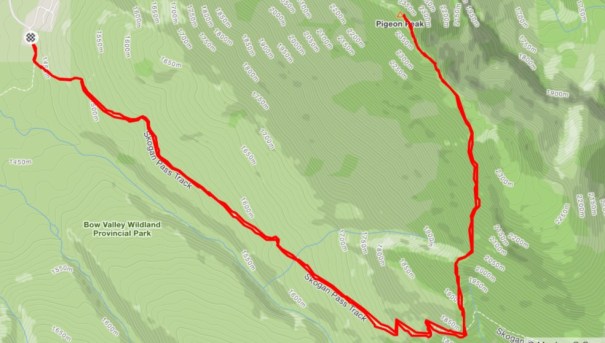
As you can see, the trail is very straight-forward and easy to navigate. Lots of KMs and elevation make for a full day in the mountains.
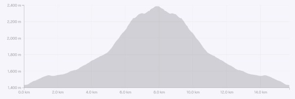
I love getting a full 3,000′ of elevation gain per hike, and Pigeon does this, and a little bit more. The profile looks steep, but the actual Pigeon Mountain trail was so interesting, I never really noticed the gains.
I love all things mountains! I live next door to the Canadian Rocky Mountains, however I travel the world to enjoy the many different mountain environments and cultures that I can. I hope you enjoy these trip reports, and that it inspires you to accomplish your own adventure goals.

Leave a comment