November 15, 2019
I have been eyeballing South Lawson for years, but never knew the name of the mountain. Every time I came down off the Smith Dorian highway, I get this absolutely perfect view of a ridge. I finally figured out it’s name, and made plans to hike it.
I am not a winter hiker / snowshoer. I am a back-country skier, and as soon as the snow flies I much prefer to be on my boards. I’m not a total snob though, and since some friends wanted an adventure in the mountains, I was gung-ho to lead this trip.
The hardest part was figuring out the proper gear. It was -6 C at the parking lot, but the ridge was shrouded in cloud. I didn’t have high hopes for solar heating. I have already frozen my toes twice this winter, so wanted to ensure my feet were well protected. Also, I didn’t know how much snow was going to be up there. I was post-holing up Mist Mountain in October and really didn’t want a repeat of that. In the end, I brought it all.

The view of the South end of Mount Lawson really is majestic. The col, false summit and summit are well outlined on the right.
Gear
For shoes, I wore my regular Solomon hiking boots. They are lightweight hikers with vents on the top of the toes, so not ideal in the winter. I covered these with my Boot Gloves that I normally wear over my ski boots. Fantastic idea, if I do say so myself.

These neoprene boot covers block all wind, provide insulation, and keep the snow off my boots. They have saved my feet skiing in the winter, and today they worked great on my hike. When it is really cold, I will put a heat pack between my boot and the boot glove.
I was very worried about frostbite, so I purchased a pair of Lenz heated socks the night before. They are expensive, but they work. I kept them at the lowest setting, just enough to keep the chill out.
Micro-spikes was a given. I have the gnarliest pair MEC sells, and they worked great.
Since I was unsure of the snow depth, I borrowed a pair of snowshoes. We strapped our snowshoes to our packs, where they stayed secured all day. I’d rather take snowshoes for a walk, than to turn around because of an unexpectedly deep snow pack.
Overview
The trail starts at a pullout off the Smith Dorian trail. From here, walk beside the spillway until you reach the end. Turn right, and start gaining elevation up the ridge. Continue straight up the ridge, past the col, and the false summit, until you reach the true summit. Return is the same route.
Trail Head
Access the Smith Dorian highway from the south end, across from the Pocaterra Ski Area. Stay on the Smith Dorian for 2.9 KM. Look for a cross-roads, and turn right here. Park off the highway in the little clearing.

Park on the north side of the highway. In the summer, the campground is open so not sure how much space is available on the south side.
Go around the Closed Gate, and start down the road next to the spillway.

This is the pull out on the north side of the highway. Lots of room for several cars to park.
Soon you will have the flume on your left for company.

A flume is an above ground waterway. I assume this one was built for logging back in the day.
Stay on this track until the very end. It’s obvious because of the giant water displacement equipment. This flat trail is about 1.4 km long.

End of the line. Turn right now to cross the creek. There are two tracks – one goes straight up the ridge, the other follows the snowshoe trail for a little bit before turning up the ridge.
Turn right (east), cross the small creek, and immediately begin ascending the ridge.

Rosalie crossing the creek.
Main Trail
The trail up from the spillway goes from zero to as much as a 40% grade, but the average is about 20%. It is an uninspiring slog up through a closely treed forest with zero views. Thankfully I was with excellent company who chatted the whole way, regardless of the steepness.

This is the view for the entire lower section.
The lower section of the trail had some light snow. We wore spikes because of the frozen ground and some decidedly slippery spots.
We only came across one bare section, but that didn’t last long. We kept our spikes on and tread lightly.

The one bare patch on the entire trail. It must be in full sun.
After about 1 hour and 15 minutes, we got our first views over the ridge to the mountains on the east side.

Just a glimpse, but we were happy to have it.
From here, the snow really started to accumulate. There was a storm system the previous Sunday, when I was backcountry skiing at Arethusa. There was some traffic on the lower slopes, but it petered out once the snow got deep. I was in for some quality trail breaking.
We entered a bit of a Winter Wonderland. Hoar frost dusted the trees, and the cloud cover preserved it beautifully. The trail was sometimes hard to pick out, but since it’s a ridge…

The sun was just starting to come out, highlighting the beautiful frost on the trees.
Higher up, the trail took us directly beside the ridge. Here the trail started to undulate a bit, with nice previews of the following steep sections.

A good view of the ridge. In full winter, you should be able to see the cornices build up.
Just before the col, we were finally high enough to get into larch territory. It was a funny fall, and many of these trees still had their needles.

The forest was mainly spruce, however I did find some White Bark Pine on the open slopes, and some larch trees up above.
The col was in great shape, despite the snow getting deeper.

The ridge continues across the gap. The col is to the left.

Alisen and Rosalie on the edge of the col. I must be deciding upon my ascent route.
After the col, I stayed as close to the ridge as I could because the snow was decidedly less deep here. This is a north-south ridge, so it does get cornice build-up on the east side due to the westerly winds. I was careful to check for cornices, but none had formed so early in the year. Later on, be sure to stay well back from the edge.

View of ridge. I basically went straight up, as the snow was too deep to switchback.

No cornice build-up. Check out that view! Kananaskis Lake look amazing. We were so lucky the cloud had burned off our peak.
Once past the col, we were now above tree line. Thankfully the clouds had cleared, and we had some amazing views.
We continued on the steep ridge to the false summit.

This feels like it should be the end of the trail.
Past this, we descended a short bit and crossed a narrow section. When I tried to step across it, the snow had already started to soften and was slippery. I decided to avoid it altogether by going down a bit to the west.

Sonya took a picture of me being safe, and avoiding the narrow bit with slippery snow.
The final push to the summit was through virgin snow. I did break trail to about mid-calf deep, but it wasn’t too bad nor too long.

Summit cairn is on the horizon. Ah, glorious fresh snow. Almost a shame to mess it up.
The summit of the Sound end of Lawson does not disappoint. It is a magnificent 360 degree view.

NORTH: A grand view of Mount Lawson’s north peak. On the left, Mount Kent stretches into Mount Inflexible.

WEST: The south end of Mount Kent is in the foreground. The Smith Dorian highway is on the other side. Beyond is Mount Black Prince, a popular backcountry ski location.

SOUTH: Mount Wintour stretches into the distance. Beyond is Gap Mountain.

WEST: King Creek Ridge is looking good. To the left is Mount Packenham.

Still looking west, Grizzly Peak with Mount Evan-Thomas behind it. Opal Ridge South is the next mountain to the north, just on the edge of the photo.
Total time to the summit was 3 hours. We left at 9:30 am and arrived at 12:35 pm. There was a bit of mucking around with layers and taking photos. Elevation gain is 808 m (2,666′).
South end of Lawson Return
We returned the way we came.

Rosalie and Sonya descending the peak.
In the half hour we spent on the summit enjoying the views and eating lunch, the solar radiation had already started to modify the snow. The snow was down-right sloppy, and I was grateful for the early start and the dry snow on the way up. Coming down, the snow balled up under our spikes, creating a kind of reverse high heel. A high toe? I kept the spikes on, because the grip was still better than no spikes.

It’s a bit hard to see, but suffice to say the toe spikes are completely buried in packed snow. Still, the grip was better than no spikes, so I just hacked it off every now and again.
I am so glad I finally did the South end of Lawson after seeing it so many times. It’s one of those iconic views that I will never get bored of looking at.
Alisen
Totals – Tracked on Strava
Date: November 15th, 2019
Group: Three (Alisen, Sonya and Rosalie)
Distance: 8.87 km
Elevation: 808 m (2,666′)
Time: 5 hours 30 minutes (1/2 hour lunch)
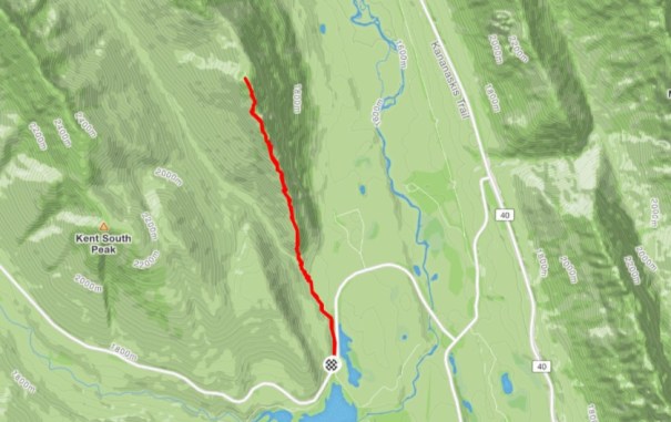
As you can see, the route is very straight-forward. Follow the spillway road, then start up the ridge.

This elevation profile makes it look like the true summit is lower than the false summit. It sure didn’t feel that way, nor does it look it when viewing the ridge from the highway. Tech sometimes does glitch. I wish I had taken separate altitude measurements at both spots.
I love all things mountains! I live next door to the Canadian Rocky Mountains, however I travel the world to enjoy the many different mountain environments and cultures that I can. I hope you enjoy these trip reports, and that it inspires you to accomplish your own adventure goals.

Leave a comment