September 12, 2015
August 13, 2018
The first time I hiked this trail, it was a super hot and muggy September day. We had hiked a lot that summer, and my kids were just a little bit done with the whole thing. Unfortunately for them, mom was feeling great, so off we went.
If you are hiking with kids, it’s important to keep them entertained, and to give breaks when they need it, not when you want. Read on for ways that I keep my usually highly motivated kids going on this hot and sticky day.
The second time I did this hike it was to take out my friend Rob. He’s not done a lot of hiking, so I thought hard about what would be a good day for him. Rob is a bit of a wild one, so I chose Wind Ridge because it was where Pink Floyd filmed their video “Learning to Fly.” To see scenes from the video compared to real life, check out this web page.
Overview
Before the 2013 flood, this was a fairly easy trail to find. Since the flood, the lower creek crossing portion is more difficult. However, it is getting better. In the three years between hikes, the trail was already way better, and soon won’t be a problem.
Once you pick your way through the rubble from the creek, the old trail magically appears. Stay on this until it makes a sharp right turn and heads straight up a steep hill. At the top, the trail makes a dramatic switch back to the left, and then leaves the forest. From here, follow the trail up an open slope. There is a wall that needs to be scrambled up. Once above this, pick your way up and through the various rock bands until you reach the ridge. Follow ridge to the top. Return the same way.
Trail Head
From the #1 Highway, take the Dead Man’s Flats overpass and go South on the George Biggy Sr. Road, heading towards the condos at the base of the old ski hill. On the right hand side is a parking lot and day use area with outhouses.
At the far end of the parking lot, continue past the roundabout, and head south on the main trail.
Main Trail
In about 200 m, there is a major junction – a wide cut line that takes you to Skogan Pass and Pigeon Mountain. Go straight past this. Around 600 m, you come to several creek crossings with brand new bridges.

This bridge was built after the 2013 floods. Look closely – the base is a large tree that fell over from the eroding bank and spanned the creek crossing. Annette took this photo of Rob reposing.
When you get across the final creek crossing, the trail heads SSW and follows the right side of the West Wind Creek.
Do not be tempted by the trail immediately heading off to your right. From this junction, stay on the main trail for another 1.6 km (approx 2.9 km in total), until the trail starts to veer away from the creek. The Wind Ridge trail makes a sharp right hand turn, and starts to gain elevation. The trail that continues straight goes into the valley beyond.
Once on this straight and vertical trail – stay on it. For the first trip, I wasn’t sure I was on the correct trail. I went half way up, then backtracked to near the bottom to check out another trail branch. It was only when I took a second look that I saw it was blocked by some branches, and even had some arrows pointing up. Lucky for you to learn from my mistakes – but my kids were not impressed!
We had some huge dead fall on my first hike with the kids.

My daughter looks positively tiny compared to this tree.
After 1 km of climbing straight up, the trail will make a big left turn switchback.

Annette takes a load off while I dick around with my pack. This is the big left turn switchback.
The trail now heads straight for the open ridge. This is when the views begin, but you can also kiss the shade good-bye.

The first views are definitely incredible! Windtower in front, and Mount Peter Lougheed being all impressive on the horizon.
As you ascend, the trail goes from dirt and vegetation, and switches to hard-baked scree and scrabble. It is also fairly steep through this section.

Heading up the open slope. This was a bit of a slog on a hot day. Great view of the Wind Ridge above as it continues to the left horizon.

Mike and Rob chatting as they make their way up the trail.
It was about this time that my kids needed to have some fun. We are huge fans of the movie The Princess Bride. The “As You Wish” scene with Wesley / Dread Pirate Roberts falling down the steep slope never fails to give us all giggle-fits. Whenever we come to a wide open slope, the girls roll down it while we all yell “As You Wish!”

My daughter tucking into the “As You Wish” roll down the mountain.
Kids are not the only ones who need a play break. I swear it took us a good 5 minutes of various poses to finally nail this one. I dare you to do it from memory on your next hike – it’s not as easy as it looks.
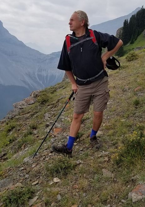
Rob doing what Rob does best.
It was now seriously hot, but we managed to find a few aspen stragglers. The kids sat down for a water and snack break in the little bit of shade we were grateful to have.

So far we were the only ones on the trail, so I had no problems taking up the whole thing.
Now the spicy bit begins. There is about a 3 or 4 m vertical rock band you get to scramble up. Above this, there is more rocky bands to work your way through, which is a delightful switch from just straight trail slog.

Looking up at the rock band. I understand you can avoid it by going right into the trees.

I will freely admit that my daughters, especially this one, are way better scramblers than me. It makes a real difference growing up in the mountains, verses coming to them late in life like I did.
Once above the fun rocky bit, it is a straight shot to the summit.

Looking back from the summit towards the ridge. While I’ve had great weather up here, the trees only growing on the leeward side tell the real story of how windy it can get up here.
The views from Wind Ridge really are stunning. I have climbed a few of the neighbouring peaks due to this view.

The Three Sisters via Stewart Creek. I climbed the Middle Sister AFTER the 2013 flood, and sorely wished I had gotten up there prior to the flood. I will let a new generation of foot soldiers flatten that trail before I try it again.

Great view looking across at Pigeon Mountain on the left horizon. Skogan Pass is the cut line heading up the middle. Centennial Ridge is on the right.
I realize this trail is called Wind Ridge, but I have to say, both times up here have been decidedly un-windy. I am NOT complaining – just pleasantly surprised. Unlike Wind Tower which blows your socks off, I will take a relaxing sit at the summit of Wind Ridge any day.
Time to Summit 2 hours, and 45 minutes. Distance is 6.88 km. Elevation gain is 802 m.
Wind Ridge Return
We returned the way we came. Both times, we were the first ones up, and had the summit all to ourselves. Both times we met several groups making their way up as we descended. This is a very popular trail, even mid-week, but it’s easy to avoid the crowds if you get on it early enough.
It looks like there is an option to head left off the main ridge trail, and go down through the trees on the highway side. As I like the amazing mountain views, I chose to remain on the main trail.
Once back at the creek, we stopped for our ritual foot soak. I just love to clean up at the end of a long sweaty hike, and it makes the drive home so much more enjoyable.

The old bridge that was wiped out in the 2013 floods is now high and dry on the far bank.
Wind Ridge is a great trail, and I highly recommend it. It’s a good distance, and some quality elevation. The rock wall adds just enough spice to keep it interesting.
If you found this post useful, please do me a huge favour and click the Like button below. Or you can go to my facebook page Al’s Adventurers and like my page.
Alisen
Totals – Tracked on Strava
Date: August 13, 2018 (I’m not posting data for 1st hike as we back-tracked)
Group: Three (Alisen, and 2 daughters) / Four (Alisen, Mike, Annette and Rob)
Distance: 16.76 km
Elevation: 802 m (2,647′)
Time: 5 hours 30 minutes (including a 25 minute lunch)
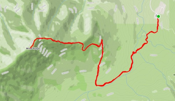
You can see where the trail turns right as it moves away from the creek. A delightful ridge walk, with amazing views. Save it for a clear day to make the most out of it.
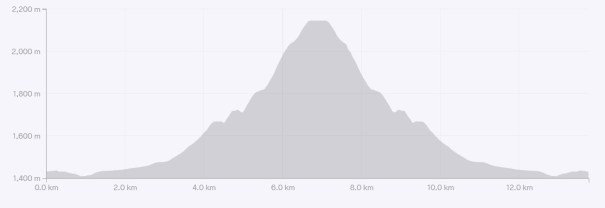
I love a good looking elevation profile. The first steep bit is the 1 km from the creek bed to the first switchback. The second steep bit is that open slope with rock and rubble.
I love all things mountains! I live next door to the Canadian Rocky Mountains, however I travel the world to enjoy the many different mountain environments and cultures that I can. I hope you enjoy these trip reports, and that it inspires you to accomplish your own adventure goals.

Leave a comment