January 3, 2020
I started off 2020 with an great backcountry ski to Gypsum Ridge, which is part of the greater Mt. Invincible. The Gypsum Ridge area is new to me, but it was just what I was after. The avalanche risk is pretty high right now, so it’s important to pick conservative areas that minimize the risk of exposure.
It was also a great choice because of the mellow ascent. The trail we chose is along the abandoned gypsum mine, which means there is a lovely, low angle road almost to the ridge top. I caught the Dreaded Lurgy (influenza) over Christmas, and I’ve been flat out for almost two weeks feeling the worst I’ve felt in years. The easy approach and mellow ascent made this ski possible.
Gear
I’m in full bc mode, with my dps skis, and Scarpa F1 boots. This will be my last tour on these boots as I got a new pair for Christmas. As soon as I get them fitted, the F1’s will be donated to my daughter.
Overview
The Gypsum Mine area offers lots of options. Climb only as high as you want. You can do laps in the trees on the lower slopes. Or you can head for the summit and snag a steep line through the trees. Despite coughing up a lung, once I got out here I couldn’t resist the summit and steep descent.
Trail Head
There are two options. ONE: Part at the Peninsula parking lot around the 1 km mark from the start of the Smith Dorain Trail. From here, ski down the closed road next to Lower Kananaskis Lake to the start of the ascent. TWO: drive up the Smith Dorian Trail to the four KM mark. There is a pole on the left marking the spot. From here, ski down the slope to connect with the start of the ascent. There is a picnic table (well buried under snow) at around .4 km that marks a good spot to put on your skins.

The confluence of the trails. Straight ahead leads back to Peninsula parking lot (skiers are going back to Peninsula). On the left is a giant mound – that’s the buried picnic table, and the route back to the 4 KM parking option. On the right, across the creek, is the start of the ascent to Gypsum Ridge.
We did Option Two, which is described in Chic Scott’s “Ski Trails in the Canadian Rockies” 5th Edition guide book. Trip reports are a great resource, but I highly recommend purchasing the professionally published guide books.
Main Trail
From the picnic table, ski across the creek and head to your left. There you will see the start of the trail. This is a fairly wide trail, which was once the mining road. Follow this low angle trail as it winds around to the south, and parallels Lower Kananaskis Lake.
The trail is very uneventful, as you are skiing through tall trees on both sides.

We were the first ones out today, so got the pleasure of clearing the track. The trees are tight, with some blow down. Even though the sun was up, we weren’t getting any solar radiation.
At about 1.4 km, the trail makes a big right hand turn to continue the gradual ascent. Prior to this point, there was a cut off through the trees. This will shorten your trip with some fast elevation gain, but we chose the flu-friendly mellow route.

This is immediately after the big bend back to the right. The only difference in scenery is it’s a bit wider. Yawn… It’s possible to cut the corner a bit – look for a decidedly direct up-track through the trees.
From here, the trail continues in the same direction for another 2 km or so, gradual gaining elevation. The fun begins once you pass the first major avalanche slope. We crossed this one at a time.

This avalanche path is very wide for the area, and is split in two. On the return, some skiers elected to ski down the up track, while others took various gullies down to the base.
Once you ski past this avalanche slope, you will see many ski tracks coming down on your left to rejoin the trail. These are the lower slopes, well treed and with good snow. This is an excellent spot for yo-yo tree skiing, with little avalanche danger.
There are great views to be had looking across the valley.

The ridge in front is Mount Kent. Poking up behind is Mount Lawson.
We kept skiing until the 3.5 km mark, and then opted to take a shortcut through the trees to the bench above. This trail was steep and unconsolidated. Two of our group had grippy enough skins, but the other two struggled.

My daughter Kayla smiling like the Cheshire Cat while her twin sister Mackenzie struggles up the slope behind her. Skins can make or break your day.
My advice – if you don’t like the shortcut, make your own. There is no right or wrong way up there. Pick a line, and off you go. Or simply keep going on the main trail, as you’ll end up at the exact same spot.

Emerging from the trees after the short cut. We are now onto the upper bench.

Had we not taken the shortcut, we would have come up this mellow slope. All options are good ones – just depends on how much time you have.
From here, you have a choice. Take off your skins and pick any number of skis runs back to the lower bench for some excellent yo-yo skiing.
Or, continue up to the ridge, which is what we did. From the upper bench, we headed straight up the ridge, and were decidedly off the mine road as we gained quite a bit of elevation over the next 500 m as we made our way up up through the tight trees.

From the same spot, looking the other way. The mellow angled approach to the ridge is straight ahead. To the right is the direct approach we took. If you want to ski these slopes, the length of the entire ridge is open for you.
The trip to the ridge was again fully treed. Once at the top of the ridge, we decided to go the extra distance and try for some views. Despite the wind and cold temps, the view was worth it.

There was significant cornice build-up on the leeward (left) side of the slope, so we stayed well back on the windward side.
I nearly freeze to death on the ridge, but the view over Kananaskis Lakes and its streams was gorgeous.
Gypsum Ridge Descent
From the summit ridge, we backtracked into the trees. We took off our skins, added helmets, and layered up as it was a very cold day. We found a line heading directly north off the ridge. This was a good 45 degrees, but in fairly tight trees. While most of the slope was getting tracked out, we were lucky to have fresh pow all the way down.

We were in and out of tight trees the whole way down. Lots of great turns in fresh, untracked powder made the trip all the more glorious. We had to zig-zag to find the next line, avoid getting caught in thick clumps of trees, and looking out for hazards like unexpected drop offs.
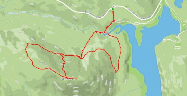
You can see from the map (below), our descent path did not take a straight line. There was quite a bit of zig-zagging to search for the next opening in the trees, and avoid the odd cliffy drop-off. I have to give it to my husband Mike – he made a left turn right above the lower bench up-track that saved us a nasty drop.
Once back on the lower bench, we went down on the up-track for about 500 m. There are several gullies that will drastically reduce your haul back time and mileage. We chose a drainage that still had some descent snow on it. You’ll have to chose your own line based on conditions and comfort level. If it doesn’t look good, then simply continue back on the up track.
The drainage popped us out just west of the picnic table at the start of the ski. Here we stopped and skinned up once again.

This is the route back to the Smith Dorian Trail at the 4 KM mark. The picnic table is just to the right, outside the photo.
I was dreading skinning up again to reach the car, but I need not have worried. There were two guys ahead of us going back to the Peninsula. They also had to skin up, despite it being relatively flat. In the end, we were packed up and driving by the time the other guys got back to their car.
Thanks for joining me in exploring Gypsum Ridge. If you found this post useful, please hit the Like button below. Or you can go to my facebook page Al’s Adventurers and join my group.
Alisen
Totals – Tracked on Strava
Date: January 3, 2020
Group: Four (Alisen, Mike, and two daughters)
Distance: 8.35 km (this will change depending on your route and descent)
Elevation: 456 m (1,504′)
Time: 4 hours (including lunch and skin swaps)
The approach was laid back and mellow, while the descent was a (more or less) direct line. We parked 4 km from the start of the Smith Dorian.
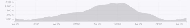
The elevation profile shows how relaxed a trip this can be. It also shows how direct it can be on the way home.
I love all things mountains! I live next door to the Canadian Rocky Mountains, however I travel the world to enjoy the many different mountain environments and cultures that I can. I hope you enjoy these trip reports, and that it inspires you to accomplish your own adventure goals.

Great post😀
Wow, just look at your beautiful snow photos! Having lived in Ireland for nearly two decades I miss the snow and winter sports so much! Thanks for sharing and have a good day 😀 Aiva
Ireland!!! I went there when I was 21 and I almost did not come home. I LOVED it there! Enjoy.
Sounds like there’s an interesting story! 😊
I really like your blog. A pleasure to come stroll on your pages. A great discovery and a very interesting blog. Fascinating and beautiful. I come back to visit you. Do not hesitate to visit my universe. See you soon 🙂
Thank you for the kind words. I have just looked at your blog. Lovely photos! I will explore more. Happy trails!
Great advice, I’m sure, but I’ll just stick to looking at your wonderful photographs and wishing I had the nerve to strap on skis again and take off. Too dodgy on my feet now and too liable to break a leg, so I’m an apres-skier now, only go for the Schnapps and strudl.
Ooohhh! I love a good strudl. My husband’s father Austrian, so I am all over your apres-ski selection. It warms my heart to know that you did once ski, and I hope you have some fond memories of snow and boards.
OMG – there are things I miss leaving the snow behind but I’m now a tropical native. I just visit mountain snow every once in a while. Great pix…
After just coming back in from yet another -30 Celsius day of skiing, I can totally appreciate why you are now a tropical native. I love skiing, but this cold is getting to me. I do hope you come for a yearly hit of snow, just as us Canucks hit some place tropical each winter.