June 2, 2020
I started cycling three years ago after I trashed my left knee backcountry skiing down a canyon. Long story. When I asked for a good exercise to help my knee heal and get stronger, the answer was cycling.
I joined the Highwood Cycle Club in Okotoks and stared riding with the women’s group. It was pretty embarrassing to start, because most of the women were either actively training for an Ironman event or were former triathletes. However, they are a welcoming group, and are happy to help a new person learn the ropes.
I’ve gone from actively ignoring my bike, to actually looking forward to riding. This means I’m now on the hunt for new routes. I’ve always wanted to cycle the 1A Highway – known as the Bow Valley Parkway – from Banff. Luckily for me, this year the road was closed to car traffic due to road paving and Covid-19. This was a rare opportunity, so we packed up the whole family and off we went.
Gear
I am riding a Trek 1000 road bike, but the kids only have “town” hybrid-type bikes. Mike was riding his mountain bike with knobby tires and panniers to carry our lunch. While the vast majority (99%) of the riders were on road bikes, we did the full 62 km no problem on our non-aerodynamic bikes.
Where to Park
We parked at the Fenlands Recreation Centre on the western edge of Banff. It is closed now for Covid-19, but it has a large parking lot so can probably accommodate extra parking even when open.
There was some parking at the start of the Bow Valley Parkway gate, but I’m not sure if this is always an option when the road is open.
Main Trail
From Banff, take Vermillion Lakes Road westbound. This road parallels the #1 Trans Canada Highway. This is a scenic view of Vermillion Lakes, and the surrounding mountains. Keep an eye out for canoes and kayaks that paddle up from Banff. There are lots of pull-outs here for cars, so be careful of Door Prizes as tourists have their eyes on the scenery.

It’s worth it to stop and admire the view. This is a classic view of Sulfur Mountain (right) and Mount Rundle (snow covered on the left). The Town of Banff is snuggled between these two mountains.
Where Vermillion Lakes Road ends, it is the start of the Vermillion bike trail.

This is the start of the bike trail. It’s a lovely up and down through the forest.

At one point you are riding parallel to the TransCanada Highway, but ignore the sound of the cars and focus on those lovely mountains ahead.
Follow the bike trail all the way to the end, passing through two separate gates. These are to keep animals, especially Elk, out of the Banff town site. Elk are HUGE and can be aggressive. Ensure you close the gates behind you.

This is the second of two gates. Ahead, you can see the path turning to the right and a wooden fence. This is the connector road to the 1A, or the Bow Valley Parkway. Keep an eye out for cars when crossing.
At the end of the trail, you come to the 1A Bow Valley connector road. Turn left, keeping an eye out for car traffic.
Follow the connector and it takes you to the start of the historic 1A Highway “Bow Valley Parkway” gate. This was the original narrow road through Banff National Park, before the TransCanada Highway was built. It is now a scenic drive, with many pull outs to admire the views of the surrounding mountains.

Welcome to the historic Bow Valley Parkway!
Below are some photos of the scenery on the way west towards Castle Junction, which is both a highway interchange, and the base of Castle Mountain.

This is the lower flanks of Mount Edith. The approach and the view of his popular and massive mountain are on the other side.

Mount Ishbel (far left and white) and Cockscomb Mountain make up this jagged range.

Only in Banff would the road go around the trees. Banff is Canada’s first National Park, and is here to protect the flora and fauna that live here. All humans are guests only here. Tread lightly and respect the nature.

This is called Moose Meadows. It’s a low, grassy wetland ideal for moose. I didn’t see one today, but that’s okay because I’ve had my fill of moose. They can be very aggressive so keep your distance.

Riding up to the Johnson’s Canyon round-about. In the distance is Castle Mountain. We are riding to the base of it at Castle Junction. Climbers scale the outside (left) of this mountain, while hikers head for Rockbound Lake, which is located inside the horseshoe-shaped massif.
Castle Junction
This is a rest stop at the intersection of Highway 1, the Bow Valley Parkway (1A) and Highway 93 (that goes to Inveremere). There is a general store, chalets, the Castle campground, and the trail head to either climb Castle Mountain, or hike into Rockbound Lake.
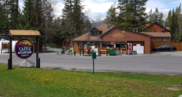
When my kids were little, their grandparents would always stop here on the way to Invermere and buy them a little treat.
This is our end point. We turned around here, and then biked back to the Castle campground where we ate our lunch. However, the fun need not end! The Bow Valley Parkway continues all the way to Lake Louise.
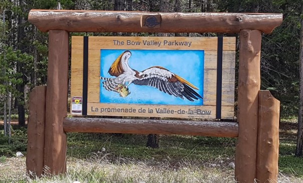
This sign welcomes people at Castle Junction to the Bow Valley Parkway. You can either head west to Lake Louise, or east towards Banff.

We ate our lunch at the nearby Castle Campground, which is currently closed.
Johnson’s Canyon
On the way back, we stopped at Johnson’s Canyon. I wish I was wearing normal shoes, because we could have hiked up the trail and had the falls all to ourselves. Instead, we got a chai latte and enjoyed the river.

Johnson’s Canyon is a huge tourist attraction. It’s so busy, we now only go in the winter. It was a real treat to be here when it was so quiet.
The return bike is just as enjoyable for a couple of reasons. First, your mountain view changes.

This beast is called Pilot Mountain. You can see it when riding down Vermillion Trail, but this is the more impressive view.

Bow Valley Parkway parallels the Bow River. Right now it is swollen from the mountain run-off. When this is over, the waters are icy blue and clear.
Second, the road is different! The highway splits in two for several kilometres. Heading west is the ‘high’ road, which takes you up a pretty good hill. The way east takes the ‘low’ road and skips this hill.

The way back is a much gentler stroll through shady forest.
Finally, keep your eye out for wildlife. We saw one coyote, several deer, and this Rocky Mountain Sheep that was so well camouflaged that six other cyclists zoomed past without noticing him.

A young male Rocky Mountain Sheep. They are usually seen in packs, so perhaps he got separated, or his family was further up the mountain. The sheep LOVE to lick salt off the road, so care must be taken when driving. It’s not unheard of for these sheep to block traffic for KMs as people try to slowly go around them.
Once we were back in Banff, we loaded up the bikes, and then walked around town. It was delightful to be in Banff without a million tourists. This was the Banff of my childhood and I’m glad I could enjoy it.
If you found this post useful, please do me a huge favour and click the Star button to “Like” it. You can also follow my blog, or head on over to Facebook to join my page Al’s Adventurers.
Alisen
Totals – Tracked on Strava
Date: June 2, 2020
Group: Four (Alisen, Mike, Kayla and Mackenzie)
Distance: 62 km
Elevation: 464 m (1,530′)
Time: 4 hours (a very leisurely pace)

The road splits at one point. It is quite steep heading west at this point, but is very mellow for the return trip.

There is definitely some elevation gain. The big peak is the where the road splits off (mentioned above) but you can see there is no major ascent on the return trip.
I love all things mountains! I live next door to the Canadian Rocky Mountains, however I travel the world to enjoy the many different mountain environments and cultures that I can. I hope you enjoy these trip reports, and that it inspires you to accomplish your own adventure goals.

We just did this today. Fantastic!
Yeah! This is such a fun ride. So glad you got to enjoy it.
Yesterday we did the legacy trail from Canmore to Lake Minnewanka and back. It looks from your site as we have done a lot of the same kinds of hikes too 🙂
We’re heading up there in about 7 weeks, Alisen. We won’t be cycling (hiking instead), but it was great to see your photos. 🙂 Thanks!
Yes, that’s right. Good think you’re coming a bit later because we have a LOT of snow still, especially in the areas you are heading. It was an amazing snow year.
We tried to time it for the peak of summer! Snow is good though. Can’t wait.