March 26, 2021
In my quest for good shoulder season hikes that are protected from the howling west winds, I found Cox Hill. This is quite a popular hike, but I have to admit this was my first time in the Sibbald area. It was all new to me. I enjoyed the challenge of figuring out the highway to get there, and then seeing familiar landmarks, like Moose Mountain, from a completely different angle.
I hiked Cox Hill after a pretty big snowfall. We broke trail the whole way, but it was on a supportive base so the going wasn’t too bad. In the winter, this is a hiking only trail, but in the summer it’s wide open for hikers, mountain biking and horses. With all these users on the trail, be sure to know your passing etiquette, and share the trail.
Gear
Hiking boots, poles and regular day pack kit.
In the winter, add in gators and microspikes. Be avalanche aware. The final slope to the ridge is exposed with no trees.
Overview
From the trailhead, take the left trail to cross Jumpingpound Creek at the bridge. At the T intersection, turn Right. Stay on the trail until you reach the ridge, which marks Cox Hill NE Summit. To nab the true summit, turn right (southwest) and walk to the end. Return the way you came.

Parking and Trail Head
From Highway 68, take the Powderface Trail.
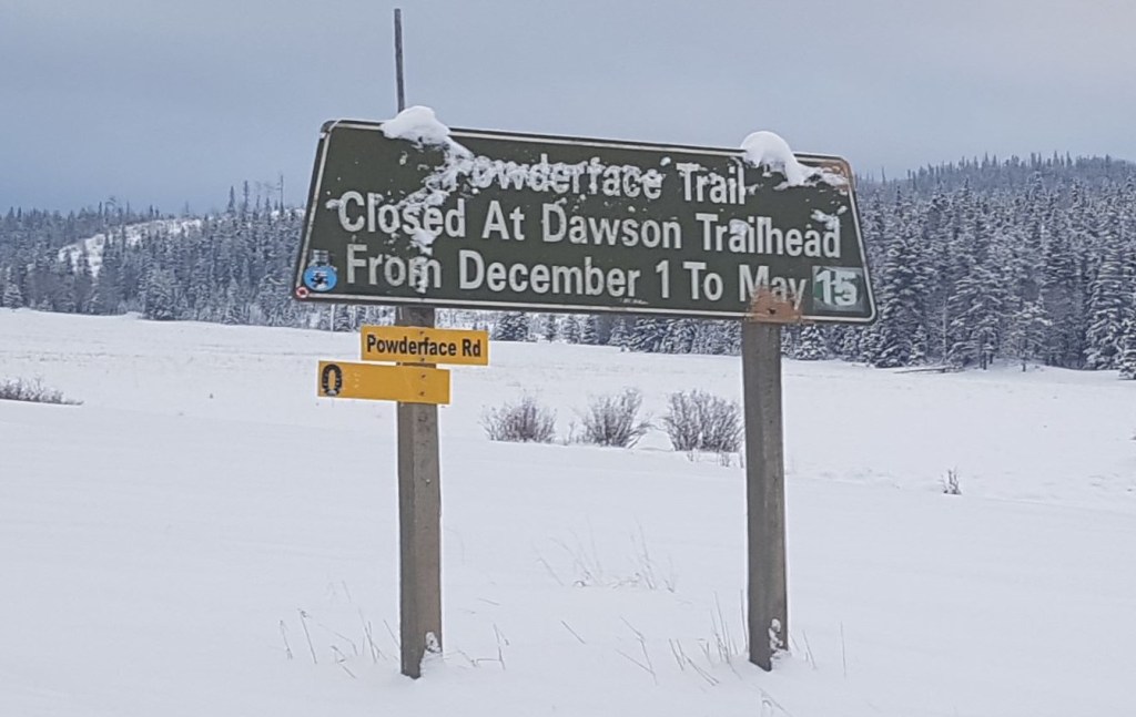
Prior to the winter gate is the Dawson Equestrian Campground. I parked here in the winter. In the summer, double-check that it is okay for non-equestrian vehicles to park here. At the very least, be aware that horse trailers take a lot of room to maneuver and turn around, so don’t take up the whole lot with cars.

At the east end of the parking lot is the trailhead.

Take the trail on the left, which leads to a bridge for humans and bikes. The lower, right hand trail is for horses to cross Jumpingpound Creek.
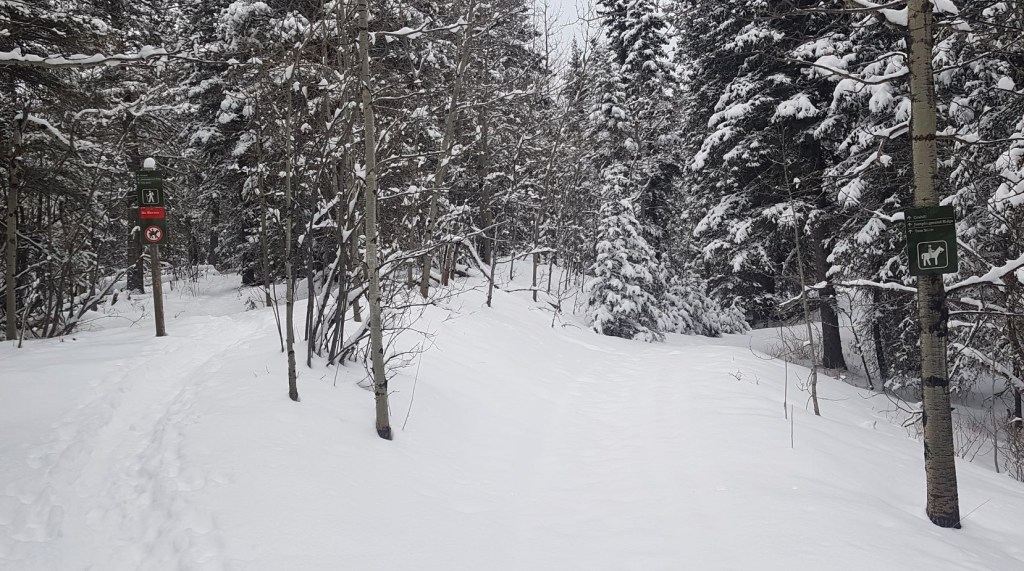

After a short walk, turn right at the T intersection.
Main Trail
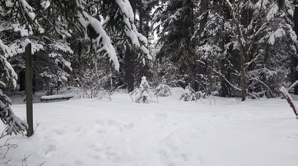
Once on this main trail, follow it to the Cox Hill ridge. Most of the trail is in the trees.

There is a good lookout prior to the turnoff to Shell Hill.

When we arrived at the open slope below the ridge, I took stock before heading up. Storm snow is unpredictable, so we took basic precautions. We spread out, so only one person was on the slope at a time. We were also careful to not ‘stack’ the hikers in our group as we went up the switchbacks. We would only stop and wait on the sides, near mature trees.

Right below the ridge, we took a minute to bundle up. The wind would be howling as soon as we crested the ridge, so it made sense to add layers here in the comfort of the leeward side.
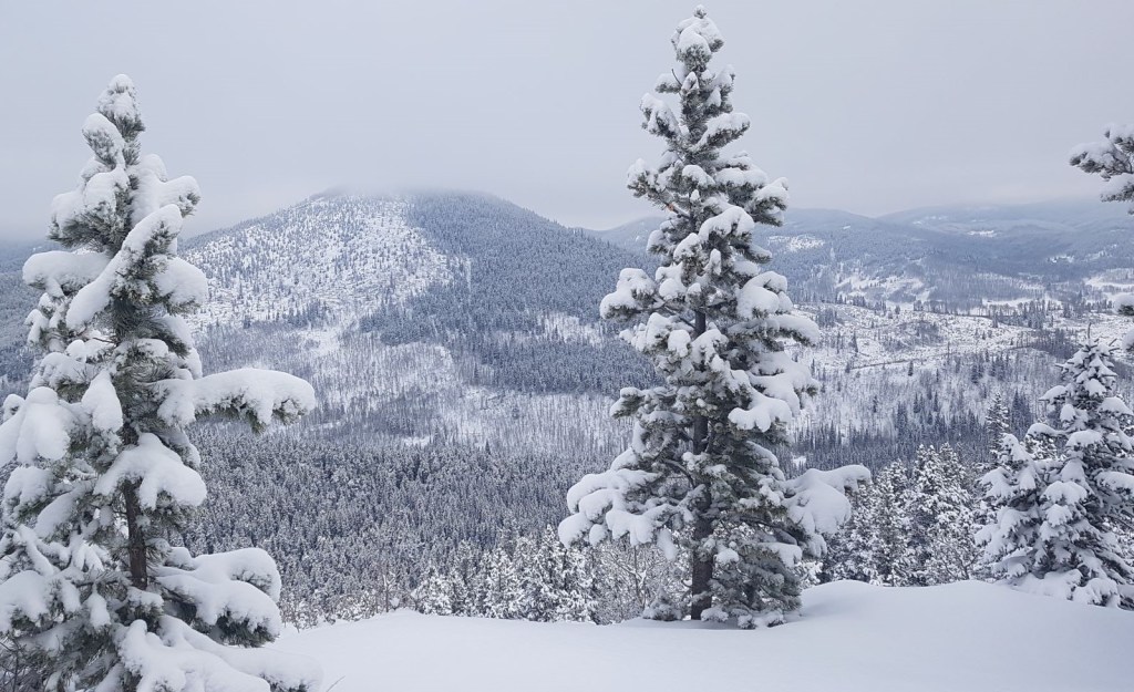
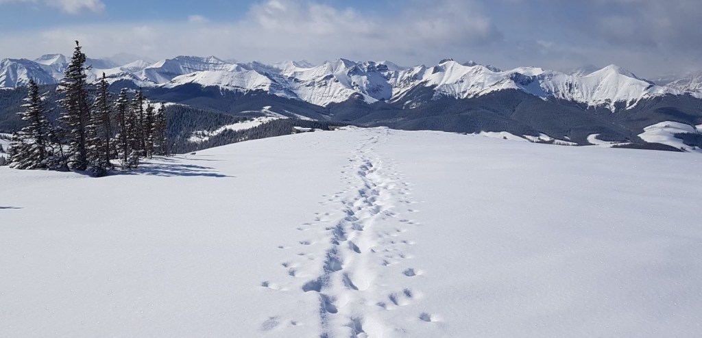
Once on the ridge – wow! The views are spectacular.
From the Cox Hill Ridge, we turned right (south west), and continued along the ridge for another 1 km to the high point of Cox Hill.

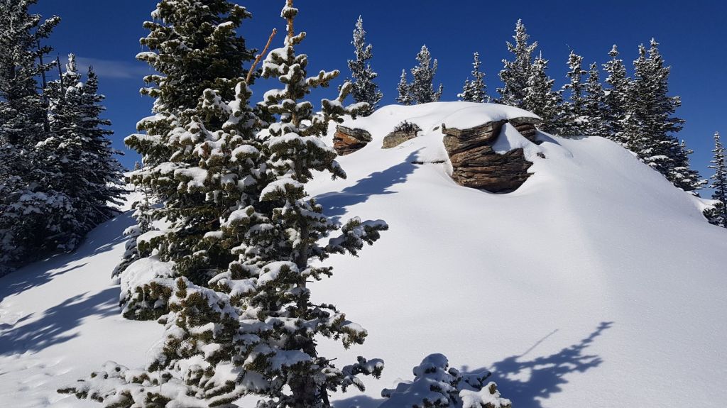
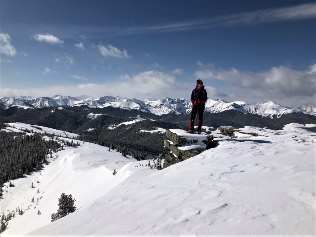
Like all ridges, this is where we found the interesting rock formations. I would have liked to see it with less snow, but oh well.
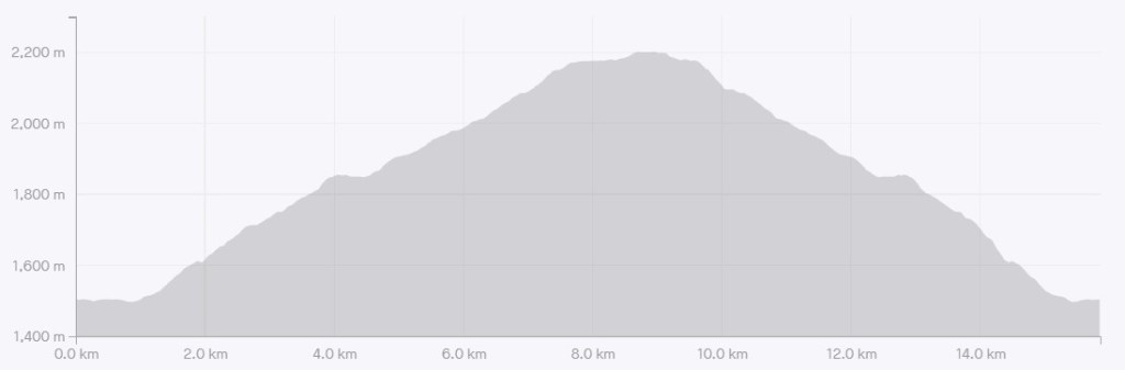
The official distance to the summit of Cox Hill is 9 km, but we recorded 8.3 km. Elevation gain is 872 m. Time to summit was 3 hours and 45 minutes in deep, fresh snow.
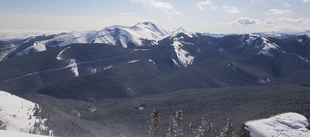
The view on the other side is Moose Mountain. I’m so used to seeing Moose from the south side. It’s amazing how small the area between highways 66 and 68 really is.
Cox Hill Return
The summit of Cox Hill need not be your stopping point. Those with multiple vehicles could keep going and connect with Jumpingpound Ridge trail. There are quite a few trails that interconnect, so you are only limited by your imagination and legs.
For the rest of us mere mortals, we did a There and Back trip, and returned the way we came.

When you are almost back to the parking lot, remember to turn left at the T intersection. Shortly after turning left, there is another Y for the bridge crossing. Humans go right, and horses go left.

Cox Hill was my first foray into the Sibbald area, but I don’t think it will be my last. An enjoyable shoulder season hike with lovely views of new (to me!) mountains.
If you found this post useful, please do me a huge favour and click the Star button to “Like” it. You can also follow my blog, follow me on Instagram, or join my FaceBook page Al’s Adventurers.
Alisen
Totals – Tracked on Strava
Date: March 26, 2021
Group: Three (Alisen, Sonya and Margaret)
Distance: 15.86 km
Elevation: 872 m (2,878′)
Time: 6 hours (includes lunch & breaks)

I love all things mountains! I live next door to the Canadian Rocky Mountains, however I travel the world to enjoy the many different mountain environments and cultures that I can. I hope you enjoy these trip reports, and that it inspires you to accomplish your own adventure goals.

Love the photos, especially the Cox Hill Money Shot 🙂
🙂 Glad you liked it.
Really beautiful photographs. The views from Cox Hill are amazing!
Yes, I was pleasantly surprised. Did not expect those views.
Blessings.
Goodness those really are spectacular views from the top of Cox Hill! You were sooo lucky with the blue bird weather too!
Yes, excellent point! The sky really cooperated. It would have been a totally different experience if it stayed clouded in with no view.
There’s always something so magical about going for a hike after a fresh snowfall. And it’s always fun to explore a new area. The views from the top of the ridge look beautiful. I’m glad to see that this trail has an actual trailhead!!
LOL! You are SO funny! I hiked up Grotto Mountain yesterday and was taking photos of the wood pile below the ACC Clubhouse – the allowed parking for that trail – I was thinking of YOU! 🙂
Haha, thanks! I do love taking pictures of wood piles! Grotto Mountain sounds familiar so I looked it up on Wikipedia. It’s home to the Rat’s Nest Cave. We went on a cave tour here a few years ago and had a blast. The mountain itself looks pretty spectacular too. Can’t wait to read your post about it.
The Rat’s Nest Cave is pretty cool. I’ve done Cody Caves near Nelson. That one is pretty unknown. We had the tour to ourselves, and got to explore to the very end. Highly recommended.
I’ll have to visit Cody Caves next time I’m out west. The description for the adventure cave tour on their website sounds like quite there experience. That’s amazing that you had the tour all to yourselves and were able to more fully explore the cave.
Being as my last name is Cox, climbing Cox Hill might be fun!!
It’s always fun to hike a namesake. Last year I did Mount Roberta for the sole reason that it’s my mother-in-laws name 🙂
Lovely place to hike around. Amazing views to see from the hill.
I was pleasantly surprised by the views. Now I have to go visit all those new mountains 🙂
This looked like a gorgeous hike!
It is pretty nice. Probably even better in the summer.
Hi
Thank you so much for sharing your great post.
Thank you. I hope all is well in Nepal.
A beautiful hike it looks
Thanks for sharing