September 13, 2021
I was lucky enough to join the Alpine Club of Canada’s Rocky Mountain Section for a multiday hiking trip into Tonquin Valley in mid-September. The trip was lead by the amazing, energetic, knowledgeable and oh so patient Ivan. I swear he’s hiked and skied every square inch of Tonquin Valley, and knows it very well. The remaining seven of us were all Tonquin newbies, ready to soak up Ivan’s vast stores of knowledge and folklore.

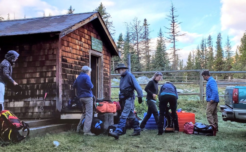
This was a five day trip. One day each to hike in and out, plus three day trips. We stayed at Tonquin Valley Adventures, which is located on the shores of Amethyst Lake, right in the middle. I believe this was originally a Brewsters cabin, so it has a choice location. The lodge is located equal distance to all the hikes in the area.
Tonquin Valley Adventures is a horse outfitter. This meant we could hike in with only our day packs, while Gilbert and his horses brought in our food and extra clothing. We were self-catered, and the food was excellent with plenty of it. We stayed in little cabins around the main cooking / eating / lounging lodge, which was heated by wood stove. The cabins have their own propane heater, with heavy down duvets. The weather was cold and wet, so we sure did appreciate the warmth.
Gear
Boots, poles, and gators, plus your regular hiking pack kit.
Tonquin Valley is a wet place. Ivan told us it gets 20% more rain than Jasper and area. We were there in September, but I can see this place being wet all year round. If you don’t normally use poles, I would suggest them here. We used our poles to vault over massive mud pits as we rock hopped endlessly, plus there is boggy marshes to get over. Gators were a must to keep our pants somewhat clean, and somewhat dry.
Binoculars and a good zoom camera to watch the Caribou is also an option. We found the Caribou right on Amethyst Lake, and in a meadow closer to the warden’s cabin. For obvious reasons, we didn’t get close. These animals are endangered and should be left alone.
Overview – Day One: Edith Cavell Parking Lot to Tonquin Valley
After dropping our food and extra clothing with Gilbert and his horses, we hiked along the Astoria River Trail for just over 8 km. At the junction to Wates-Gibson Hut, we kept right. Shortly after, we crossed a massive and active rock garden. Rock fall is common, so we did not linger. Once past this, we started up the switchbacks beside the rock fall. This was the majority of the elevation gain. We continued west on the main trail. The views increased dramatically, but the trail decreased in equal proportion as we entered the Tonquin Valley. At the 18 km mark, we went right at the T intersection. From here we lost some elevation on the last 2 km to the lodge, crossing a marshy area and a long boardwalk.
Parking and Trail Head
We parked at the Astoria River Trail Head, which is on the Mount Edith Cavell Road (not to be confused with Mount Edith above Banff) near Jasper. This is also a popular stopping point for tourists to view Cavell Lake, so be prepared for cars coming and going frequently.

The trail head is at the start of the parking lot, and winds down and around to the right before it heads back towards Cavell Lake.

The Cavell Lake bridge is just a few hundred meters away from the parking lot, with an absolutely stunning view of Mount Edith Cavell.

Main Trail
Once past Cavell Lake, we continued on the Astoria River trail that would take us right into Tonquin Valley.
This part of the trail is in great shape. It’s wide enough for two people to walk and talk, and it’s blessedly dry. Looming above on the left is Mount Edith Cavell herself.

At about 4 km, we came to the trail on the other side of Mt. Edith Cavell, which I think is called Trail’s End. It’s the climbers descent route off the mountain, or it’s a There and Back hike to view the lakes nestled in the mountain.

The trail bobbed up and down a bit. At around 4.5 km, we crossed Verdant Creek, with glorious views up and down the valley.

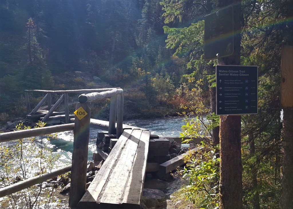
In another 300 m, we crossed Astoria River on a narrow foot bridge. The Astoria campground is 7 km from the trailhead, and is the first in a series of campgrounds.

At the 8.5 km mark, we passed the junction for The Alpine Club of Canada’s Wates-Gibson Hut. We would visit the hut in two days times, using a different route.
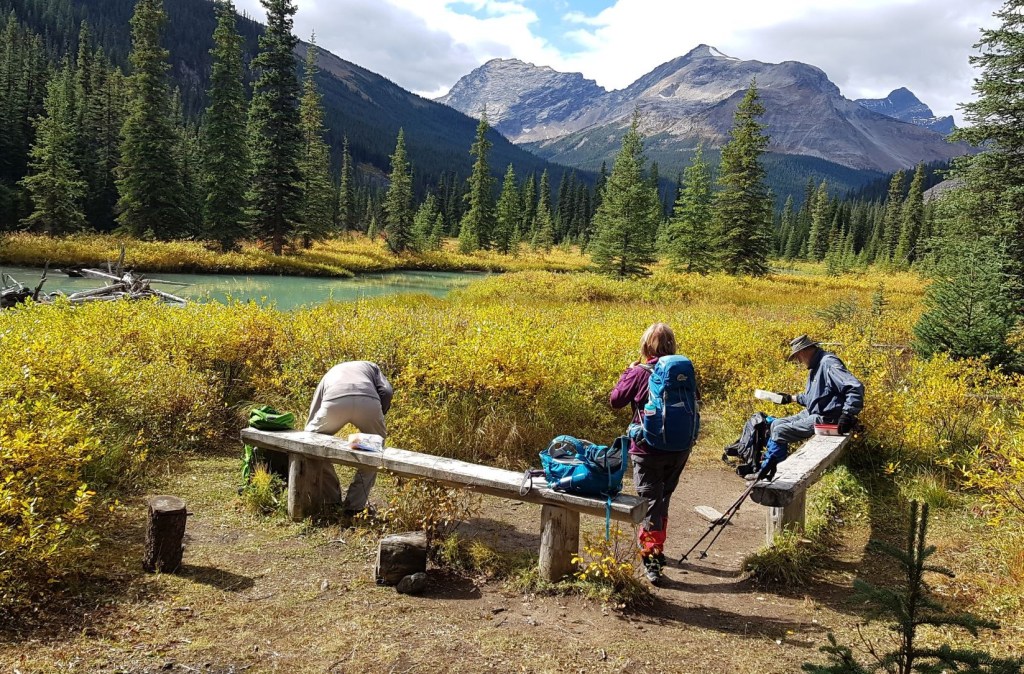
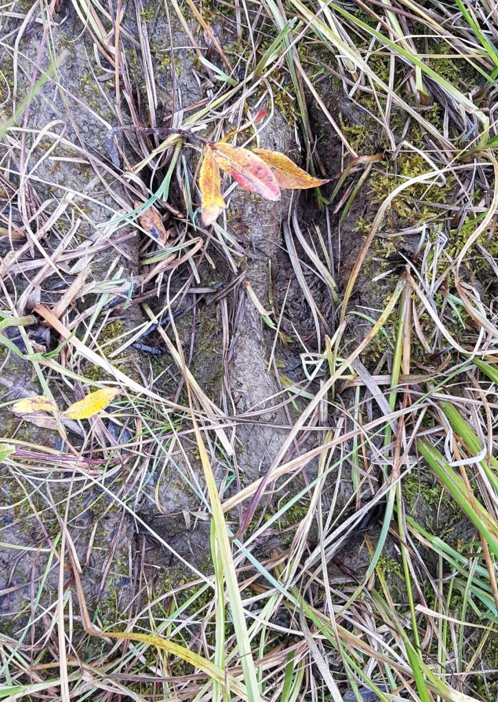
We hiked for another 150 m or so, and found a lovely spot for lunch. There were several benches to sit on, plus an open air throne outhouse in the trees, opposite the river. I found some Caribou footprints along the shore of Astoria River here, so keep your eyes open for a sighting.
At about the 10 km mark, we hit the massive rock slide. This rock garden is active, so we kept the pace up and didn’t linger.
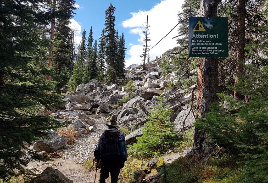
We waited at the start of the rock garden for Gilbert and his pack horses to pass us, just in case recent rock fall meant the horses couldn’t get through. The last horse is a major flirt! He always stops at a group of women and waits patiently to be petted and admired.

Once past the rock slide, we gained all the elevation for the day in a series of sweeping switchbacks that only the National Parks can build. We gained the elevation with nary anyone noticing. Along the way, we found a grand photo op that looks back towards Mt. Edith Cavell.

Once at the top of the switchbacks, we stayed at this elevation for a long traverse. We hiked under Oldhorn Mountain, the lower portion being the rock slide.

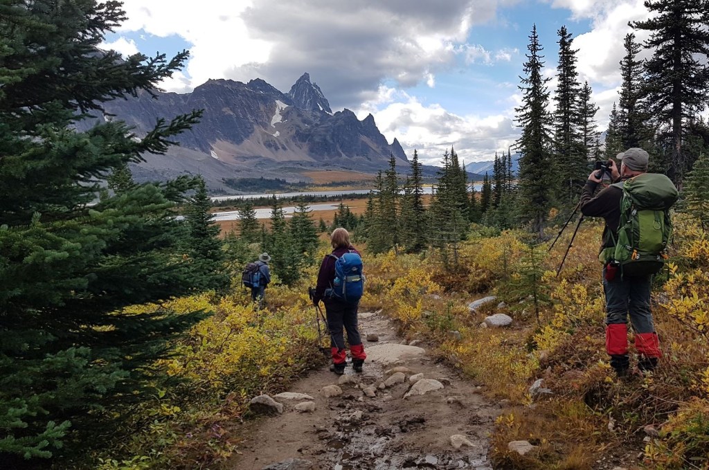
We stopped for a tea break in the meadow on the opposite side of Switchback Campground, which is13.8 km from the trail head. This is where hiking with someone like Ivan is invaluable. From our position, we had a glorious view of the Eremite Range. We wouldn’t be able to see these mountains until our return, so it was great to soak up their beauty while we could.

As this was a new area for me, I asked to read Ivan’s large paper map. I like to follow along and name the mountains as we go, as this is the fastest way to gain situational awareness. Ivan pointed out a peak, and asked me to find it on the map. I thought I figured it out, but then realized I was off track. It turned out to be Outpost Peak, which is a good landmark to have. The Wates-Gibson Hut sits below this, and it’s directly across from the start of the impossibly beautiful Ramparts.
While you might be tempted to just boot it along the trail, especially because it is close to 20 km, I highly recommend that you take your time. The views really are incredible.
Once afternoon tea was done, we continued on the quickly deteriorating trail. Ivan regaled us with various trail building attempts over the years to deal with the wet trails, but nothing seemed to be working. We started rock hopping and pole vaulting from dry spot to dry spot. This would be our main mode of travel for the next several days, and it really slowed down our progress. What would normally take an hour seemed to drag on forever in an effort to stay somewhat clean and dry. While we were lucky to dry out in the lodge, the backpackers we chatted with along the way were wet with no way to dry out.
At the 18 km mark, we came to the T intersection. We went right towards Amethyst Lakes, while left lead towards Clitheroe Campground and the alternate way into the ACC Wates-Gibson Hut.

Shortly after the T intersection, go right at the fork, following the Hiker sign. The other trail is also strong, but it’s way more muddy and boggy.

This is a slight elevation loss as we descended into Tonquin Valley and the Lodge on the shores of Amethyst Lake.

Directly across from Amethyst Lake, we crossed a boggy area, and a long boardwalk that lead to Tonquin Adventure Lodge. We felt the boardwalk could have easily spanned the entire area, but what do I know?
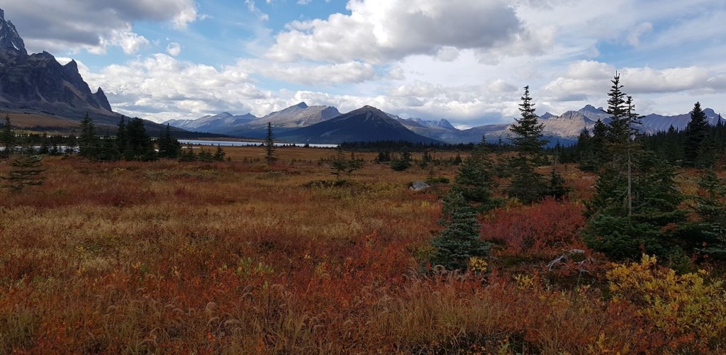
We arrived at the lodge to find Gilbert and the horses running free. The horses know where they can go, and had fun running down to the lake and back to the lodge. There used to be a larger grazing area for the horses, and Gilbert has some hilarious stories of one of his horses visiting the backpackers’ campsites. The horse would stick his head right into their tents to say hello. Sometimes, the tent fly would get stuck on his neck, and the horse would come back to the lodge all tangled up. Gilbert would untangle him and then have to go in search of a naked tent.

There is a large family of marmots living under one of the buildings. This is excessively cute, BUT it also meant we had to keep an eye on our boots and gear. Marmots will gladly steal your boots and other clothing to chew and lick the salt off. Everything stayed inside to dry.
Down by the shores of the lake, a group of Caribou were lounging.

After getting settled into our cabins, which were two bunkbeds with heavy down duvets, we headed to the main lodge for a lovely homecooked meal.
The fun doesn’t end here. Next up is Day Two of the Tonquin Valley Adventure and our summit of Mount Clitheroe. On Day Three, we hiked over to the ACC Wates-Gibson Hut. Day Four was a trip to Majestic Ridge.
If you found this post useful, please do me a huge favour and click the Star button to “Like” it. You can also follow my blog, follow me on Instagram, or join my FaceBook page Al’s Adventurers.
Alisen
Totals – Tracked on Gaia, Displayed on Strava
Date: September 13, 2021
Group: Eight (Alisen, Ivan and the Rocky Mountain Section participants)
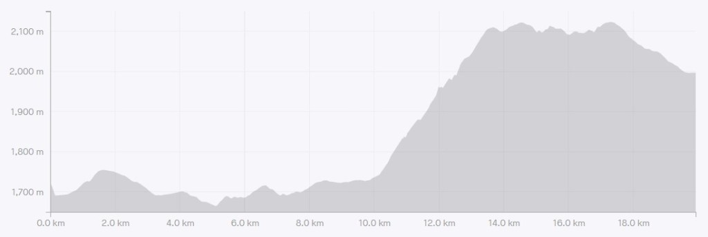
Distance: ~19 km
Elevation: 468 m (1,544′)
Time: 7 hours 30 minutes (includes lunch & breaks)
Notes on Time: this was a long and leisurely stroll in, with three solid breaks. On the return trip, I had to hustle to get to another trip. My return trip was only 5 hours, but no chitchatting or sight-seeing.

I love all things mountains! I live next door to the Canadian Rocky Mountains, however I travel the world to enjoy the many different mountain environments and cultures that I can. I hope you enjoy these trip reports, and that it inspires you to accomplish your own adventure goals.

I’ve done the other side of this hike over Maccarib Pass to get to Amethyst Lakes. I had always thought the Edith Cavell side was on a road and in the trees with no views, but your pictures and descriptions make it sound like a great trail. Maggie
Hey Maggie,
Yes, we did get some lovely views, but there was a long stretch in the trees below Mt. Edith Cavell. We were planning on going out via Maccarib Pass, but we had hiked up that way the day before towards Majestic Ridge and the trail was in terrible shape – one giant mud bog. As it turned out, the ground was frozen in the morning so we could have done it. Oh well.
Alisen
Looks like a fun time. Such beautiful scenery 🙂
Hi Ann,
Yes, I was pleasantly surprised. I had almost no beta on the area, just that I wanted to be in the Tonquin and see the Ramparts. Lovely place with fairly easy hiking.
Alisen
What a stunning start! I bet there is even more beauty to follow. Mel
Yes, I just have to get my butt in gear 🙂
This looks so beautiful, wow! I can’t wait to read about the rest of your trip. Also, I had no idea caribou could be found that far south. What a neat sighting!
Hi Diana,
Yes, caribou can live nicely this south, but they are endangered. Banff used to have a herd, but they are now gone. The last herd were all killed at the same time by an avalanche. The main issue for caribou now is the winter access roads and human created ski and snowshoe tracks. Wolves have figured out that they can follow the human made tracks in the winter, which gives them access to the caribou in the winter. Jasper has now closed down Tonquin Valley in the winter so there are not human tracks for the wolves to follow. Hopefully this helps.
Wow, interesting. I will be curious to know if the closure helps the caribou.
Now this sounds like a multi-day backcountry camping adventure that I would enjoy! That’s awesome to just hike with a day-pack, stay in a heated cabin, and eat excellent food. This hike looks particularly scenic in the fall with all those golden yellows. How awesome to see some caribou after your first day of hiking. Looking forward to reading about day two.
Oh my goodness! You would LOVE this! Yes, totally up your alley. Very easy hiking, but all the days are long. I would highly recommend it because not many people get out here. Plus, it’s reasonably priced. So many lodges like this in the National Parks are extremely expensive.
I wondered what you’d been up to. 😀 … following along with Goggle maps, I am. 😀 … glorious, glorious mountains. I can smell that alpine air from here. 🙂
Yeah… I kinda fell off the map for a while. Right after this trip, I went to Austria and Italy for just under 3 weeks. When I came back, I had some serious thinking about the Rocky Mountains and where it’s heading right now. I have an idea of what I want to write, but because I wasn’t getting on it, it blocked all my other writing. So… last night I FINALLY figured out what my block was, and how to deal with it. Hence…. why I’m JUST NOW getting back to you 🙂
I love that you follow along on google maps. I kinda keep that in the back of my mind now when I’m writing. If you can follow on google, then I’m doing alright. More to come, my friend! And hopefully soon 🙂
Alisen
Excellent, on both counts. 🙂
Makes me want to return to Jasper. Such a great place to see.We hiked around Banff in October. Thanks for sharing Anita
Hi Anita,
We had great weather in October – I hope you had a good time. Where did you get to?
Jasper and the Icefields Parkway are glorious. Definitely worth their own trip.
Alisen
We visited Banff and stayed at Kimberley for a bit and had a great time with our son in Cochrane Alberta.
Anita
One more reason to visit Canada.
Beautiful sceneries 💥
Ha ha! Yes, we have about a millions reasons to visit 🙂
Look me up if you come. I can give you all kinds of hints and tips.
Alisen
I’ll remember to do that. 🙂
I just have to make it happen soon.
Great day.
Can’t wait for the next part of this great hike. What a fantastic trip, I’m totally in awe of what you did. Even when I was younger and fitter I was never in this class. You are way up there with the real hikers, not people like me who play at it. Thanks for a brilliant read.
Wow. You just made me blush. Thank you for those kind words, my friend. Now I need to get on the rest of that trip. I’ve had a bit of writer’s block, but I found the source last night, so now I can move on and continue.
However, I am a firm believer that everyone gets to chose their own adventures, and how hard they want to go. I love it that you’re out doing your thing, and making your own adventures. You do you, and feel good about it! I’m just happy if I can inspire you to make your own dreams come true.
Enjoy, my friend, enjoy.
Alisen
Thanks, you give me so much encouragement.
Awww, thanks. That’s what I want to do – encourage YOU to do your own amazing things. And then write about them 🙂
The Ramparts look amazing!
They truly are stunning. I had heard about them for years, but didn’t really have a sense of why they were so well known. Now I know!
This picture is an art initself. Nature is so wonderful and you have such a keen eye for it. 💜
Thank you! It’s amazing how nature does all the heavy lifting – I just have to point and shoot 🙂
Indeed it is doing all the heavy lifting 🌸