August 9, 2022
This is Day 2 of 6 in the Ultimate Sawback Range Backpack in Banff National Park. To see the trip overview and daily breakdowns, click HERE.
After yesterday’s relaxing time at Larry’s Camp, Erin and I got up early, had breakfast and decamped by 8:30 am – pretty much before anyone else stirred from their tents. I was very happy for the early start, because we had a long hot day ahead of us.
Picking good backcountry partners is the most important part of any adventure. Erin and I were well matched with sleep schedules, eating schedules and food amounts, as well as hiking pace. Erin was faster on the uphill, but I’m faster descending. We both have the same mindset of getting up early and start hiking before the heat of the day totally saps all our energy.
This was the first of two long days with lots of elevation gain. The second was Day 5 when we hiked Badger Pass. Yes, this is tiring, but these two days were also the most beautiful and rewarding. Backpacking is a long, slow burn, punctuated with hits of joy as the next vista magically opens up in front of us.
I am breaking this trip report into sections. Below is the Overview, with each section following.
Day 2 Overview – Larry’s Camp to Mystic Pass, Mystic Lake and Mystic Junction
From Larry’s Camp, we hiked around the north flank of Mystic Peak, with epic views from the high point at Mystic Pass. We descended on the east side of Mystic Peak, and did a side trip to Mystic Lake. We then continued past the Mystic Valley Campground, and spent the night at Fm19 Mystic Junction campground.
Totals – Downloadable Tracks on Gaia, Displayed on Strava
Date: August 9, 2022
Group: Two (Alisen and Erin)
Distance: ~17 km (official distance is 20 km without detours)
Elevation: 717 m (2,368′) Gain; 531 m (1,752′) Loss
Time: 7 hours (includes lunch, and two side trips to ridge and lake)

Larry’s Camp to Mystic Pass
To start our journey, we crossed Johnson’s Creek just below the tent pads, but prior to the eating area. Across the bridge, we followed the sign to Mystic Pass.
As most people were heading north to Luellen Lake, and then on to Skoki, this is where we lost the ‘crowds’. From here onwards, we were lucky to see anyone else on the trail, and the campsites were similarly empty. For prime August backpacking in excellent weather? Places like Skyline and Rockwall would be packed.
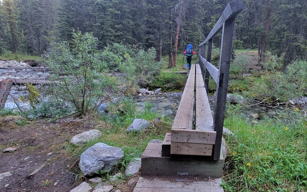

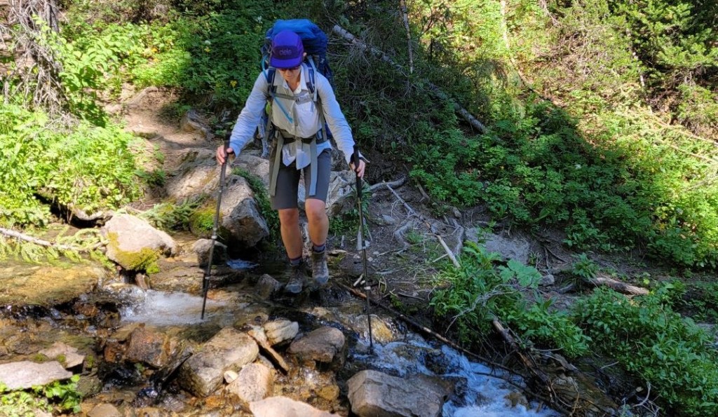
We followed a small creek, and then crossed over it about 1 km from the campsite.

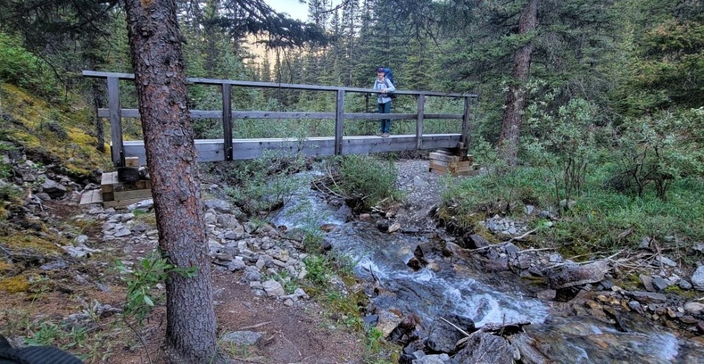

We kept gaining elevation all the way to the Pass, but the terrain was constantly changing so we were well entertained. We had several meadows, some thick trees, a boulder field, and then finally an open larch meadow as we neared the pass. The trail was sometimes faint in a few spots from braiding, water crossings, or rocks. We just hunted around a bit until we found the right path.


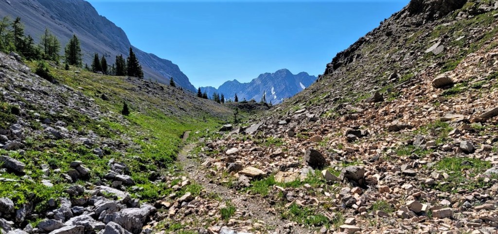
Lured by the promise of even more epic views, we dropped our heavy packs, and scrambled up the side of the ridge. There were several benches, and we just kept working our way across to the highest one. Worth it? Absolutely!


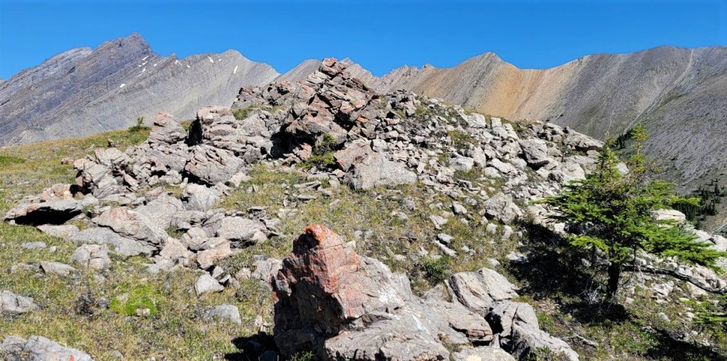

Distance to Mystic Pass was 6.5 km, with an elevation gain of 628 m. Time to pass (without side trip to ridge) was 2.5 hours.
Mystic Pass to Mystic Lake
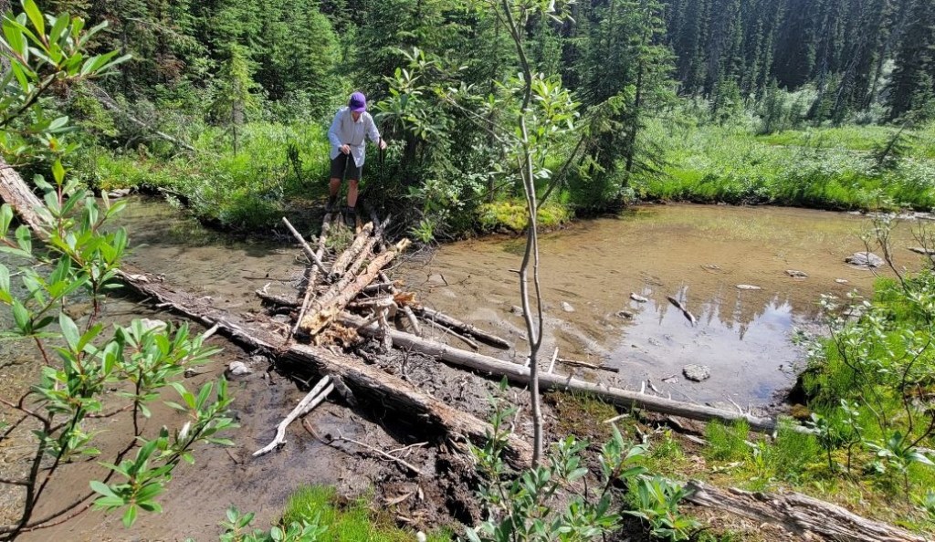
After summit lounging on the ridge, and eating a bit of lunch, it was time to descend off the pass and back into the trees. We still had amazing views for quite a while though, and took a short side cut to look down into a creek gorge. Trail finding was straight forward on this section – just head down.


The trail was straight-forward until we dipped back into the forest and got closer to Mystic Lake. The official trail on the map goes straight down, but the beaten-in path crosses the outflow of a small lake higher up to the west. Which is right? I can only assume that the trail got rerouted during the 2013 floods.

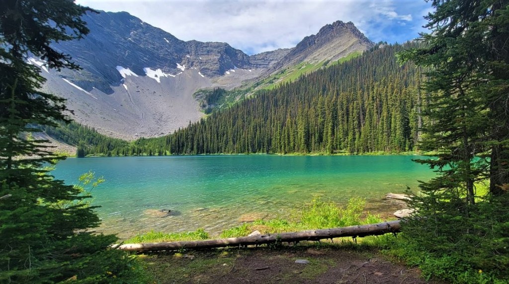
Shortly after the boardwalk, we came to the Mystic Lake junction. The campgrounds and junction are to the left, so if we wanted to visit Mystic Lake, we’d have to do it now. We stashed our packs out of sight and reach of the birds (yes I’ve had ravens and crows pull zippers and help themselves), refilled our water bottles from the nearby stream, and hiked up to the lake.

The trail to the lake is probably only 750 to 1,000 m from the junction, but it’s slow going as we neared the lake. Lingering snowmelt meant higher than normal water levels and mushy ground. The lake itself was beautiful, but off limits. There was some sort of water-based bacteria or disease, and Parks wanted everyone to stay out of the water.
Distance from Mystic Pass to Mystic Lake was about 5 km, with an approximate elevation loss of 266 m. Time from Pass to Lake was 1.5 hours.
Mystic Lake to Mystic Junction Campsite
After hiking back from Mystic Lake, we picked up our backpacks and continued on to our campsite. It was now early afternoon, and the sun was beating down. As we hiked on, we left the tight forest and were in open meadows. After a long cold winter, the heat was almost unbearable and a real energy sapper for every little uphill section.
We passed by Mystic Valley (Mi22) campground, which was located on a bench above the trail. The water source was the creek down below, accessed via the bridge. This campground seemed to be an open meadow, without tree coverage for the tent sites, but I also didn’t go hunt around looking for any either. This is a fairly popular campground, so I’m sure it is more than adequate.

After crossing the creek, we continued hiking to the Park Warden’s Mystic Lake Cabin. The Warden cabins were the first structures in the Parks, so they have the BEST spots by far. We poked around the grounds for a bit, admiring their close access to the creek for water, and the perfect amount of shade trees. I definitely missed my calling…

Just past the Warden’s cabin, we turned Left at the junction. There was a very short but seemingly ENDLESS hill to climb up from the creek and towards our campsite. I will admit to being tired at this point, and quite ready to take a load off my back. I may have whined (just a bit) going up this hill.

I was very happy to see our campsite, and to set up my Big Agnes Tigerwall tent once again.
Distance from Mystic Lake to Mystic Junction Campground was approximately 5 km, and took 1 hour and 45 minutes, including time at the lake and Warden’s cabin.
Fm19 Mystic Junction Campsite
Mystic Junction campground has five tent pads, one big picnic table, and a metal food storage box. There is also a fire ring surrounded by long benches. The water is also nearby and easily accessed.
As would be the trend on this trip, we saw only one other couple at this campsite. And wouldn’t you know it? It’s a VERY small world! I met the woman a few years prior on one of my very first Highwood Cycle Club rides. We chatted for a few hours, and shared some hot chocolate so she could lighten her load. They had booked this campsite only a few days earlier, as their plans had changed and they needed a quick getaway.

The whole Mystic Pass, Lake and Valley is an extremely beautiful part of Banff National Park. Take my advice, and slip in here and enjoy this pristine area before word gets out.
Click HERE for Day Three as we hike along the base of the Sawback range to Sawback Lake.
Thanks for reading! Please do me a huge favour and click the Star button to “Like” it. You can also follow my blog, join my FaceBook page Al’s Adventurers, or follow me on Instagram
Alisen
I love all things mountains! I live next door to the Canadian Rocky Mountains, however I travel the world to enjoy the many different mountain environments and cultures that I can. I hope you enjoy these trip reports, and that it inspires you to accomplish your own adventure goals.

We’ve thought about doing a similar route, since everything else is always booked up lately. Good to read your descriptions. That’s a great picture of Mystic Lake. Maggie
It was a great trip. I’ll have Badger Pass out in a day or two. That’s worthy as well.
Whoot! Day 2, done! 😀 … gotta love those pristine alpine lakes, and the blue skies. No colour we humans have invented even comes close. 🙂
I agree. It’s an almost impossible colour. Today was pretty long, but Day 5 was the hardest. Coming soon!
It sounds like you found the perfect match for a backcountry hiking partner in crime. Looks like you had fabulous weather and wonderful views. The colour of Mystic Lake is stunning. That’s too funny that you bumped into someone you’ve met before at the campsite. It is a small world indeed.
Yes, Erin and I are well matched. Not too many people will sign up for six days of this. We have a five day trip planned for the end of this August, but we just found out one of the key bridges is washed out. Hopefully either Parks will fix it (not likely) or the river will be low enough to cross. Fingers crossed!
That’s awesome that you’ll be doing more backcountry camping this summer. Hopefully the bridge will get fixed by then. I’m never a fan of river crossings without an actual bridge.