August 27, 2025
After only a one day break from doing the 82 km Brazeau Loop backpack, it was time to hit the mountains again 🙂 This was the only day that Mike and Dianna were both free, so I had to suck it up. Glad I did, as this was one of the most enjoyable scrambles I’ve done all year. A big thank you to Dianne for suggesting this route.
I hadn’t seen Dianne since the previous June when we completed the epic Kokanee-Kane-Woodbury glacier traverse, so we had a lot to chat about. So much chatting, that we both didn’t remember hiking the entire massive scree slope to the base of the false summit. Now that’s how you pass the time!
This is a Nugara Moderate scramble, and we found his route description very helpful. I really liked the scrambling – excellent rock, and we always found good hand and foot holds. The false summit was more intimidating on paper than in person. Once above that, the terrain changed often with lots of opportunities to make it as difficult as you want. The summit offered amazing views of Gibraltar, Mist, and Rae, among others.
The weather was stiflingly hot. About 30, with nary a breeze. I was definitely conserving my 1.5 litres of water, which is usually more than enough.

Gear
Hiking boots, scrambling helmet, poles, and regular day pack kit.
Overview
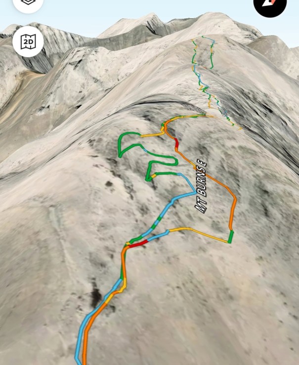
Drive to the end of Highway 546 (Sheep River Road) to the Junction Falls trail head. Park on the lower level. Walk to the upper level, past the gate, and up the old road. Take the first turn off, and follow a narrower track that switchbacks up. Make a hard left turn to follow the pretty good trail through the forest and up to the open ridge. Once on the scree slope, follow the ridge line to the base of the false summit. We skirted across the east face, finding a fairly good trail and the all important cairn. Once across, continue on the ridge, dodging and weaving the big blocks left or right as the terrain dictates. For the final push to the summit, Nugara suggests taking the scree to the right, but we missed that note. Instead, we scrambled up onto the ridge head on. At the summit, we saw the beaten in screen trail and took that down, saving time and avoiding down climbs. Otherwise, we retraced out steps back down.
Totals – Downloadable Tracks on Gaia, Displayed on Strava
Date: August 26, 2025
Group: Three (Alisen, Mike and Dianna)
Distance: 12.43 km
Elevation: 1,210 m
Time: 8 hours 20 minutes (includes lunch and breaks)


Parking and Trail Head
Drive the Sheep River Road (Highway 546) to the very end at Junction Falls. Avoid parking at the top of the loop, or you might be trapped by some very large equestrian trucks and trailers. Park down below, then walk back up to the gate. Almost immediately, we took the right hand fork and hiked a slightly narrower track. We stayed on the road until we hit the up track in the forest, slightly less than 1.5 km from the lower parking lot.

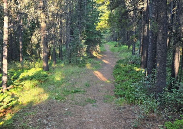
Main Trail
The forest trek had a pretty good trail, but there turned out to be several of them. There is flagging in the trees, but not always for the track I was on. Regardless, a very easy forest section.
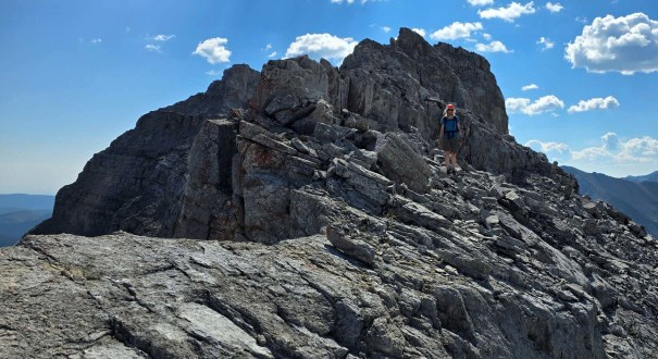
We popped out onto a very nice scree ridge. As mentioned in the intro, Dianna and I talked all the way up, and I really can’t say I minded this section. Once on the scree, we hit one scrambly section.


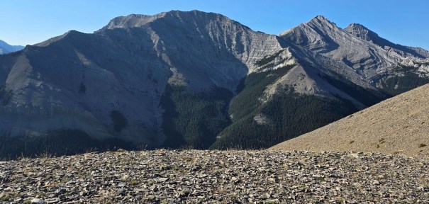
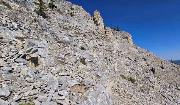
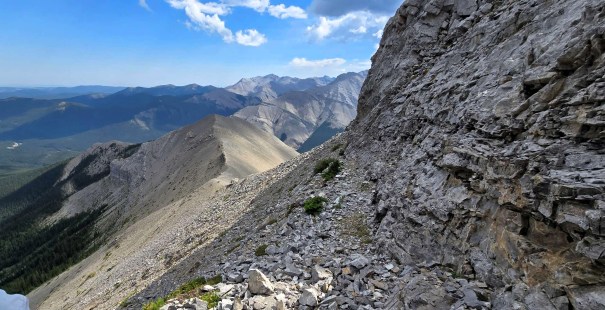
The scree ridge lasts for a long time. There are several sections that look tricky, but are by-passed on the right side.

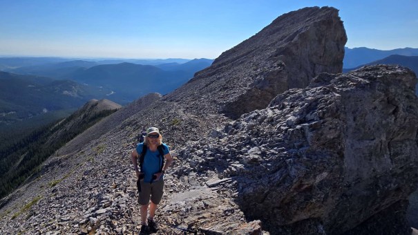
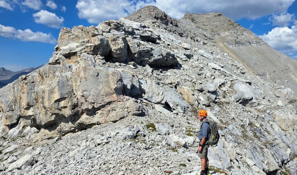
The false summit dominates the skyline, and I was positive this was our final destination. We could see the true summit poking out from behind, but it looked too far away. I guess I was more tired than I thought after the five day backpack.

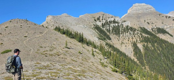
Once at the base of the false summit, we conferred with Nugara’s route options. We choose to go right and traverse the east face. We scrambled across to a small rib. From here, we could view the full basin and most of the route. We scrambled more or less straight up on grippy rock covered with loose rubble. We found some smaller cairns, and a pretty good trail through the rock bands.
We spied THE cairn, high on the right ridge. This lead to a path that took us off the east face and onto the connecting ridge.


Despite the 30 degree heat and zero breeze, this ridge was a lot of fun, but slow. Many options – up, left or right. Nugara suggests to go head on, or drop to the right when necessary. Every time we dropped down, we seemed to regret it and tried to get back up onto the ridge as soon as possible. I will fully admit that we dickered around here, discussing route options. This slowed us down, but it sure was fun.
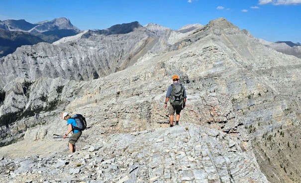


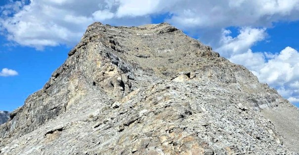
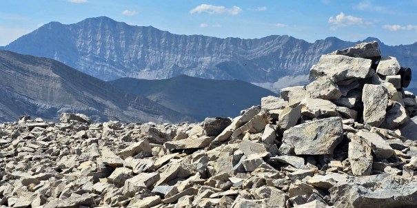
East Ridge of Mount Burns Summit
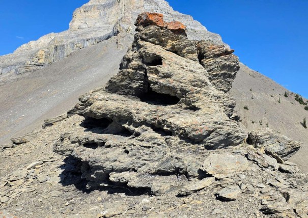
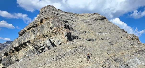
The final obstacle was the summit block, and it looked daunting. There were several rock bands to deal with. Mostly, we skirted to the right, and then found a weakness to get on top of the ridge. For the final rock band, we dickering around on the right side trying to find a way up. I finally discovered that head on worked. Some nice big steps up to the ridge top. Then it was a lovely hike to the summit on top of the ridge.


Time to summit was 4 hours, 30 minutes. Distance was 6.7 km and ~1,011 m elevation gain on Gaia. My Suunto watch was more generous at ~1,200 m.
Interestingly, the route on my map is called Mount Burns East, but the summit is labeled as Monty Burns Peak.


There are great views up here of mountains I’ve done from Highway 40, like Mist Mountain and Mount Rae. To the south is Tunnel O’ Fun, Shunga-la-she, and Gibraltar Mountain. To the east, Bluerock dominates, but Mount Ware and Volcano Ridge are right next door. Dot Mountain / Missing Link are further east.
Return Route
We had a leisurely 30 minutes on the summit, beating off the swarm of flying ants on the summit cairn. So gross. While we were eating, I noticed a beaten in trail in the scree, just below the ridge. We took this down, saving us a tonne of time and avoiding the down climbs on the final summit block.

We enjoyed the quick scree descent, and then weaved our way through the big blocks as we neared the false summit. A storm was brewing to the north east, and lighting was booming. The 30 degree heat and mugginess was oppressive, with only a slight breeze when we were on the east side. We definitely hustled down through the maze of blocks.
Once at the false summit, we descended to the big cairn. From there, we zig-zagged our way down. What was an obvious route on the way up, was not so much on the way down. We finally got onto a good line, and took it down to the scree below. By this time, the storm had petered out. We stayed dry and were not struck by lightening. Yeah!

As we hiked the long scree ridge, hitting high point after high point, Dianna and I both realized we really didn’t remember this at all. That’s the power of great conversation. Mike was laughing at this, as he did all the route finding up here, knowing we were otherwise engaged.
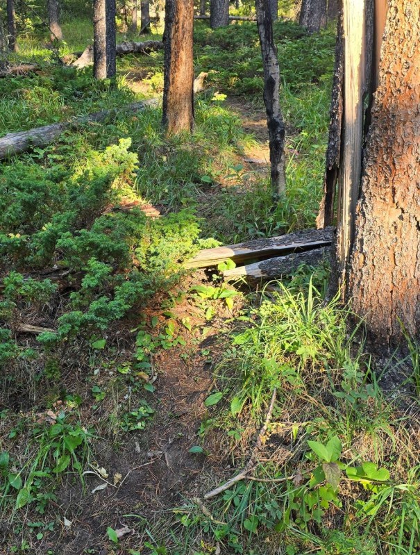
The trail through the forest was again obvious, it just wasn’t the trail we took up. No worries – the forest is nice and wide open, with very few downed trees.
Once we were off the forest ridge and onto the main trail, we took a short cut through the trees to cut off the switchback. This wasn’t too bad, except it’s a bit swampy and we made some mosquitoes very happy.
When we got back to the parking loop, the upper lot was full with massive trucks and even bigger horse trailers. Good thing we walked the extra distance.
Wrap Up
The East Peak of Mount Burns is a great summit. Unlike most of the scrambles in the area, this one has almost zero approach. What it lacks in approach though, it makes up for in a super long ridge to the summit. The false summit is a bit of a trial. The route after that is fun, with good route finding. The summit block is as hard as you want it to be, with a scree by-pass if desired.
A big thank you to Dianna for suggesting this route, and for waiting three months for me to get my act together before we went.
Thanks for reading! You can follow my blog, join my FaceBook page Al’s Adventurers, or follow me on Instagram
Alisen
I love all things mountains! I live next door to the Canadian Rocky Mountains, however I travel the world to enjoy the many different mountain environments and cultures that I can. I hope you enjoy these trip reports, and that it inspires you to accomplish your own adventure goals.

Great post as usual Alisen!
Your description of the false summit and shifting terrain is vivid and precise. I really like the photo of “Dianna scrambling up onto the top of the final rock band.”!
Well done Alisen. Thanks for dedicating the time to write and to share this post with us
Thank you for stopping by and reading it. This truly was one of my better scrambles this year. Truly enjoyed this peak.
‘…Alisen dangerously close to the summit… had a bit of a giggle at this when I saw who was credited with the photo … Dear Mike, EVERYTHING up there is dangerously close to the edge. 😀
😉 Out of everyone, I KNEW that YOU would pick up on that and get the joke. I often say that I am dangerously close to something – it can be as benign as being close to the crosswalk. It’s a fun thing to say.
As for Mike, he’s immune to heights. Me, not so much. I have to work SO HARD to not be scared to death. However, I get mine back by taking Mike into tunnels whenever I can. Mwa ha ha! 🙂
Ha, why am I not surprised to hear you went hiking a day after coming back from an 82km backpacking trip! Sounds like having good company can help with some of the gnarly scree sections. Love the rock formations along the way and views of the summit. The flying ants don’t sound fun though! Glad to hear you weren’t impacted by the storm.
Thanks Linda – it’s rare that I am in good enough shape to do that. The stars aligned 🙂