February 2, 2021
I have been saving Mount McNab for the winter doldrums – not enough snow to ski, yet cold enough for the Sheep River to freeze over. I got my chance in early February. It hadn’t snowed since late December, and with never-ending chinooks, the snow pack was all but gone. The only skiing was over two hours away in Peter Lougheed or near Lake Louise. Not wanting another big drive, today was ideal for Mount McNabb
Mount McNab is located near the (surprise! surprise!) Sandy McNabb campground in the Sheep River Provincial Park in southern Kananaskis Country. We used to come here a lot when our kids were little, but have recently returned to start exploring the area anew. Other fun hikes in the Sheep River park are Mt. Hoffman, Little Ware, and Missing Link.
For some reason, Mount McNab is spelled with only one ‘b’ while the Sandy McNabb campground has two. I have tried to get some information on Sandy McNabb, but all I can find is a Scottish footballer. If you know the history of Mr. McNabb, please leave a comment below.
Gear
While there wasn’t much snow, I still wore gators and micro spikes, in addition to my poles and regular day pack kit.
If you hike Mount McNab in the summer, consider bringing river crossing shoes and some sturdy poles.
Overview
From the lowest day use area at the Sandy McNabb campground, walk towards the Sheep River. Cross the river and start ascending the lower slopes. There are three small hills, the third being the summit. At the top of each hill, turn right to keep going towards the final Mount McNab summit. Return the way you came.
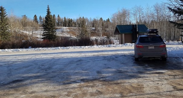
Parking and Trail Head
From Highway 546, drive to the winter gates and turn left into the Sandy McNabb campground. Follow the road to the bottom of the hill, and park in the lowest Day Use Area parking lot.
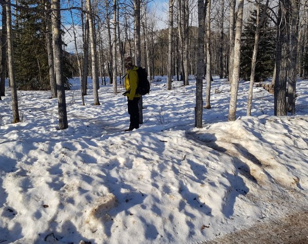
From the parking lot, head south west towards the Sheep River. Descend the embankment to the lower road, which is now closed since the 2013 flood washed it away. From the lower road, keep going down to the Sheep River and find a good crossing point. We waited until February to ensure the ice would be frozen, but we still found an open patch. On our return, the ice was visibly melting.

When crossing in the summer, avoid the spring / early summer run off. High water can be found all through June as the snow from the upper mountains starts melting. Crossing in late August, September and October should see the lowest water levels UNLESS it’s been raining heavily. Remember that the water is lowest in the morning, and rises throughout the day.

Main Trail
Once we crossed the Sheep River, we hiked up the embankment to a flat open area. We turned left, while the Sheep River trail went straight, paralleling the river.

At the top of a knoll we found a wooden cross poking out of the snow. Does anyone have any history on this cross? If so, please leave a comment below.

Back down the other side of the knoll, there is a short stroll through a meadow, to the base of Mount McNab. From here, we began hiking up.


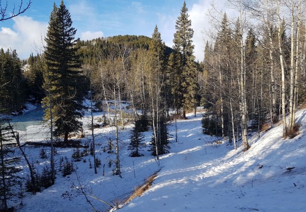
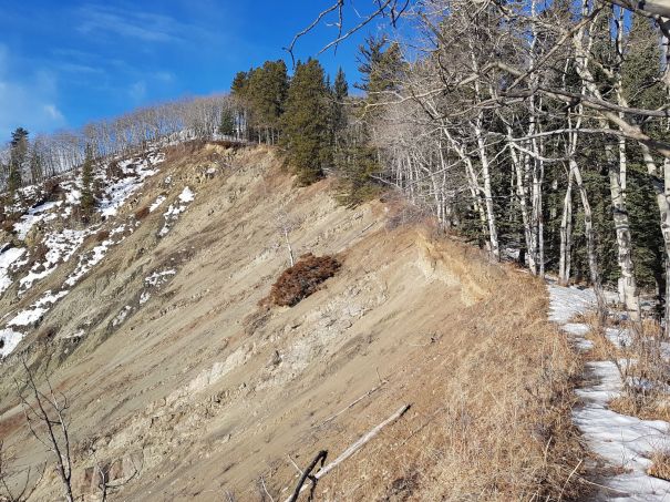
We stayed on the ridge above Fox Creek. The first slope has significant erosion, probably helped by the 2013 flood. This is about 1 km from the trail head.

At the barbed wire fence. we elected to leave the ridgeline, and follow the fence. On the way back, we ended up following the ridge. Both ways are good.

The summit of Mount McNab is basically the third of three hills once you leave the Fox Creek ridgeline. I’m sure there is a good summer trail, but as I look back at my photos, it’s just one big forest walk. We relied on situational awareness and dead reckoning to keep going in the right direction.
At the top of the first hill, we turned right to follow the land contours to the dip between the first and second hills.

The ascent to the second hill saw the most elevation gain. At the top of this feature (about 2.4 km from the trail head), there was a ridgeline that we followed to the right.


Again, we dipped down to the low point, before the final up hill to the true summit of Mount McNab.


Apparently, you do not hike Mount McNab for its amazing views. We were surrounded by trees on all sides. If we had continued in the same direction, there is another West Peak. I later heard that the views were better from there. Oh well.
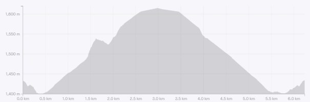
Distance to the summit of Mount McNab is 3 km. Elevation gain is 214 m (706′) from the Sheep River.


Mount McNab Return
We returned the way we came.
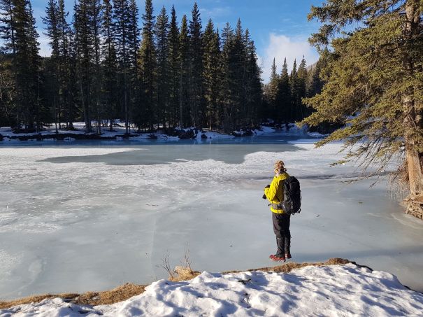
We did take one small detour that did not pan out. We thought we could avoid the final knoll (with the cross on top) just before the Sheep River. We walked over to Fox Creek, which had stunningly beautiful blue ice. We wanted to walk down Fox Creek to the Sheep River, but the ice was way too soft and wet. Oh well. We trudged back the way we came, and went up and over the little knoll.

When crossing the Sheep River on the return trip, we had to re-assess the ice. It had warmed up considerably since we started, and the ice was showing signs of melting, especially near the shore. Despite a thin layer of water on top, the ice held.
If you found this post useful, please do me a huge favour and click the Star button to “Like” it. You can also follow my blog, follow me on Instagram, or join my FaceBook page Al’s Adventurers.
Alisen
Totals – Tracked on Strava
Date: February 2, 2021
Group: Two (Alisen and Mike)
Distance: 6.24 km
Elevation: 266 m (878′)
Time: 3 hours (includes lunch & breaks)

I love all things mountains! I live next door to the Canadian Rocky Mountains, however I travel the world to enjoy the many different mountain environments and cultures that I can. I hope you enjoy these trip reports, and that it inspires you to accomplish your own adventure goals.

Great post Alisen!
the photo (last one) by the Fox Creek, looks stunning!
Thanks! I agree – not much
Whoops! Not much to look at on this trip 🤣
Thank you for sharing your adventures! The photos are very beautiful. I agree that the frozen Fox Creek photo is my favorite.
Thank you so much. My aim is to inspire others to go on their own adventures – whatever those might be.
That’s great! I don’t ski but I love walking the trails. In my younger days I went rafting. That was a wild ride! Peace.
👍
Xoxoxo
Love to return to Alberta..such a great mountain area to hike.
Yes, I agree, it is a great place to hike, mainly because it’s so accessible. You can drive to most trail heads, and there is usually an outhouse near by too.
When we return to see our son we will head there.
I love reading your descriptions, I feel like I was coming along and the photos are just so amazing… So beautiful, thank you.
Wow – thank you. That is so kind of you to say. I am glad you felt like you were there. I hope to inspire people to do their own adventures, whatever that might be.
This looks like a lovely area to go for a hike in the winter. I have no idea how you managed to navigate that trail though. I have such a terrible sense of direction and rely heavily on trail markers or blazes.
Oh, I hear ya. I do a lot of backcountry skiing, where there is zero trail, so you just get good at situational awareness and general reckoning. I bet with all your hiking that you are actually better than you think – it’s amazing how much you pick up.
An absolutely stunning location and a fabulous read. Thankyou. Xx
Thank you for the kind comments!!!
Thanks for your like of my post, “Road To Tribulation 9” I appreciate your kindness.
Woww thank you for sharing this
This too beautiful…the images looks dope
Thank you very much, but the scenery does the hard work. I just point and click 🙂
It took some digging to find this, at highcountrynews.ca
Alexander “Sandy” McNabb was a noted horse trainer when he arrived in Turner Valley during the 1913-15 oil boom and began working for the Royalite Oil Company. This native of Scotland also loved fishing and spent many of his days off riding the rutted road west from Turner Valley to his favourite fishing hole on the Sheep River near here. Oldtimers still recall his tireless efforts to distribute food to Royalite’s unemployed during the hungry 30s. In recognition of his work as a founding member of the Turner Valley Fish and Game Club, the Association designated Sandy’s old fishing spot as “Sandy McNabb’s Camp”. The recreation tradition continues today at the campgrounds and on the trails of Sandy McNabb Recreation Area.
Hello John,
Well done!!! Thank you so very much for finding this information. This is so very much appreciated – you have made my week!!!
I will update the post and include you as the man who tracked down the elusive Sandy McNabb.
My friend Susan Raby-Dune, who is a historian living in Longview, was also trying to find information on Sandy. I will share it with her as well.
I think the other person who might like to know more about Sandy McNabb is fellow Scot Gillean Daffern herself. I think she would like to hear from you personally though. I have a contact page for her if you like?
I’m sorry for the late reply. I was in the Tonquin Valley and Nordegg for 8 days, and am just now getting back to work.
We have another mystery going with the Shunga-la-she name. I’ve contacted Gillean to try and find out more, as all other searches have come up blank.
Thanks again John!
Alisen
You are very welcome Alisen, I didn’t do much other than dig through webpages, out of idle curiosity. I’m not sure if I could offer anything more to Gillean other than what I posted. I think some of the confusion comes from the variation in spelling of the surname McNab/McNabb. You would think that Parks would have a brief history of whom the area is named for, but NO. Maybe the good folks at highcountrynews would have more information.
Happy trails! I live in Mexico now and sorely miss the Alberta foothills and mountains.
Hi John,
I passed along your information to Gillean Daffern. I was asking her about the naming of Shunga-la-she, and thought she’d appreciate hearing about Sandy McNabb.
Funnily enough – she had the exact same reaction as you. If Parks was going through the effort of naming a mountain after a person, they could at least spell it correctly!
Enjoy Mexico, which I know you will once the snow starts flying up here.
We are having a lovely fall so far, although I did find more snow than I would have liked last week in Tonquin Valley near Jasper.
Take care, and thanks again for your web sleuthing.
Alisen