March 24, 2021
Coyote Hills was originally on my radar as a way to avoid the intense, blasting west winds during the shoulder seasons in the spring and fall. My original objective was Junction Hill, but since I had been blown off it several times, I thought I should try something more protected. Luckily, Coyote Hills was just across the street, and its east facing slopes were exactly what I was looking for. Now that I’ve hiked Coyote Hills, this ranks as one of the nicer hikes in the south Highwood area. The views of the massive mountains further west are stunning, and the final summit ridge makes the trudge through the lower forest well worth it.
We decided to do the loop traverse, which I would not recommend unless all the snow has melted. Read on to find out why. Also, this is not a good winter hike objective. The slopes are steep, and the final slope to the summit is an unsupported avalanche slide path. While we found just the final lingering winter snow, we went out of our way to avoid even that bit of snow.
This trip report is for the West Coyote Hills. The East Coyote Hills are visible from the winter gates on Highway 40.
Gear
Hiking boots, poles and your regular day pack kit.
Overview
From Highway 940 (south of Highwood House), park at the trail head. There is a bit of a pull out, but no parking lot or facilities. Hike down the old blocked off road, until it’s time to head up and gain elevation. There are two small hills, before a dip in elevation marks the final hill to gain the ridge. To reach the summit, head north west and follow the ridge to the end.
Return the way you came, or follow the steep ridge down to Baril Creek. Cross the creek, and return along the south side of the creek until the highway. Hike back north a short distance to the start.
Parking and Trail Head
From the south gates on Highway 40, we turned south onto Highway 940. After about 2.8 km, we found the vague location of the trailhead on the west side of the road, right before the Baril Creek ‘bridge’. This is an active logging road, so we were sure to pull way over to the side.

Once we walked up the small embankment, the trail itself was easily found on the flats above. We continued across the short meadow, and past a small berm that now blocks access to the old road from motorized vehicles.

Main Trail
Once on the old road, it was easy to follow, even in the snow with no tracks.
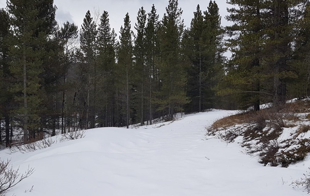
After about 800 m from the trail head, we came to a Y junction. This is an opportunity to cross Baril Creek on the loop route.

After the Y, the trail started to gain elevation as it followed the ridgeline above the creek.
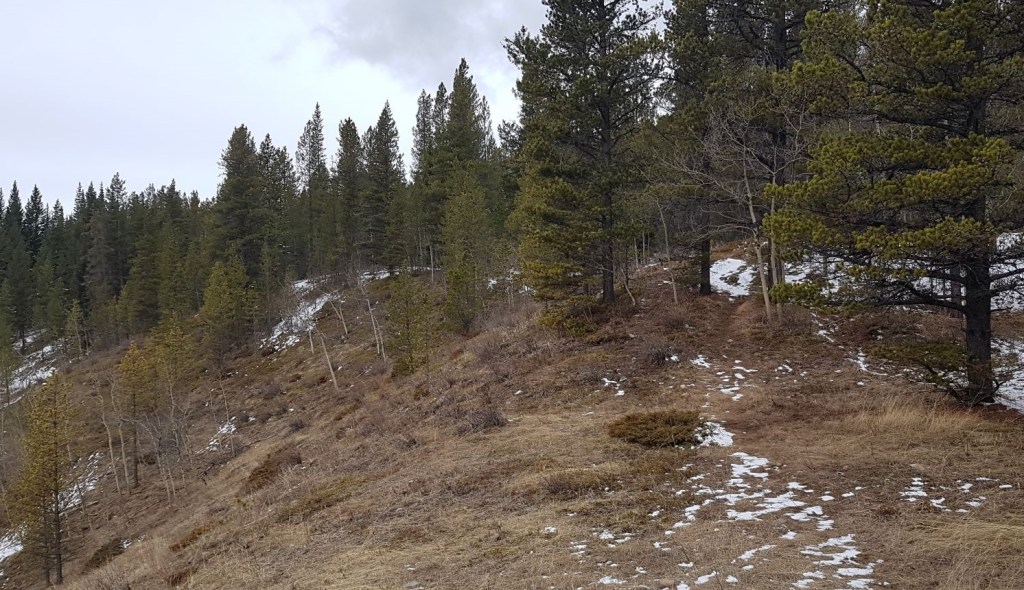
At around the 1 km mark, we found a blaze on a tree. This turned out to be the major clue that we should start heading uphill to gain the first of the three Coyote Hills. We kept going past this point a ways, and then had to wind our way up the slope. Fortunately (or confusingly), there are about 1 million animal trails up here, so we did a combination of following faint trails, and striking off uphill.


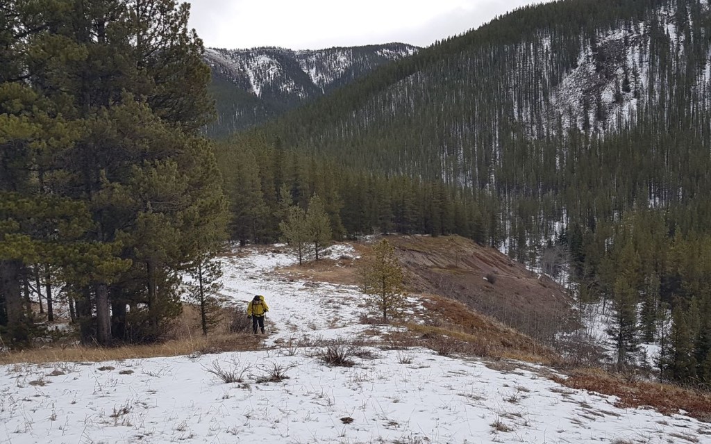
Once at the top of the first hill, we could look across at the second hill, and the final summit ridge on the far right.
The trip from the top of the first hill to the top of the second hill is an uninspired tramp through the forest with nary a view to entertain.

The view from the top of the second Coyote Hill is pretty sweet, and one could make an argument to stop here.

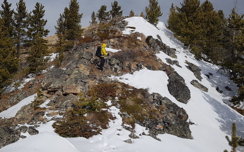
Once on top of the second hill, we could eye up the route to the final hill. The open slope directly across is the route up. The trail snakes up this hill, which is an unsupported slope that looks like it slides often. Even though there is a pretty good trail heading up, we chose to go off trail to avoid the lingering winter snow on the left side.

This is a good opportunity to assess the optional loop. The descent is down the rather steep ridge of the final Coyote Hill to Baril Creek below. Once across the creek, it’s a flat walk back to the road.

After losing some elevation, we started up the final slope to gain the ridge of the third and final Coyote Hill.


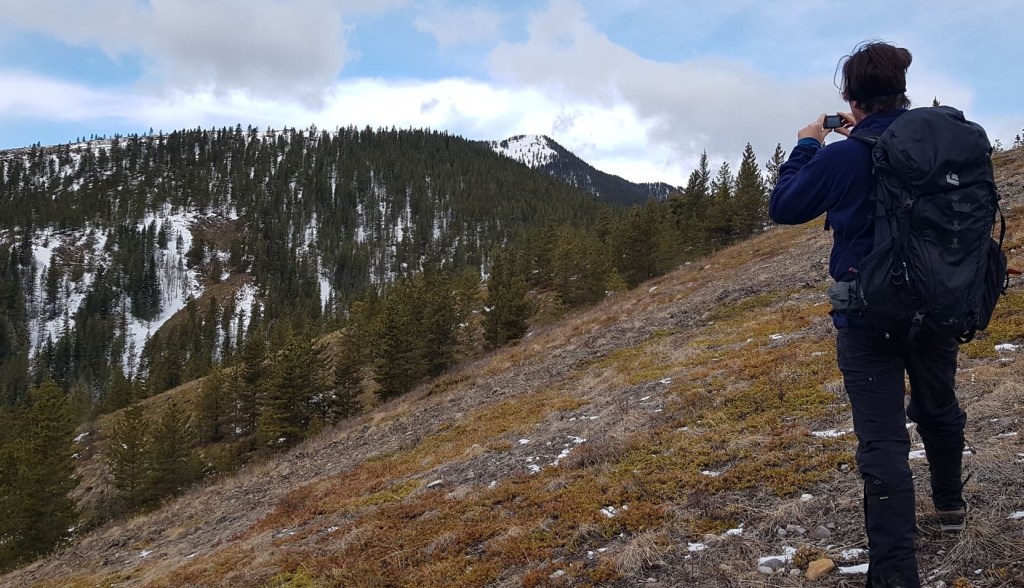
Once on the ridge, things finally started to get interesting. First off, the views were absolutely stunning! Being able to see Mount Armstrong up close was spectacular. Then, the ridge itself was delightful. Rocky outcrops made the final push to the summit a delight.
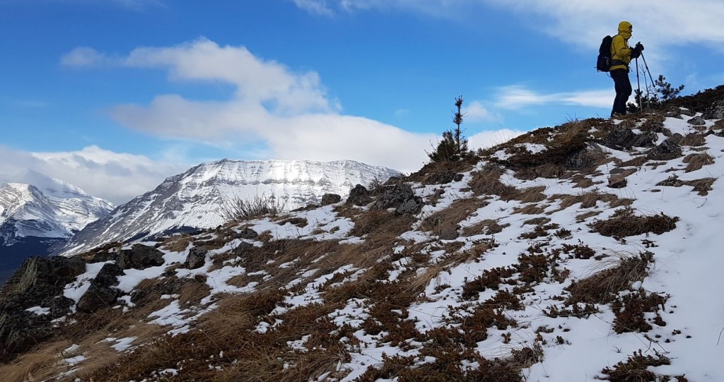

The summit of Coyote Hills gives an impressive 360 degree view of pristine mountains.
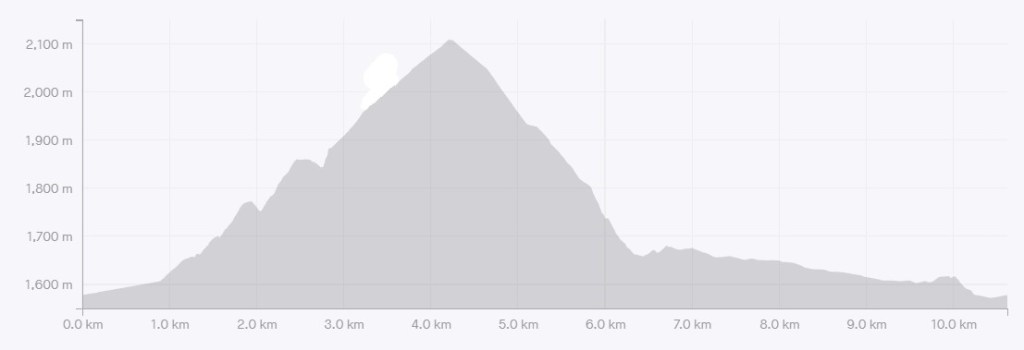
Distance to the summit of Coyote Hills was 4.2 km. Elevation gain was 567 m. Time to summit was 2 hours, 30 minutes.


Coyote Hills Return
One way is to retrace our steps and return the way we came.
However, I thought it’d be fun to do the loop. We hiked back down the ridge to the saddle, and then kept going. It was a lovely walk at first, but then it got pretty steep.


Once at the bottom, we had a short bushwhack to Baril Creek. Mike found the ideal crossing point.
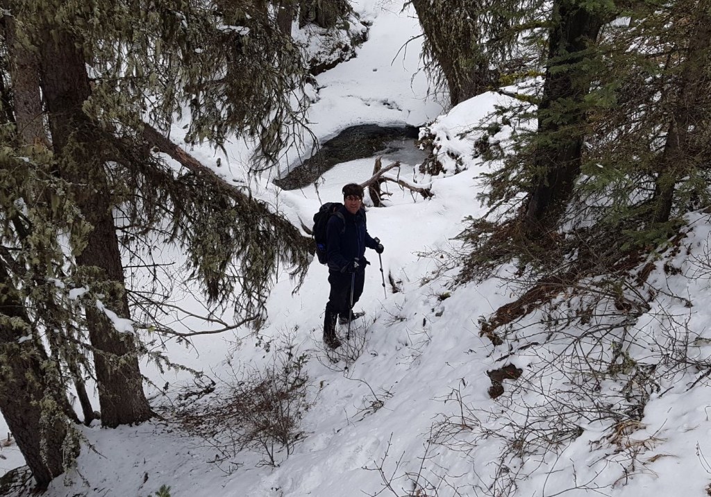
It was a rather thick bushwhack up the other side of the creek, trying to find the trail that we knew was there.
We found a side spur, which we thought was the main trail. No one had been down here, and we were post-holing up to our knees in spots. Uh oh. This was going to take forever to get home. Luckily, the spur joined with the main trail, and it was easy walking back to the road.
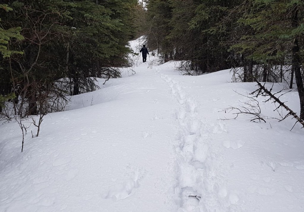

There is a bit of flagging that marks the spot where it’s possible to re-cross Baril Creek (the Y junction on the way in). We elected to keep going straight, which put us on the highway maybe a 200 m away from our van.

While I initially chose Coyote Hills to avoid the worst of the west winds, I truly enjoyed this hike. The views at the top were unexpectedly good, and it was nice to explore this area.
If you found this post useful, please do me a huge favour and click the Star button to “Like” it. You can also follow my blog, follow me on Instagram, or join my FaceBook page Al’s Adventurers.
Alisen
Totals – Tracked on Strava
Date: March 24, 2021
Group: Two (Alisen and Mike)
Distance: 10.62 km
Elevation: 695 m (2,294′)
Time: 5 hours (includes lunch & breaks)

I love all things mountains! I live next door to the Canadian Rocky Mountains, however I travel the world to enjoy the many different mountain environments and cultures that I can. I hope you enjoy these trip reports, and that it inspires you to accomplish your own adventure goals.

What an amazing hike that must have been. The photos alone are incredible!
Thank you so much Rebecca! It was an unexpectedly delightful hike. I’m glad we did the loop, if only to warn others LOL!
Looks like a very doable hike. What do you think … Maybe completely snow free by mid June?
Oh, absolutely. I’d almost wait until July though, to ensure the water levels in Baril Creek are low enough. Either that, or bring water shoes for the crossing. I really could not judge how deep the creek is. It might be a trickle all year long, in which case even May would work.
Thanks 😊
I wonder what that structure was. My first thought is an old hunter’s cabin. Also, it looks like maybe spring is coming your way. There’s not quite the amount of snow, is there?
Yes, I originally thought a hunter cabin, but the crossbar in the middle makes it way too small. It’s hard to see in the photo, but each room would be wide enough for just a single cot. The wood was notched out like they were building a cabin, and the wood is old enough to be from way back when. Those old timers didn’t have the time or energy to just fool around, so who knows what happened.
Yes, spring is trying to spring. We are now in Second Winter (what you don’t see, is a major snowstorm blew in that night, and it wasn’t possible to get past the second Coyote Hill the very next day).
Soon, we will begin the season of Hope. Hope lasts a depressingly long time. We normally don’t officially say we are in Spring until the May Long weekend (which is the weekend before your May long weekend).
I’m so glad to hear you say “second winter!” Not because I like the idea of it, but because I’ve talked about “second summer” for years, so it seems clear that if parts of the world closer to the equator can have a second summer, points farther north and south would have second winters. I send you and your husband as much sympathy as a second summer sufferer can give to people in their second winter. 🙂
Second summer… if only! 😂
This looks beautiful! Gotta love those loop trails in the spring where you accidentally end up postholing back to the car. I almost did one of those last week!
Yikes! Glad you avoided a heinous post-holer. They really are soul-sucking experiences.
It’s been a while since I almost got myself into trouble, so it was a good wake-up call.
A beautiful hike with amazing views!
You are a strong hiker..me..a bit weak..but looks like a great site to see
Ha ha. I’m sure you get along just fine. But yes, this was a very pretty hike.
I’m always amazed as to how you’re able to find the trailhead and then navigate some of these trails. Us hikers in Ontario are so pampered as most of our trails are marked. The views of the surrounding mountains look incredible. I can see why you wouldn’t want to hike this trail when there’s lots of snow, it looks challenging enough as is without it!
Well, you hit the nail on the head! Finding the trail head is the absolute CRUX of any hike. Last year, my daughter lead a trip up Mist Mountain. She started out on the wrong trailhead, hiked up 2,000′ of Storm Mountain, finally got above tree line to see where she was, then had to hike back down. They backtracked until they found the correct trail head, and then climbed Mist Mountain. All in, she probably did close to 7,000′ of elevation gain that day. However, this is nothing compared to BC. Alberta has a paved or gravel road to the hikes. In BC, you’re on a narrow, active logging road with ruts, holes, etc and always the possibility of getting high-centered, stuck, or break something. Very stressful driving if you don’t have a big 4×4 truck!
Kind of funny how it’s an adventure in and of itself to get to the trailhead. I can see why you provide such detailed advice on what to expect on the trails in Alberta and perhaps more importantly, where to find them!
Yes – you know it! 🙂
Hey! I nominated you for my interview with an adventurer. Don’t feel obligated to participate, but if you do I would love to read your responses as I always enjoy reading your posts. Have a super day!
Hi Tia – wow!!! Thank you so much for thinking of me. Yes, I would love to participate with your interview. I enjoy your posts as well. I’m hiking tomorrow (of course!), but will get on it as soon as I can. Again – thank you!
Alisen
So glad to hear! Have a fabulous day hiking!
Adorable
Coyote Hills Visitor Center contains educational displays and exhibits as well as the Possum’s Pocket Nature Store. The exhibits portray the Ohlone way of life and include a tule reed boat constructed by park staff and volunteers using Native American methods. Other exhibits cover the park’s natural history and wildlife.