July 9, 2021
I wanted to climb Eiffel Peak ever since I summited Mount Temple. Why? There is a spectacular view of the Mount Temple route that you can only see from Eiffel. Good reason, eh? Another reason is the absolutely gorgeous quartzite rock that is only found in the Moraine Lake / Lake Louise area. After slogging up limestone scree all year, I do look forward to at least one good ‘solid’ rock summit a year.
This trip was extra special for me because I was leading it. It’s a scramble, with some route finding. Plus, I was leading four friends, all of which had only ever hiked with me.

Gear
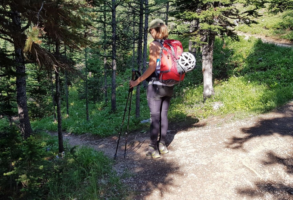
A helmet is highly recommended for all scrambles. While we had the mountain to ourselves, the risk of rock fall is always high on any route. Also have excellent hiking boots with good tread and ankle support. Your regular day pack kit and hiking poles is also advisable.
There are black and grizzly bears in this area. Please check with Parks Canada for any closures, or restrictions on the number of people travelling together. Bring bear spray, and having some bear training is advisable.
Overview
From the Moraine Lake Parking lot, take the lakeshore trail on the right, and turn right towards Sentinel Pass. Go past the Eiffel Lake junction, but then take your next left at an unmarked trail that leads to the creek crossing. After the creek, head up the ridge to the saddle. There you will see the route up Eiffel. Return the way you came.
Parking, Shuttle and Trail Head
This year, Parks Canada has created a special Park and Ride Shuttle from the Lake Louise overflow parking lot. I would HIGHLY recommend this. We pre-booked our time slot, which meant we could have a lovely drive up, and not worry about getting a parking spot, or having to arrive at 4:00 am. You can pre-book way in advance, but Parks also holds back 50% of the seats to be booked within 48 hours for last minute bookings. If you are a tourist, leave the car behind in Banff or Canmore. Click here to book.

We parked at the Lake Louise overflow, hopped on the shuttle, and arrived at Moraine Lake by 8:00 am.

From the parking lot, when looking towards Moraine Lake, we headed right on the lakeshore trail. Shortly after, we turned right to take the trail heading up to Sentinel Pass.
Main Trail
At the top of the switchbacks, approximately 2.5 km from the trail head, is the first intersection. Stay RIGHT and continue towards Sentinel Pass. Do NOT be tempted by the Eiffel Lake fork on the left. I knew we needed to go left, and thought this might be the way. We only got about 100 m when I noticed the trail losing elevation, so we turned back.
On our descent (almost back at the saddle) we met a group of guys who did NOT turn back. They spent five (5!!!) hours dicking around trying to find a way up Eiffel from the lake. It didn’t work and had to hike back to here.

About 1 km from the last fork, look for an unmarked but fairly obvious trail going down to the left. This takes you to the creek crossing.
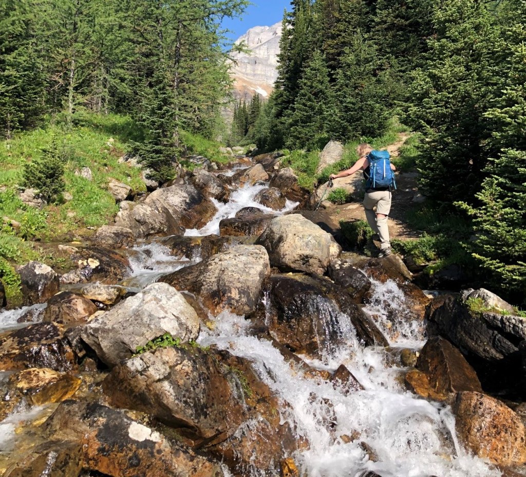
Once on the other side of the creek, it’s a straight shot up through the trees to the saddle below Eiffel Peak.

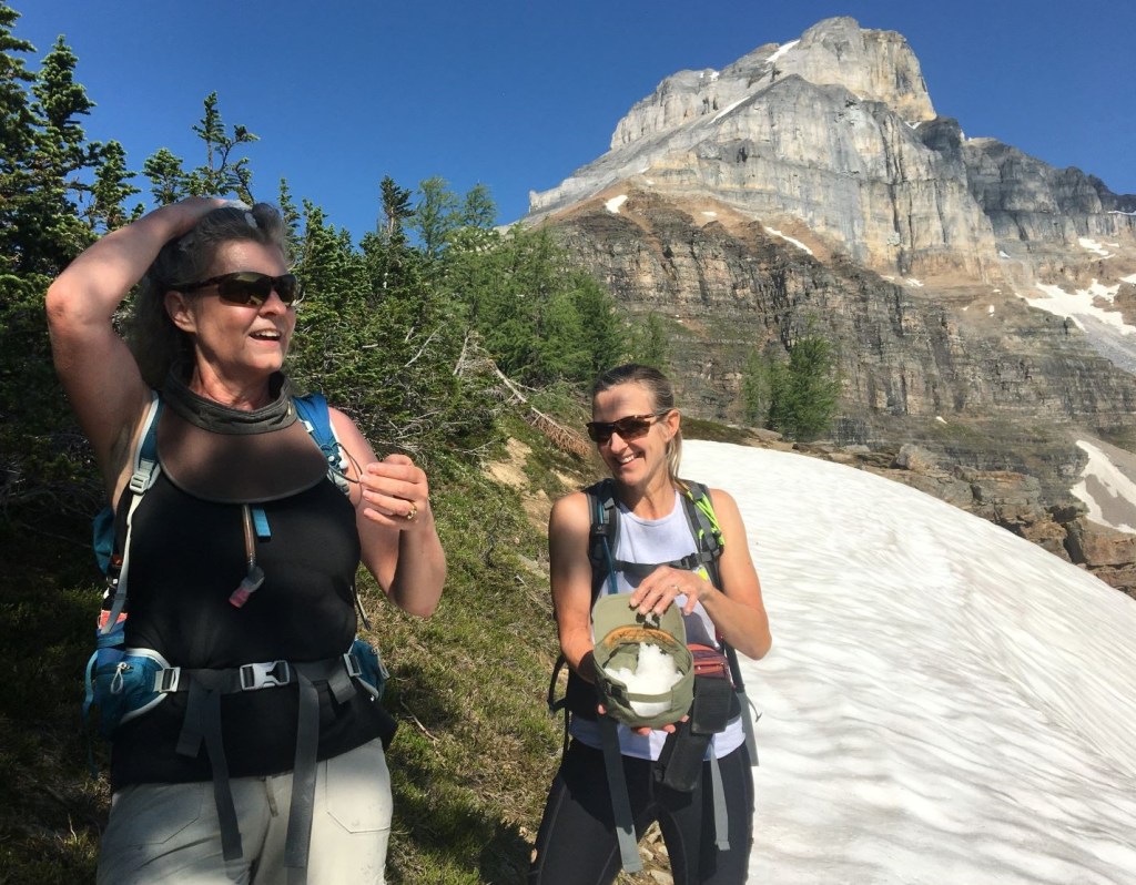
It was another smoking hot day in July, so I decided to share my Alisen Dopf Patented “How To Stay Cool While Climbing” method with the group. I found a small patch of snow, and we all filled our hats. Ahhhh…. so much cooler!
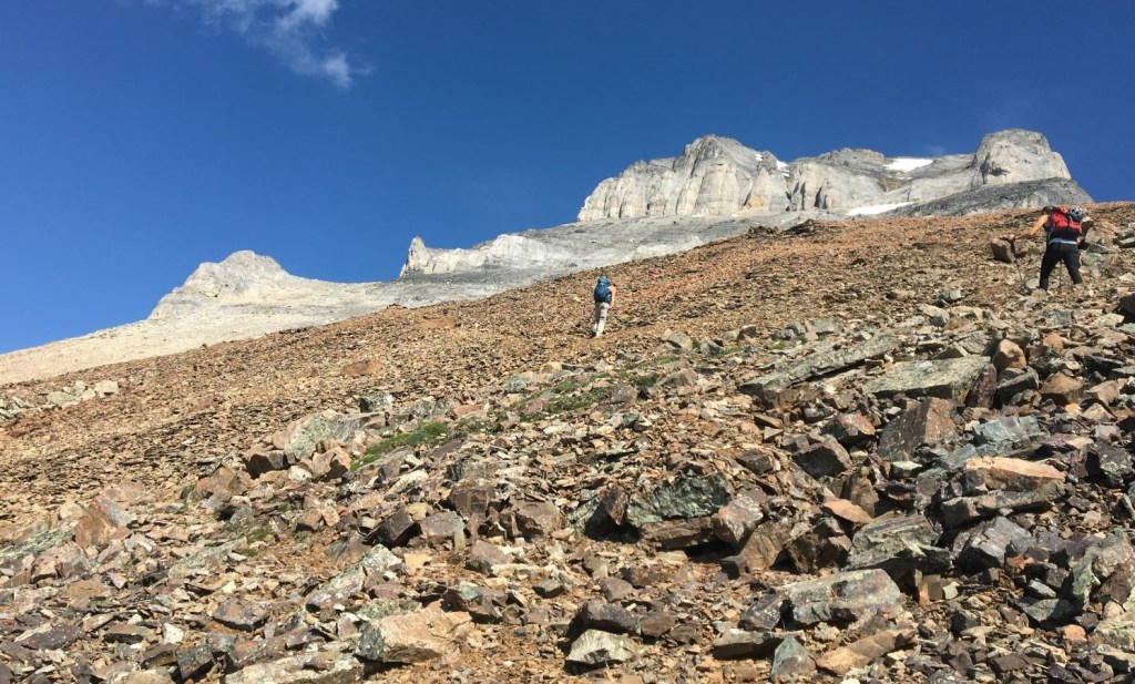
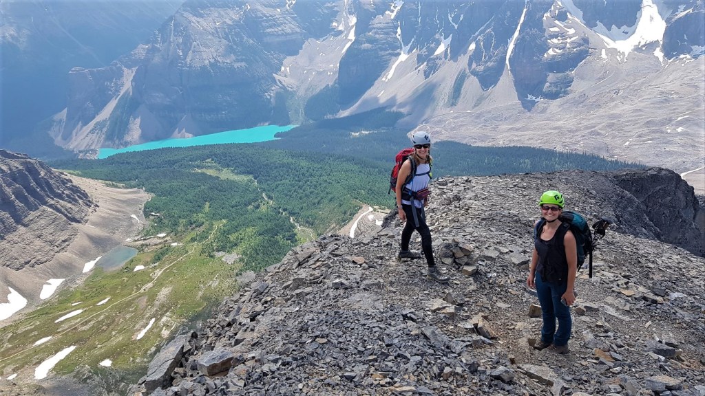
As we left the trees and got onto the saddle, we could see the route up Eiffel Peak. Of note are the two towers near the summit – light grey and dark grey. We were headed for both, and would skirt around to the left.

As we made our way up from the saddle, the trail was in great shape through the loose, red coloured rock.

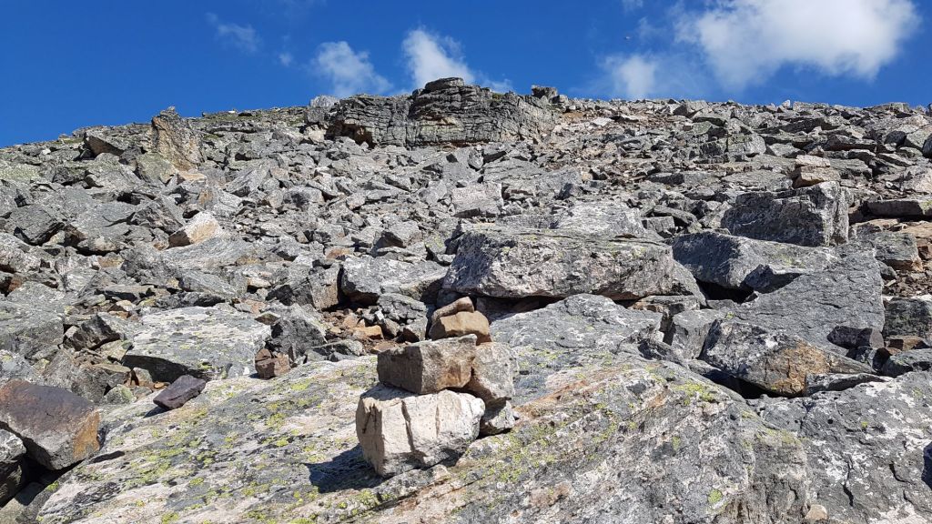
We crossed one section of large boulders, but it was easy to find our way with a series of small cairns, and looking for the worn away lichen.
Things didn’t get fun until we hit the white band. Here we had a bit of route finding as I picked our way through the rocks. We had a bit of hands on rock as we went up some short steps.


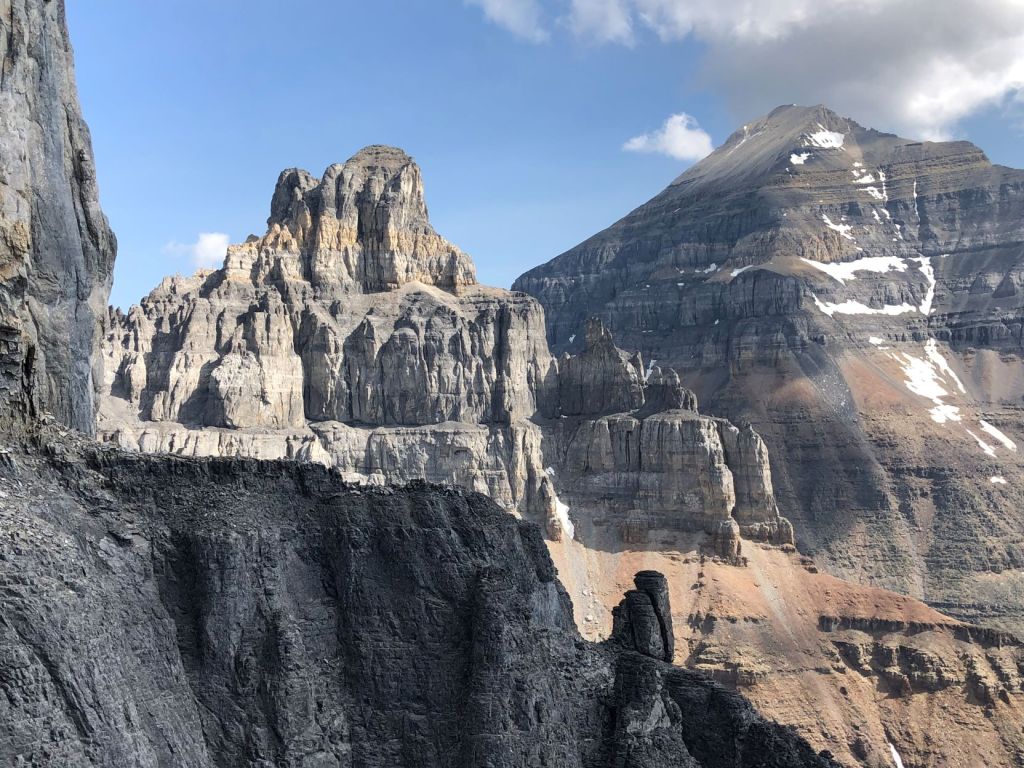
We are heading for the towers on the back right, on the horizon. The first is a light grey tower, that we skirt around on the left, followed by the dark grey tower, which we again skirt around on the left.

As we hit the outcrop, we were now at some amazing photo op locations. I really had to grit my teeth and avoid the temptation to keep the pace moving. I had to remember that no one (other than me) had ever been to this spectacularly beautiful location before, and that quite likely, some of them might not ever be up here again. Patience, it turns out, goes a long way to preserving friendships.

Once past this point, we had a lot more hands on rocks.
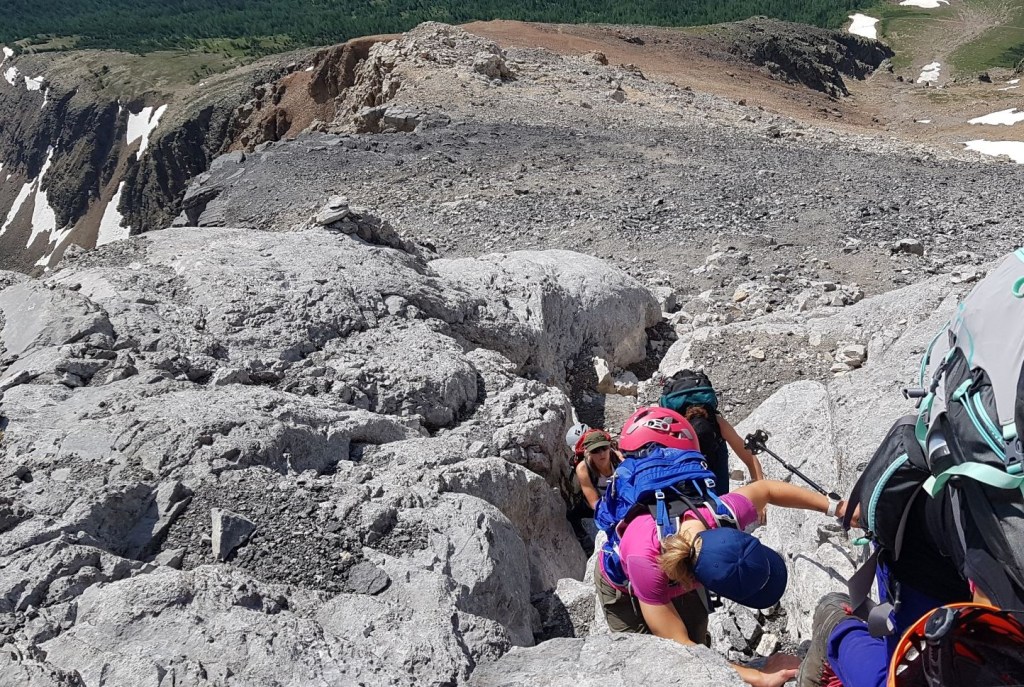
We got to the base of the first light grey tower and went around to the left.
To get from the first tower to the second dark grey one, we headed up a steep gully.

We came to a gap in the rock, that gave us a great view of Pinnacle.

This is looking back down to the gully we came up, and the gap in the rock with the view to Pinnacle.

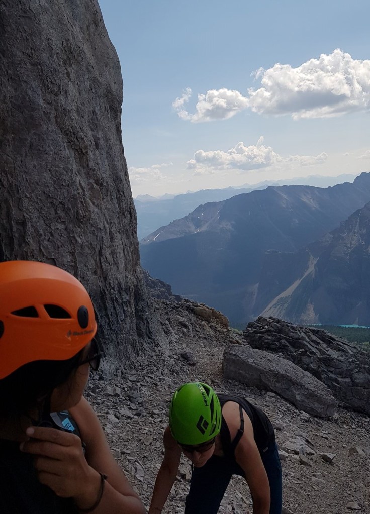
When we got to the base of the second dark grey tower, we took stock. It was here that I stashed two of our group. Rosalie and Aura were not feeling it, and the views from the top were not worth the trauma. I had to give them full marks for doing as well as they did. They were full on troopers! I could tell that Aura was having enough though, when she stopped calling me by my pet name of Alicia, and starting using my full name. Uh oh…
This was a great place to leave them, because they were completely protected from any rock fall from above, and they could move around on the flat area without any danger of kicking rocks down on any parties below us. We had the mountain to ourselves, but could not be positive of that at the time.
This next photo is terrible, but it shows the base of the dark grey tower, and the final route to the top. It looks benign, but it’s actually quite steep, with loose churning rock. I poked around a bit trying to find the best route. That turned out to be straight up a loose gully.

Once we got out of the crumbly gully, there was a delightful path on the right side that lead to the solid ridge. The cairn marks the spot where we need to descend to again pick up this nice trail.
Now it is a lovely walk to the summit of Eiffel Peak.

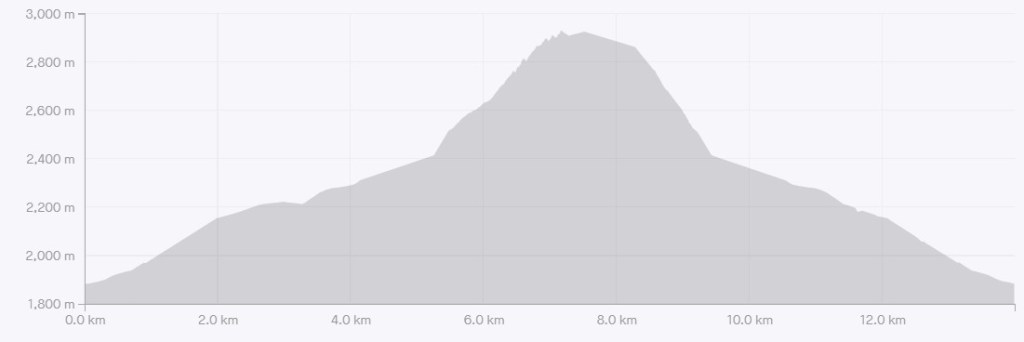
The distance to summit of Eiffel Peak was about 6.6 km. Elevation gain was 1,210 m. Time to summit was 4 hours and 15 minutes. This includes snack breaks, and endless photo stops 🙂
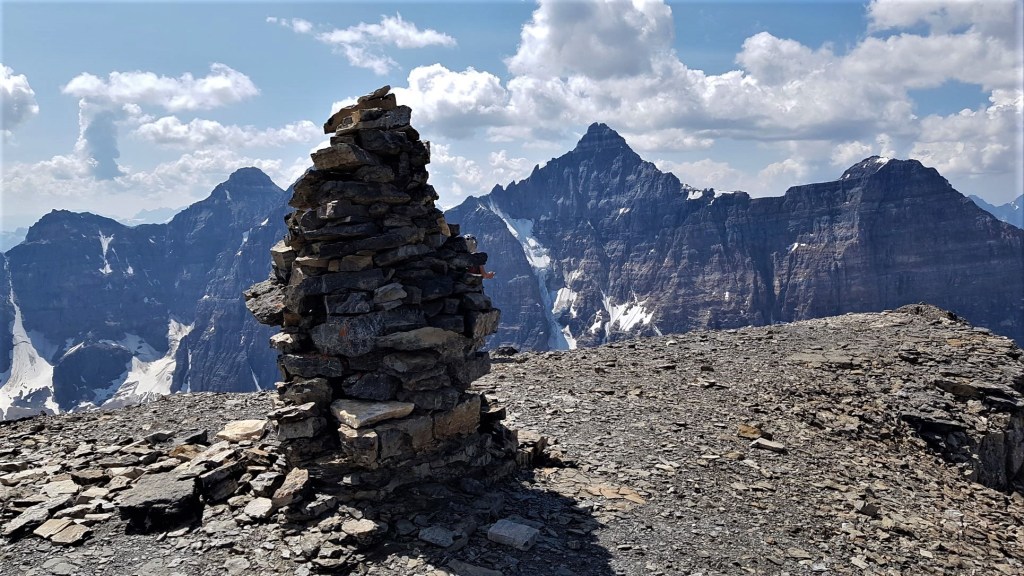

Looking down onto Horseshoe Lake Trail in Paradise Valley. Behind the lakes is Mount Lefroy. To the right is Mount Aberdeen.

Eiffel Peak Return
After lots more photos, Sonya, Erin and I descended back down to our stashed friends Aura and Rosalie at the base of the dark grey tower.

Picking our way down through the white rock.

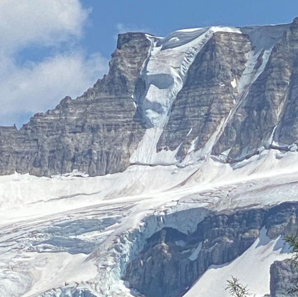
The moment you see it….
After staring at the Fay Glacier all day, the sun moved into just the perfect position to show us The Ice Man! By this time, we were back onto the Sentinel Pass trail, and I happened to look up. I screamed when I saw him, making several other groups dive for cover because they thought I saw a bear.
Once back at Moraine Lake, Sonya, Rosalie and Aura who had never even seen Moraine Lake before, all headed up to the Rockpile trail to catch the old $20.00 bill view. Erin and I stayed on the rocks, soaking our feet and watching the canoes launch. When everyone was back, we dove into the cold Moraine Lake waters to properly cool off. Aaaahhhh…. pure bliss on such a hot day.

This has been an amazing summer of summits, most of which I have lead myself. It’s a challenge to plan and execute, while also balancing personalities and the needs of each person. I really want to thank my buddies for saying YES to whatever adventure I place before them.
If you found this post useful, please do me a huge favour and click the Star button to “Like” it. You can also follow my blog, follow me on Instagram, or join my FaceBook page Al’s Adventurers.
Alisen
Totals – Tracked on Gaia, displayed on Strava
Date: July 9, 2021
Group: Five (Alisen, Sonya, Erin, Rosalie and Aura)
Distance: 12.4 km
Elevation: 1,210 m (3,993′)
Time: 8 hours (includes lunch & breaks)

I love all things mountains! I live next door to the Canadian Rocky Mountains, however I travel the world to enjoy the many different mountain environments and cultures that I can. I hope you enjoy these trip reports, and that it inspires you to accomplish your own adventure goals.

Wow! What an accomplishment … And absolutely stunning photos!
Thank you Ann – so very kind. It was a pretty special day, more so because I had to do it all myself. I lead hikes and easier scrambles all the time, but this one seemed bigger and badder. It sure helps with a supportive crew along, great weather, and fantastic attitudes.
What an absolutely beautiful place! Another great hike! I love the snow in the hat idea. I think it’s really “cool”. And the Ice Man is amazing!
I have a few more tricks to keep cool. I run hot and wilt in the heat. Built for the cold 😂
I understand completely! Right now Maine is my favorite place in the US even though I don’t live there. Peace. 🙂
Me too. Give me snow any day. 😀
I get ya. With over 6 months of snow here, I do try and enjoy summer as much as possible. Hiking and scrambling without a massive pack, ice axe, crampons, etc. is SO much lighter and nicer.
6 months!!! Where is this fabled shangri-la you speak of?
Canada. Siberia would also be a good guess 🙂
That stream you were sussing! 🙌
Oh my gosh, incredible views and an incredible accomplishment! Every time I see photos like this I just want to quit my job and spend the rest of my life exploring the Canadian Rockies. Beautiful photos!
Yes! It’s a rare and intensely beautiful part of Canada. I am so thankful it was preserved as a national park all those years ago. I agree about the quitting the job thing – I am as close to that as I can possibly be and yet still be employed 🙂
Thank you for taking me/us on this spectacular journey. 😀
Wow, Wow, Wow Alisen!
How lovely and what amazing views you had! I got a bit jealous (in a good way) by looking to all these lovely peaks!
That is HIGH praise coming from you!!! Thank you, my friend. SO glad I could get you going. I’ve been drooling over your peaks and waterfalls for some time, that I’m happy to return the favour. Of course, this is a very small area. I wish all the Rockies were like this, but then if that were true, it probably wouldn’t be this special.
I am in awe, I love the views, you are an inspiration! Well done for your hard work! 💕🙋♀️
Thank you – you are always such a sweetie. I appreciate you.
👍🙋♀️🤗
wow spectacular adventure and great photos!!! 👏👏👏👏
Thanks Cindy! It was fun, and I was indeed thankful for the excellent photos my friends took.
you’re so very welcome. It looked like a ball!💖 You’re friends are talented❣️
Another stunning hike although you always freak me out a bit when you start talking about bear spray etc!
LOL! You are not the only one 🙂 Truth is, bears are everywhere. Just a few days ago, I went for a road bike ride with my girlfriends. About 10 minutes after we rode a stretch of road, I packed up my bike and drove home along that same stretch of highway, only to have to slow down to let a big old black bear cross the highway. So, they are everywhere, but some places are more *likely* to see on than others.
That’s amazing. I can’t picture them as being so ‘ordinary’ and wandering through the countryside, but then I guess other people would be equally surprised at all the kangaroos at my back gate!
Yes! Or a koala bear up your tree! To be fair, seeing a bear anytime IS a really big deal as they are apex predators. My point is they are everywhere, even if you can’t see them. Creepy, I know 🙂 Even creepier? The cougars! You will ONLY see one of those if it decides to eat you.
Hmmm, you are not doing a great job of marketing this walk! 🙂
I hiked to Eiffel Lake a number of years ago and didn’t even realize you could summit Eiffel Peak. The path looks a bit sketchy, especially with that river crossing, but the views are incredible! Not only did you successfully guide your group of friends, but you also provided some great advice! I laughed at your “How to Stay Cool While Climbing” method!!
Parks Canada does not put any scrambles on the map. We have a hard enough time keeping random tourists on the main trails 🙂 NOT that we don’t want people finding the trails, but we want people to be prepared. We have a bit of trouble these days with people just showing up and following random trails just ‘to see where they go’. Search and Rescue is having to do a record amount of retrievals and rescues. It’s getting a bit ridiculous. And these are LOCALS and not international tourists!
When I was mountaineering last week, it was SO hot that my helmet was always filled with snow. No one else did it, and I marveled at their ability to stay cool without a bit of snow air conditioning.
That would explain why I didn’t see this one listed on the Parks Canada website as a hike in Banff! It’s surprising to hear that people will go off trail in the mountains. So much could go wrong and clearly does given the record amount of retrievals and rescues. This is something I would never do without a guide. It’s been hot and humid here the past few weeks and I could go use some of that snow air conditioning!
I’ve heard about the heat and humidity. I feel for you! Is it okay at your cottage though? Looks like a lovely spot in the heat of summer.
I can take you up Eiffel if you ever want to do it 🙂
This gives me a great excuse to return to Banff 🙂
We actually haven’t had too much time to visit the cabin this summer. We’ve been on a few camping trips and are haven’t completely unpacked yet. The list of things to do is never-ending. We’re hoping to visit this fall when the leaves are changing colour.
Wow!What a beautiful place! How beautiful photos are !🤗👍🌺
Wow!!! what a view 😄
Thanks! It’s a beautiful part of Canada.
Wow what a hike. Ice Man is so awesome
Yes! Isn’t he amazing!! If you look closely, you’ll see a second face in the rock to his immediate left. AND… if you look back through the photos of that same glacier, below the Ice Man is a monkey or baboon face lower down in the ice.
LOL!!! You are too funny, my friend 🤣 Nope, I guess I’m not.
Whenever I feel like traveling or hiking I come to your blog. Not sure you write so beautifully because you travel or you travel places so you write so detailed and interesting. Keep traveling and will travel with your blog.
Oh my goodness. Thank you so much for your kind words. I have spent the last two days struggling through a long trip report, and your words have renewed my resolve to get it done. A sincere and heartfelt thank you, my friend.
I am glad you’re able to join me on these virtual hikes. I wish you adventure in your own life, in whatever manner that strikes you.
Alisen
Molto molto bello ma molto molto faticoso😁
Complimenti per le fotografie!!!
Ciao da Rome Italy
Thank you very much! Thank you for visiting this beautiful part of Alberta. Hugs from Canada!
😁
[…] på flera spännande upplevelser. Svårklättrade Pinnacle Mountain (2937 m) och det något enklare Eiffel Peak (3081 m) ligger alldeles ”runt hörnet”, precis som Mount Temple vilket med sina 3545 […]