June 1 – 15th
I have ridden the Highwood Pass from the south side for several years. It’s a great early season ride with a lot of elevation. It is my litmus test for how I’m doing – do I need to cycle more? Or am I right where I need to be?
I am a member of the Highwood Cycle Club in Okotoks. They take their name from – where else? The Highwood Pass. Every year the club organizes several group rides to tackle this road.
When to Ride
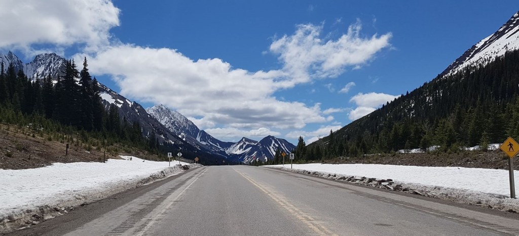
The road re-opens to car traffic on June 15th. However, in order to make it all the way to the Pass, you need to wait until the road is plowed. This generally happens in early June, but it’s dependent on when the road crews have time. Sometimes the road is not plowed until a few days before the road opens, especially if there has been a lot of late spring snow.
If you call Alberta Parks and ask about road conditions, you will get a stern “the road is closed!” A good friend of mine found this out the hard way. Also because the road is closed, there will be snowplows and possibly street sweepers on the highway. They will not be looking out for you, you have to look out for them.
Gear
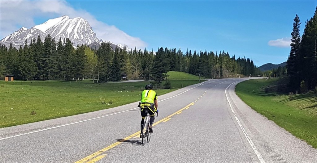
Any bike will do, and I’ve seen them all on this road. I use a road bike because it is light and fast. Mountain bikes and hybrids also work.
Be prepared for all weather, and for extreme weather fluctuations between the start and the pass. Bring a small backpack or panier for food, extra water, and extra warm clothing. While you might work up a sweat cycling up, it is a long, fast and cold ride coming back down. I’ve had frozen fingers from the ride down. Not ideal when you have to brake and change gears.
Bears & Other Animals
Bear Spray is highly recommended. You are all alone on this road, and the bears are down low eating dandelions in the ditch. Leave the bears alone. Do not approach. Do not even stop! When every cyclist stops and looks at a bear, eventually the bear will get mad and take a swipe at you. This bear will be hunted down and killed. Do not be a bear killer.


Bike Etiquette
When I first started biking the Highwood Pass, the road was empty. I could ride all the way there and back and count the number of people I saw. Now it is super popular. While it is tempting to take up the entire road, please be mindful of everyone else cycling.
If you need to stop, move over to the far right. You might be alone this second, but a group could be coming up or down at any minute. This is especially important for large groups. Last year, a cycle club (wearing identical bright yellow jackets – you know who you are 🙂 ) took up the entire lane because one member had a flat tire. They were stopped on a corner. As I came blasting down the hill, I had to weave through other cyclists in my lane who were trying to pass the stopped group.
When passing, please announce yourself. Saying “on your left” is good enough to alert the cyclists ahead, or ring your bell if you have one.
The same goes for the e-bike crowd. You STILL have to announce that you are passing another bike! We cannot hear you coming. I had an e-bike zip past me and my partner on the Moraine Lake Road yesterday with no warning, and we just about crashed.
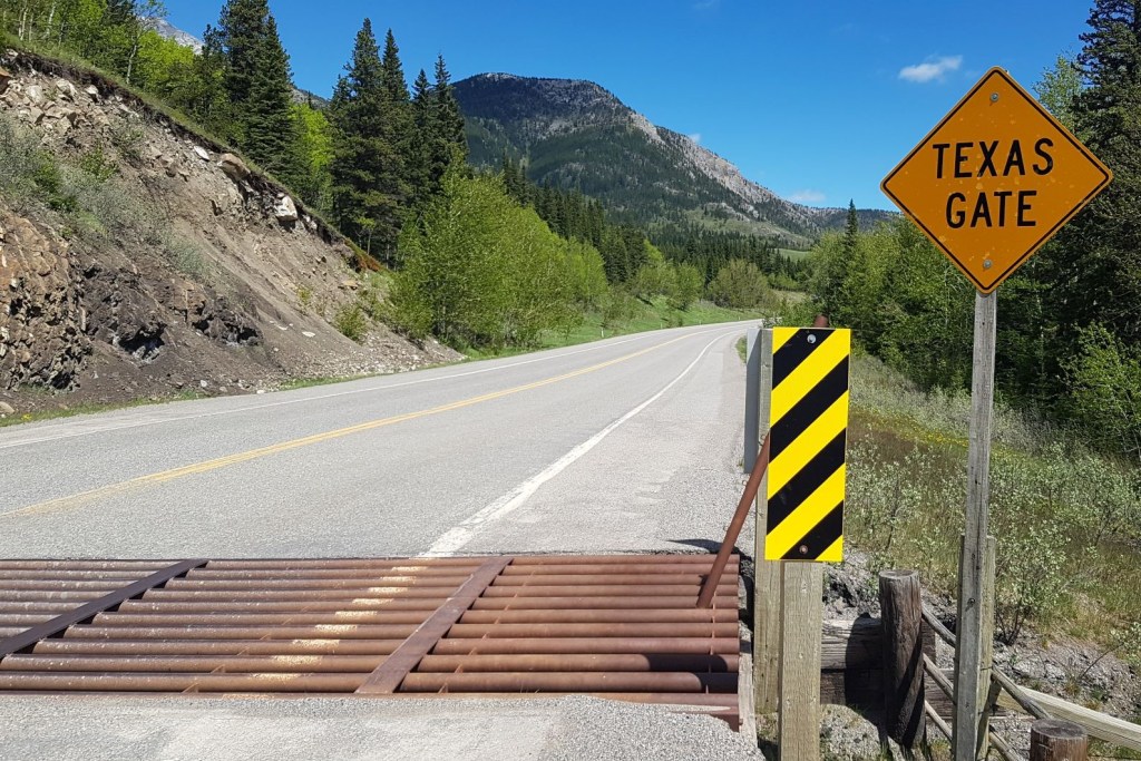
Texas Gates
This is cattle grazing country, and the main way to keep the cows from walking away is the use of cattle guards, known as Texas Gates here in Alberta (but oddly, not in Texas). These are a series of round metal bars inset in the road that prevent cattle from continuing down the road. They have thin strips of metal to cycle over.
To safely cycle over these, line up your front tire with the thin strip of metal. As soon as you hit the Texas Gate, stop looking down and focus on something straight ahead. Your bike will automatically stay straight, and you won’t fall off the thin strip.
You can also choose to simply bike over the rumble bars. It’s not pleasant, but if you keep up your speed, it’s over quickly.
Overview
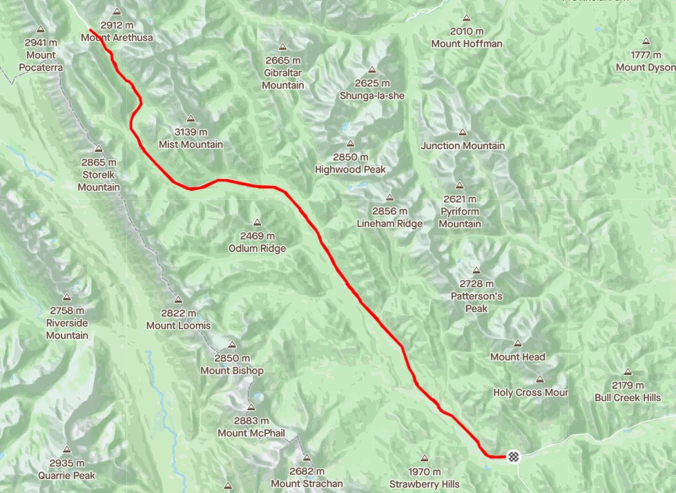
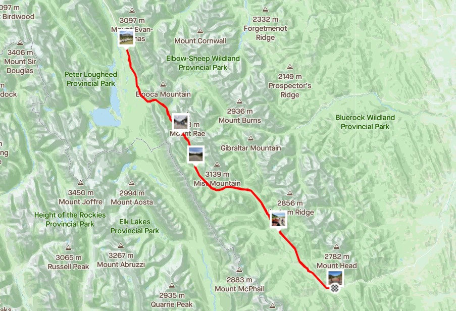
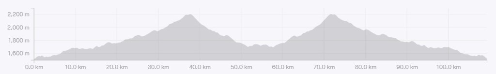
From the south winter gates, start cycling. Stop when you have had enough, or when you reach the Highwood Pass. The super fit cyclists will continue down the other side for 110 km and 1,609 m elevation for the full Gate (south) to Gate (north) to Gate (south) experience, known as G2G2G.
This video is a highlight reel of the Highwood Pass cycle.
Parking and Trail Head
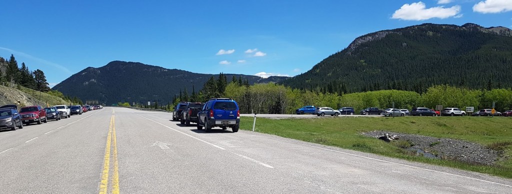
Park at the winter gates on Highway 541 / 40 south. Please park with consideration to the hundreds that will come after you.
Please do not be tempted to park along both sides of Highway 940. This is an active logging road. Logging trucks always win. There is a pull out a few hundred meters down the 940 on the west side.
Wheel your bike around or through the winter gates, hop on, and away you go!
There are NO washrooms or outhouses at the gates. The only facilities are at Sentinel Day Use area, which is just past the Kananaskis park gates on the south side of the highway. The next outhouse is at the Fitzsimmons Creek Day Use area, which is just shy of 3 km from the winter gates. I would recommend bringing your own supply of toilet paper. I don’t know how well these technically closed washrooms are stocked in the off season.
Please do not pee and poop all over the winter gate area. Do not leave any toilet paper either. Pack it in / pack it out EVEN on the road side.

Main Trail
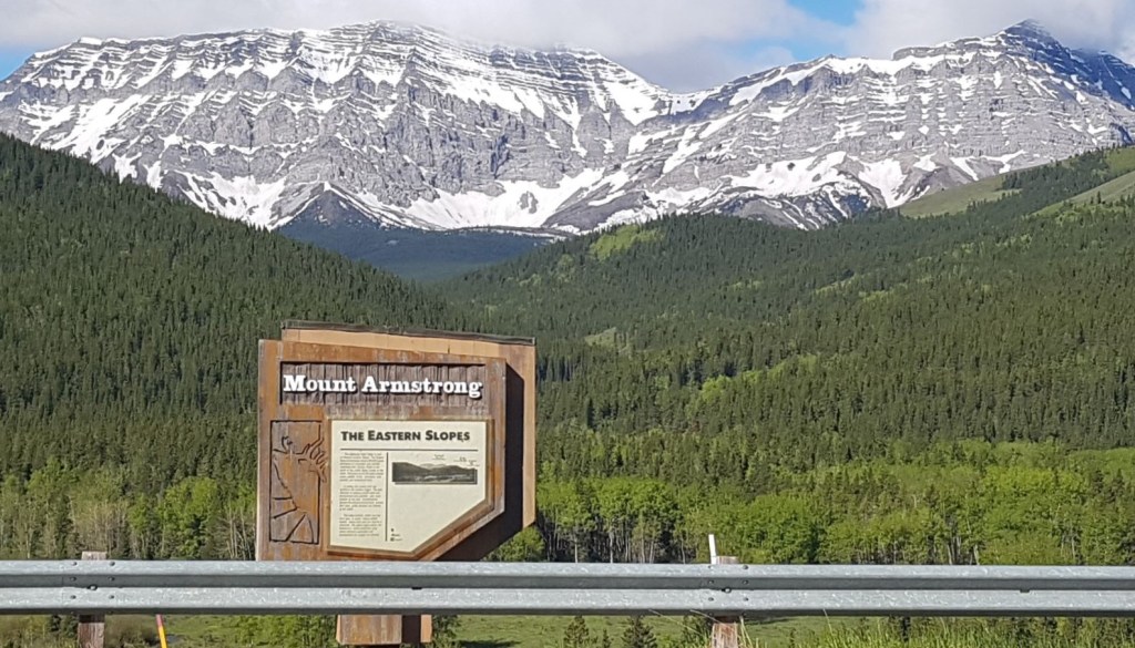
The cycle starts out with a long and steep uphill. No warm up. Go slow, get your legs and lungs working. At the top, you are rewarded with stunning views of Armstrong.
I love this cycle, because I have hiked from just about every single parking lot on the south Highwood. I always gauge my cycling progress based on the trail heads along the way.
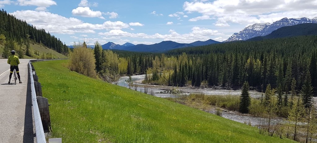
The first Day Use area is Fitzsimmons at about 2.8 km, and the Cat Creek Day Use area follows shortly after at 6 km. If you are cycling with young kids, or don’t want a massive day, then Cat Creek is a great spot to stop. You can explore the Highwood River, or cross the highway and hike the short Cat Creek Interpretive trail.
At 11.5 km is the newly (since the 2013 flood) reconstructed Lineham Provincial Recreation Area. Just down the road at 17.1 km is the Lantern Creek Provincial Recreation Area. This is the trail head for Picklejar Lakes across the highway.
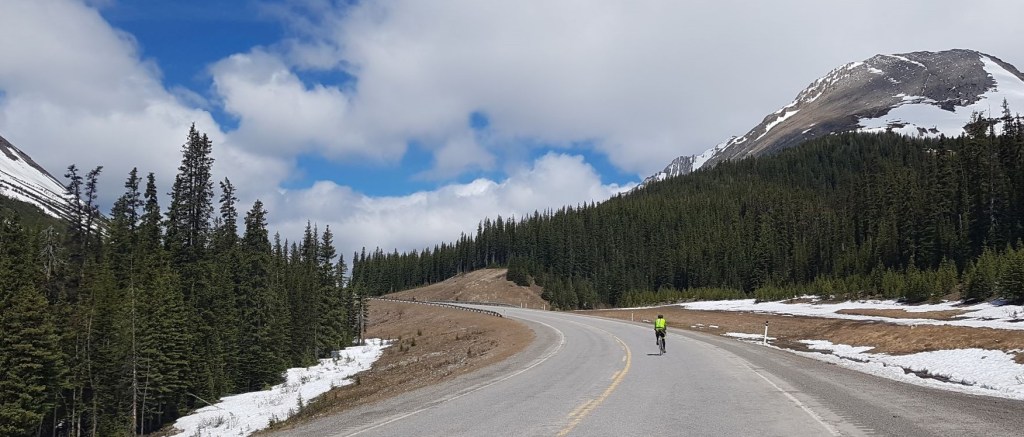
Mist Mountain absolutely dominates the skyline for most of the cycle. If you weren’t planning on scaling this monster, you will be after staring at it all day.
The Mist Creek Provincial Recreation Area is on the left, but I always stop at the trail head to Mount Lipsett on the right. At 24.5 km into the trip, it is an ideal spot to rest, have a bit to eat, and gird my loins for the final elevation push to the summit.
While the elevation gained to this point is approximately 381 m (1,275′) over 24.5 km, there is still another 331 m to gain, but only over 13.5 km.
From the Mount Lipsett trail head, there is a short downhill as you ride around the right side of Mount Lipsett. Personally, this is my favourite part of the ride as it is absolutely beautiful. Once around the corner, the elevation starts in earnest, and does not give it up until you are past the Arethusa pull-out on the right at approximately 36 km from the winter gates.

Once past Arethusa, the angle backs off to the Highwood Pass Day Use area, which is on the west side at approximately 37.3 km. I would recommend not stopping here yet, and instead continue all the way to the Highwood Pass, which is just another 500 m or so up the road.
At the Highwood Pass Summit, you can take your turn posing in front of the Highwood Pass Elevation sign. Please don’t hog the sign, and move your bike away so others can take their photos.

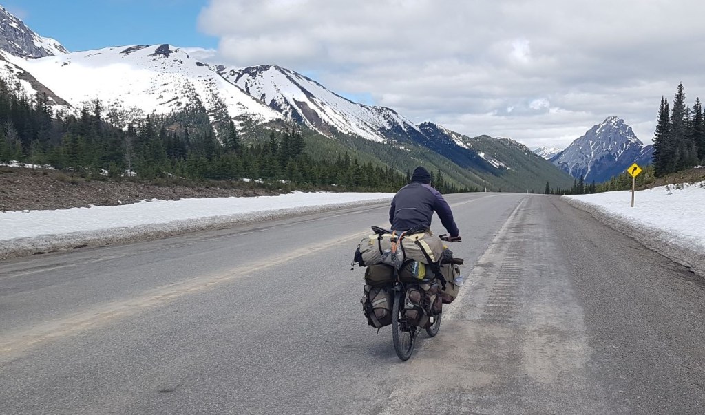
JUST when you are feeling good for riding up here, this old guy with 100 lbs of gear cycles by. Sigh…
Highwood Pass Cycle Return
On the way back down, I always stop at the Highwood Pass Day Use area for one more outhouse visit.
While the trip down is fast and fun, take a moment to enjoy the views going this way too.
If you found this post useful, please do me a huge favour and click the Star button to “Like” it. You can also follow my blog, follow me on Instagram, or join my FaceBook page Al’s Adventurers.
Alisen
Totals – Tracked on Strava
Date: Various trips
Group: Solo and club rides
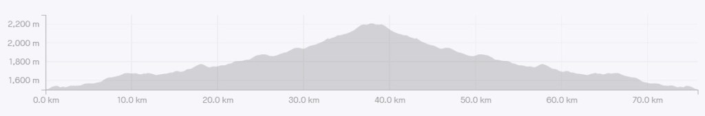
Distance: 75.5 km
Elevation: 1,093 m (3,606′)
Time: 4 hours (includes lunch & breaks)
South Gate to Highwood Pass
The Full G2G2G – South Gate to Pass, the North Gate, and back to South Gate
I love all things mountains! I live next door to the Canadian Rocky Mountains, however I travel the world to enjoy the many different mountain environments and cultures that I can. I hope you enjoy these trip reports, and that it inspires you to accomplish your own adventure goals.

Wow! In awe! Bravo! 😀
Awww shucks 🙂
Yeah, I’m going to second that about the cattle guards. I live in Texas and I’ve never heard them called Texas Gates, but I think I get why they’d be called that. To be honest, as I think every suspects, we have TONS of them. While not everybody is a cowboy, there’s still a lot of cattle, for sure!
I think we call them Texas Gates as an homage to the Lone Star State. Only Alberta does this. Other provinces call them cattle guards.
Not sure if you know this, but the very first cattle ranch was populated by Texan cows. They were herded up here on foot. The first time, they either started too late, or had bad luck, because 90% of the cows died along the way. They tried again the next year, started earlier, and 90% of the cattle survived, creating the Cochrane Ranch.
Well done! And thanks for providing such detailed information. We were canoeing on Lower Lake Kananaskis today and stopped at the gate to Highwood Pass to see what our window of opportunity would be to cycle the area. Hopefully we have the time and weather to fit in the ride to Mount Lipsett.
Oh wow! What a fantastic day to paddle on Kananaskis lake. That is absolutely fantastic. If you have any photos, please feel free to post on my FB. I’m sure others would love to see your adventure.
I biked from Canmore to Minnewanka to Tunnel mountain yesterday (started at 7:00 am to beat the heat). Minnewanka was like glass. So incredibly beautiful.
You can also bike from the north gate, but it’s even steeper.
The road was plowed two days ago. My cycle friends did it yesterday, which is why I finally got this post done. Not sure why it takes me forever to write these things up sometimes. Nothing like a deadline to get motived 🙂
Thanks for all the info you share, Alisen. It’s very helpful.
We did the Minnewanka loop you described last week, and also the 1A Vermillion Lakes to Johnson Canyon Loop. The lakes are especially beautiful first thing in the morning when the reflections are like mirrors. I also did the Baker Park (Calgary) to Chestermere loop ride on Monday. That was nice but the scenery isn’t a patch on the mountain scenery (although it is flatter!) Keep posting hikes as we’ll able to broaden our selection of options as the snow slowly disappears. Have you done Devil’s Gap near ghost Lake? It looks awesome … as long as our 4 x 4 can cope with the road.
The Ghost area is such a pain for access. Years (25+!!!) ago we had a real 4×4 and did some stuff in there, but I haven’t been since. We just got our VW Westfalia redone, and it’s lifted pretty high, so might try some more stuff in there. Let me know if you wan to go!
The Chestermere ride is nice for KM, but yeah, not much to look at. Good for you for getting KM on your bike!
Marvelous! And nice video too.
Thank you. The video is my hubby’s work 🙂
🙂
It’s kind of funny (and a little annoying) how some of these hidden gems become popular attractions. I can see why this is a popular cycling route though, especially since there are no vehicles allowed on the road until mid-June, there are great views, and a high possibility of wildlife sightings.
The cat is out of the bag on this one, that’s for sure. I’m part of the problem though, now aren’t I? 🙂
However, I did notice that the cycling routes were a bit quieter on Wednesday. It *feels* like people are getting back to work. Also, our Provincial government just added a $90 fee to visit our Provincial Parks, so perhaps people are trying to figure out other forms of entertainment.
I guess that’s what happens when an area becomes too popular. Is this $90 fee for day-use or for the entire year? Either way, I’m sure it’s a huge change for people to go from free to no longer free.
It’s $15 per day, and $90 for the year. Just like the National Parks now. I would be in favour of it IF I thought for one second that the Alberta UCP government wouldn’t use it as a cash grab. I have little faith they will use the money to improve and protect the park. This is the same government that tried to close and sell off Provincial Parks last year, so no, not a lot of trust there.
Ugh that’s terrible. It doesn’t seem right for the government to make some of these decisions that could have such long term repercussions without consulting with the general public (or environmentalists). Our annual parks pass is a bit more expensive than yours, but our government has now made it valid for two years. Our parks have become so crowded, which means there is more trash everywhere. It’s too bad that they aren’t adding much additional funding for our parks as they could certainly use it for maintenance and educational purposes.
Yes! Basic maintenance and education would be so nice. It also creates jobs. I guess I should run for office 🙂
Ha! You’d get my vote!
Would love to be there to see this.
I’m sure the restrictions will lift soon. If not, this cycle is available every year.
What a stunning ride! I think it would take me forever to complete this path though as I would be stopping every few metres to admire the view. Amazing!
Oh yes! And that is a good thing! I did a beautiful ride yesterday through these gorgeous mountain lakes. It felt like I stopped every few feet to take another photo. Biking is such a great way to see the world.
It is! Especially with a tail wind! 🙂
Great post Alisen and looks very nice Bike tour.
Also, I have to compliment you for the way you structured this post (and other posts on your blog). I also like you included the Bike Etiquette in your post, so we can learn something new (whoever is not into biking).
Thanks again for sharing such great content Alisen.
Hi! Thank you for the kind words, and for noticing the structure. In a past life, I was a Technical Writer, and I wrote software manuals and online help files. I can’t help but think that experience colours most of my writing now.
I can certainly recognise your technical background and I like when people write in such good order!
Great adventure
Thanks. Sometimes I think it’s more of a slog or a sufferfest than an adventure 🙂
Your blog is glorious.
Thank you – that’s very kind of you. Yours is something special too!!! Wowzers!
Your blog makes me tour virtually on my bicycle. Love the photo of a bird begging for some human food. Well done.
Oh! Good idea! Makes indoor training that much more enjoyable. Those birds don’t so much beg as rip the food out of your hand. They are cheeky little devils! 🙂
looks like FUNISHMENT TO ME!
Ha ha! It can be if you go all the way, if you have a heavy bike, or are really out of shape 🙂
Thanks for the post! I was wondering if you have tried this ride starting from the north end and how it compares? I understand it’s more elevation on shorter route (King Creek Ridge to Highwood Pass) wondering if this is doable on my hybrid?
Hi Jessica,
At the very end of this report, I include the north side ride. It shows the distance there and back (~35 km) and the elevation gain is ~490 m. So a short 15 km to gain 500 m. I’ve included the elevation profile.
Anything is doable if you’re game. I live down south and am a member of the Highwood Cycle Club who takes its name from the Highwood Pass, so that’s why I ride from here.
Enjoy, and let me know how it goes on your bike.
Alisen
We are group of six (2adults /2kids )/age 12and 9.,decent cyclist (most recently we biked the Camino from Porto.
We camping in kananaskis for few days,elkwood campground and bow valley.
We were planning to bike the highwood pass ,during this camping trip. Need some advice ?
Q1.if we managed to bike south to north gate …any option for kids and myself to get ride back with our bikes
Q2.is supported ride being planned by the club over next few weeks (17july+23july)
Hello, sorry for the late reply.
Q1 – Unless you arrange a ride in advance or drop a car, you are on your own to get back to the start.
Q2 – no supportive rides are planned with my club but I did see that a Gran Fondo was there last weekend, which would have been supported. There are a few Fondos that go to this area.
I was in the Highwood on Sunday and there is still snow at the Pass. Also, all of the day use areas are closed for various reasons (bears, repairs) so I’d make sure you had support before you head off.
Enjoy your trip!
Alisen